MJO812 Posted January 17 Share Posted January 17 Very Icy outside My car is caked with ice all over. I had to put more salt outside my house 1 Link to comment Share on other sites More sharing options...
Thunderblizzard Posted January 17 Share Posted January 17 About 1.7" of snow/sleet encrusted in ice here. Link to comment Share on other sites More sharing options...
40/70 Benchmark Posted January 17 Share Posted January 17 1 hour ago, Damage In Tolland said: Why not 4.5 or 5? Why not 2-3" of accretion? 1 Link to comment Share on other sites More sharing options...
40/70 Benchmark Posted January 17 Share Posted January 17 4 minutes ago, MJO812 said: Very musty outside My drawers are caked with skids all over. I had to put more porta potties outside my house Long detail? 1 Link to comment Share on other sites More sharing options...
40/70 Benchmark Posted January 17 Share Posted January 17 1 hour ago, Torch Tiger said: wasn't home, but looked like 6" or so here before the flip. Noted @wx2fishlives just NW of me with 3.8" and @Great Snow 1717also in Methuen measured 3.5" prior to sleet...is that unreasonable? I couldn't get to it until several hours after IP/frz rain. 1717 is not someone I would suspect of inflating amounts, as he is conservative and not a snow weenie. 1 hour ago, wx2fish said: 3.8" combined snow/sleet with some freezing drizzle on top. Link to comment Share on other sites More sharing options...
WxWatcher007 Posted January 17 Share Posted January 17 Long time since I’ve seen it this icy around here. Finally looks and feels like winter. 1 Link to comment Share on other sites More sharing options...
EMontpelierWhiteout Posted January 17 Share Posted January 17 7” on the nose here. Single measurement but this stuff is so light I assume no compaction. Event pretty much over here. Forecast this morning was for 3-6 so overperformer up in this part of NNE. 2 Link to comment Share on other sites More sharing options...
powderfreak Posted January 17 Share Posted January 17 3 minutes ago, EMontpelierWhiteout said: 7” on the nose here. Single measurement but this stuff is so light I assume no compaction. Event pretty much over here. Forecast this morning was for 3-6 so overperformer up in this part of NNE. Agreed, the ratios are high, but with cold temps it doesn’t matter. Its mid-January vibes as they should be. Link to comment Share on other sites More sharing options...
EMontpelierWhiteout Posted January 17 Share Posted January 17 1 minute ago, powderfreak said: Agreed, the ratios are high, but with cold temps it doesn’t matter. Its mid-January vibes as they should be. Yes love it. Deep winter feel. Link to comment Share on other sites More sharing options...
alex Posted January 17 Share Posted January 17 Can’t see the stake but it’s gotta be over a foot now. Radar looks clear but it’s still dumping. Beautiful evening 2 Link to comment Share on other sites More sharing options...
backedgeapproaching Posted January 17 Share Posted January 17 We were stuck in no man's land in SVT between the PF and crew band and the SE stuff most of the day. Pretty pedestrian rates and meh snow growth for big part of the day. Made up some ground with some 20-30:1 fluff this evening finished at 5.5" Link to comment Share on other sites More sharing options...
HIPPYVALLEY Posted January 17 Share Posted January 17 3 hours ago, radarman said: 4" final Same. We had a decent burst at the end. Link to comment Share on other sites More sharing options...
rimetree Posted January 17 Share Posted January 17 Finished with 3.5" before change to sleet and freezing rain. Super fluffy stuff this morning and figured we'd be good for at least 6 but the 2-4/3-5 calls were right. Link to comment Share on other sites More sharing options...
DavisStraight Posted January 17 Share Posted January 17 27 minutes ago, alex said: Can’t see the stake but it’s gotta be over a foot now. Radar looks clear but it’s still dumping. Beautiful evening Beautiful wood stove. Link to comment Share on other sites More sharing options...
alex Posted January 17 Share Posted January 17 Just now, DavisStraight said: Beautiful wood stove. Thanks. It’s a heating fireplace, a bit of a hybrid. It can actually be hooked up to duct work to integrate with the house heating system. Definitely recommend to anyone who wants to heat with something that looks like a fireplaces. Link to comment Share on other sites More sharing options...
klw Posted January 17 Share Posted January 17 7.8 inches, pure fluff 1 Link to comment Share on other sites More sharing options...
ma blizzard Posted January 17 Share Posted January 17 3.3" melted down to 0.51" 2.8" snow, 0.5" mostly sleet/zr Link to comment Share on other sites More sharing options...
tunafish Posted January 17 Share Posted January 17 2.8" final SWE 0.35" - Portland, ME 1 Link to comment Share on other sites More sharing options...
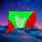
H2Otown_WX Posted January 17 Share Posted January 17 2 hours ago, The 4 Seasons said: Early snowfall map for CT, ill update tomorrow when i get the cocorahs data. Fx wasn't great but this was a super high impact 1-3" type event, about as bad as it could be for that little snowfall. Thanks to everyone who sent reports. If anything missing from here ill add it to the final one tomorrow. SNE map will be coming as well. You guys shoulda gone with your original call Link to comment Share on other sites More sharing options...
metagraphica Posted January 17 Share Posted January 17 2 hours ago, The 4 Seasons said: Early snowfall map for CT, ill update tomorrow when i get the cocorahs data. Fx wasn't great but this was a super high impact 1-3" type event, about as bad as it could be for that little snowfall. Thanks to everyone who sent reports. If anything missing from here ill add it to the final one tomorrow. SNE map will be coming as well. 3.1" here in Salem. 3" of snow. 0.1" ZR. Link to comment Share on other sites More sharing options...
Great Snow 1717 Posted January 17 Share Posted January 17 11 hours ago, Damage In Tolland said: Why not 4.5 or 5? Because I measured 3.5 right before the change to sleet. The sleet and freezing rain that followed the snow compacted the pack down to around 3 inches......I'm sure a weather savant such as you can understand why 3.5 inches rather than 3 inches is the most accurate measurement of the snow that fell... 1 Link to comment Share on other sites More sharing options...
jsw Posted January 17 Share Posted January 17 9 hours ago, HIPPYVALLEY said: Same. We had a decent burst at the end. Eyeballing about 3 inches here in downtown Brattleboro. 1 Link to comment Share on other sites More sharing options...
Great Snow 1717 Posted January 17 Share Posted January 17 10 hours ago, 40/70 Benchmark said: @wx2fishlives just NW of me with 3.8" and @Great Snow 1717also in Methuen measured 3.5" prior to sleet...is that unreasonable? I couldn't get to it until several hours after IP/frz rain. 1717 is not someone I would suspect of inflating amounts, as he is conservative and not a snow weenie. I love snow BUT there is no incentive for me inflate amounts. I may be mistaken but I think wx2fish said he lives close to Route 93 Exit 3 so it makes sense that he had slightly more than the 3.5 I measured. Link to comment Share on other sites More sharing options...
dryslot Posted January 17 Share Posted January 17 Finished with 5.5" here. 2 Link to comment Share on other sites More sharing options...
Great Snow 1717 Posted January 17 Share Posted January 17 2 minutes ago, jsw said: Eyeballing about 3 inches here in downtown Brattleboro. best be accurate or else the Tolland Society for Accurate Snow Measuring will be paying you a visit... Link to comment Share on other sites More sharing options...
dendrite Posted January 17 Share Posted January 17 3.9”/0.31” final Link to comment Share on other sites More sharing options...
mreaves Posted January 17 Share Posted January 17 Over performed in much of VT, at least from early expectations. VERMONT ...Addison County... Bristol 7.0 850 PM 1/16 Public Whiting 6.0 749 PM 1/16 Public ...Caledonia County... Groton 10.0 758 PM 1/16 Public 1 ENE Ryegate 8.0 745 PM 1/16 Public East Burke 7.0 824 PM 1/16 Public West Burke 7.0 951 PM 1/16 Public 2 SW Sutton 6.6 915 PM 1/16 Co-Op Observer North Kirby 3.5 500 PM 1/16 Public ...Chittenden County... Shelburne 8.0 939 PM 1/16 Public 2 SW Hinesburg 6.5 825 PM 1/16 Public St. George 5.9 854 PM 1/16 Public 1 NNW Burlington 5.6 945 PM 1/16 NWS Employee Underhill 5.5 743 PM 1/16 Public 1 S Essex Center 5.5 832 PM 1/16 NWS Employee 2 NW Westford 5.3 814 PM 1/16 NWS Employee Colchester 5.0 800 PM 1/16 Public 1 NE South Burlingto 5.0 1012 PM 1/16 NWS Office 2 NNW Williston 4.5 600 PM 1/16 NWS Employee 2 E St. George 4.5 410 PM 1/16 NWS Employee 2 SW Milton 4.5 1050 PM 1/16 NWS Employee Malletts Bay 4.0 330 PM 1/16 Public 1 N Colchester 3.5 400 PM 1/16 NWS Employee 1 ENE Essex Junction 3.4 359 PM 1/16 NWS Employee ...Essex County... East Concord 10.8 823 PM 1/16 Public 4 WNW Maidstone 6.0 1018 PM 1/16 Public ...Franklin County... Fletcher 7.0 905 PM 1/16 Public St. Albans 3.0 941 PM 1/16 Public ...Grand Isle County... Alburgh Center 4.0 803 PM 1/16 Public South Hero 3.0 852 PM 1/16 Public 2 NW Alburgh 1.5 943 PM 1/16 Public ...Lamoille County... Morrisville 7.5 727 PM 1/16 Public Johnson 6.0 939 PM 1/16 Public Elmore 5.5 744 PM 1/16 Public Jeffersonville 5.0 400 PM 1/16 Public ...Orange County... Orange 10.0 1002 PM 1/16 Public Vershire 9.0 848 PM 1/16 Public Randolph 9.0 909 PM 1/16 Public Tunbridge 8.9 812 PM 1/16 Public Fairlee 8.5 952 PM 1/16 Public Brookfield 8.0 940 PM 1/16 Public Newbury 7.0 731 PM 1/16 Public West Newbury 6.8 612 PM 1/16 Public Williamstown 5.5 853 PM 1/16 Public ...Orleans County... Orleans 6.0 917 PM 1/16 Public Westmore 6.0 752 PM 1/16 Public Albany 5.3 1003 PM 1/16 Trained Spotter Derby Center 5.0 906 PM 1/16 Public Barton 5.0 903 PM 1/16 Public Lowell 5.0 745 PM 1/16 Public 4 NNE Greensboro 4.2 400 PM 1/16 CoCoRaHS ...Rutland County... West Rutland 11.0 938 PM 1/16 Public Ira 10.0 808 PM 1/16 Public Shrewsbury 10.0 726 PM 1/16 Public Mendon 8.0 725 PM 1/16 Public Pittsford 8.0 906 PM 1/16 Public Pawlet 8.0 834 PM 1/16 Public 2 W Benson 7.5 750 PM 1/16 Public Hydeville 7.0 723 PM 1/16 Public Brandon 7.0 724 PM 1/16 Public Hubbardton 6.5 759 PM 1/16 Public 3 SSW Wallingford 5.0 727 PM 1/16 CoCoRaHS ...Washington County... Fayston 8.5 947 PM 1/16 Public 1 SW East Barre 8.0 813 PM 1/16 NWS Employee North Fayston 8.0 953 PM 1/16 Public Montpelier 6.5 725 PM 1/16 Public ...Windsor County... Norwich 8.2 802 PM 1/16 Public Bethel 8.0 1013 PM 1/16 Public South Royalton 8.0 859 PM 1/16 Public 1 NE Pomfret 7.5 937 PM 1/16 Public Weathersfield 5.5 853 PM 1/16 Public ...Bennington County... Landgrove 8.2 939 PM 1/16 WeatherNet6 1 WNW Mountain View 6.2 900 PM 1/16 Trained Spotter Sunderland 6.2 900 PM 1/16 Social Media West Arlington 6.0 402 AM 1/17 WeatherNet6 Readsboro 4.1 745 PM 1/16 Social Media 5 NNE Stamford 2.5 400 PM 1/16 CoCoRaHS ...Windham County... Brattleboro 4.0 730 PM 1/16 Social Media Athens 3.8 715 PM 1/16 Social Media Link to comment Share on other sites More sharing options...
40/70 Benchmark Posted January 17 Share Posted January 17 29 minutes ago, Great Snow 1717 said: I love snow BUT there is no incentive for me inflate amounts. I may be mistaken but I think wx2fish said he lives close to Route 93 Exit 3 so it makes sense that he had slightly more than the 3.5 I measured. Agreed. I used your measurement. Link to comment Share on other sites More sharing options...
Great Snow 1717 Posted January 17 Share Posted January 17 4 minutes ago, 40/70 Benchmark said: Agreed. I used your measurement. ..just make sure you have the royalty check out to me by Friday...Thank you! 1 1 Link to comment Share on other sites More sharing options...
powderfreak Posted January 17 Share Posted January 17 22 minutes ago, mreaves said: Over performed in much of VT, at least from early expectations. Mid-level magic. Link to comment Share on other sites More sharing options...

Recommended Posts
Create an account or sign in to comment
You need to be a member in order to leave a comment
Create an account
Sign up for a new account in our community. It's easy!
Register a new accountSign in
Already have an account? Sign in here.
Sign In Now