The 4 Seasons
-
Posts
6,379 -
Joined
-
Last visited
2 Followers


About The 4 Seasons

- Birthday 07/30/1985
Recent Profile Visitors
9,985 profile views


-
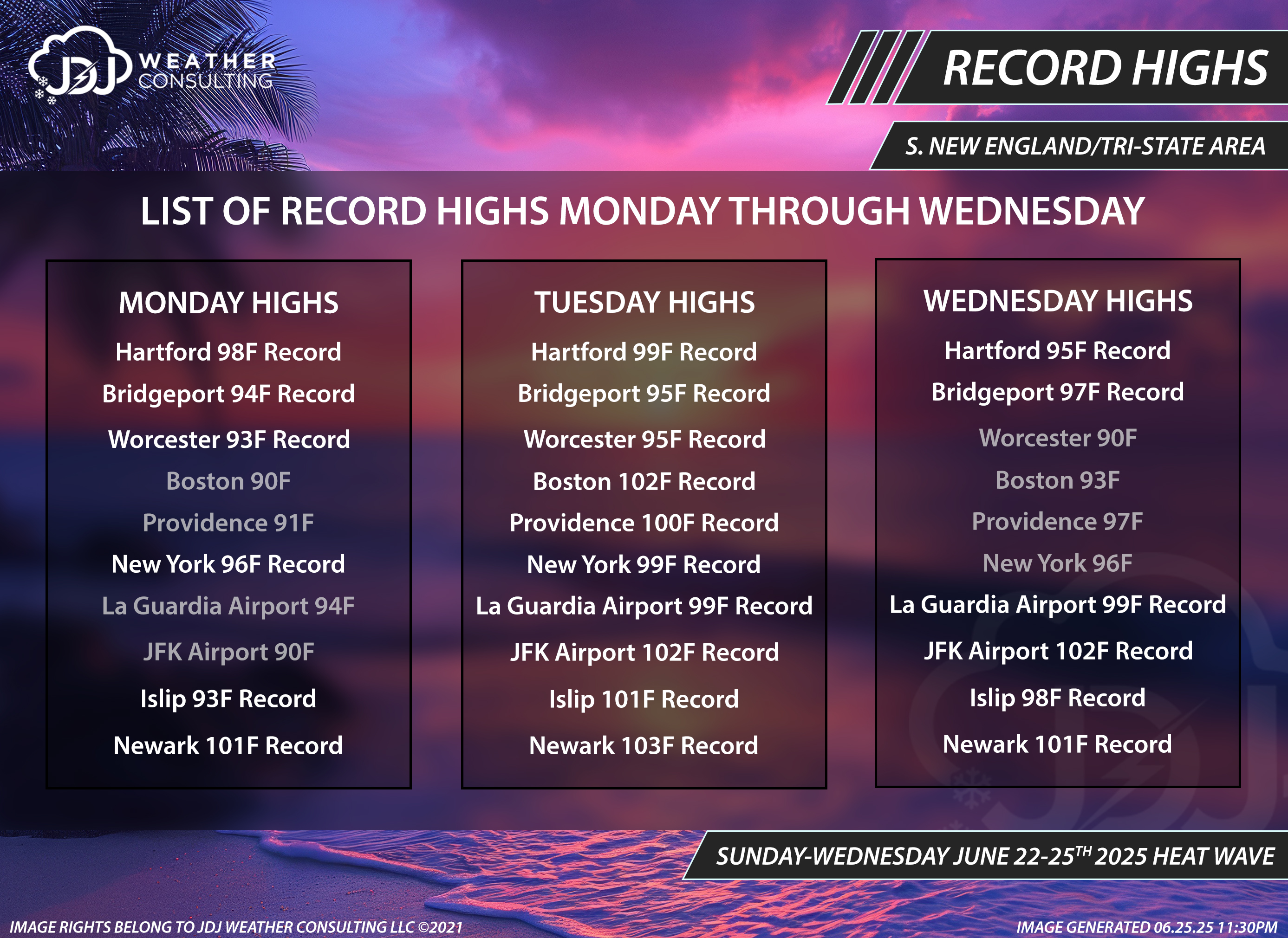
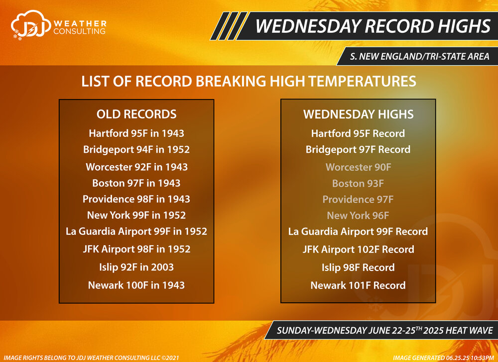
Record highs mon-wed and wed records

-
Mon, Tue, Wed record highs and Wed highs compared to old records for all 10 climo sites in BOX/OKX. I doubled checked everything this time so hopefully no errors
-
you're right, i made this right after the pm climo (CLI) came out and it was 85, the next update was at 1am and they changed it to 90, i didnt notice. Looks like they hit 90 really late (7-8pm) after the winds switched from E to S. ill update it, thx for the info. Still no record tho
-
typo, thanks fixed
-
Records yesterday and today for all SNE/Tri-State climo sites. *Fixed ORH typo **Updated BOS Monday high
-
For sure. Mar 4-6 2001 was one hell of a storm despite under performing a bit in CT. Still a solid 10-18 for most of the state. I was pretty much right on with my memory of that storm, snow began late Sunday AM and the last flakes ended just after midnight Wednesday morning. About 62 hours.
-
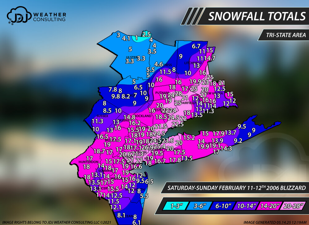
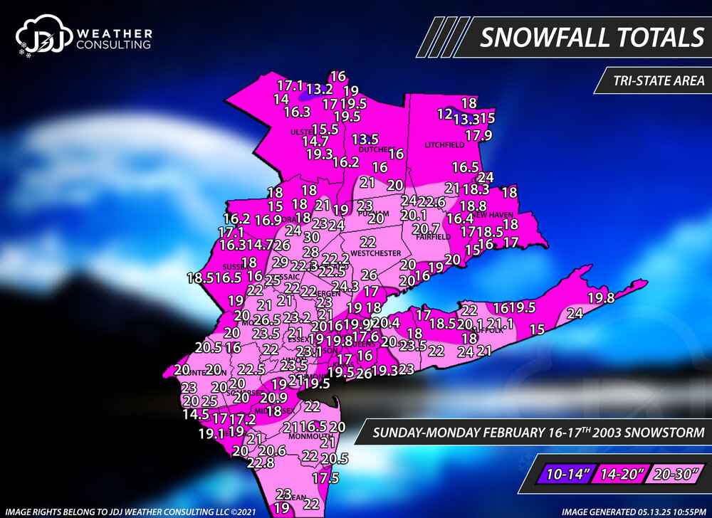
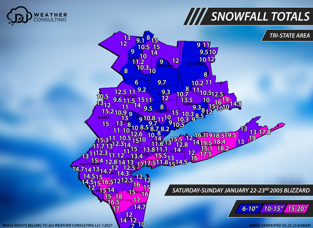
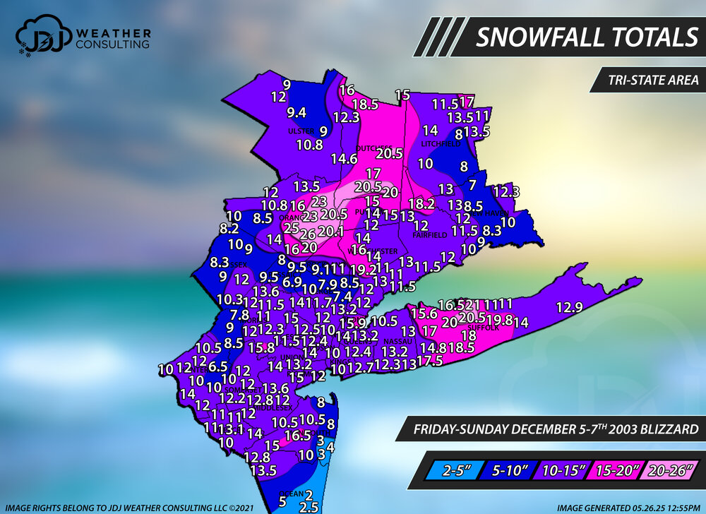
Hey @H2Otown_WX i just added a full radar loop of your favorite storm Dec 30th 2000 and Feb 5th, Mar 4-6th 2001 as well as Dec 2003 and Jan 2005. Even the blizzard of 96 is now up. All new snowfall maps as well. I cant link them here cuz the file sizes are massive.
-

Winter 2024-2025 All Tri-State Snowfall Totals Maps
The 4 Seasons replied to The 4 Seasons's topic in New York City Metro
The main archive that has all the storms is updated back to 2018-2019 so far and will stop at 2000 (probably take me till sometime in 2026) The historic archive has all 12"+ big/historic storms and 1996 and PD2 is there and about 20 others, which is also being worked on The big thing recently was adding radar and tri-state maps to all the storms -
Winter 2024-2025 All Tri-State Snowfall Totals Maps
The 4 Seasons replied to The 4 Seasons's topic in New York City Metro
Hey everyone i just updated our Historic Storms page on our site to include Tri-State Area snowfall maps for every event as well as a full radar loop for all storms post 1995. There's a lot of new storms in there including Boxing Day, PDII, Feb 2006 Blizzard, Dec 2003, Jan 2005 and of course Mar 4-6 2001, Dec 2000 and more. I'll be continuing to update it with more new storms throughout the year. https://www.jdjweatherconsulting.com/historic-storms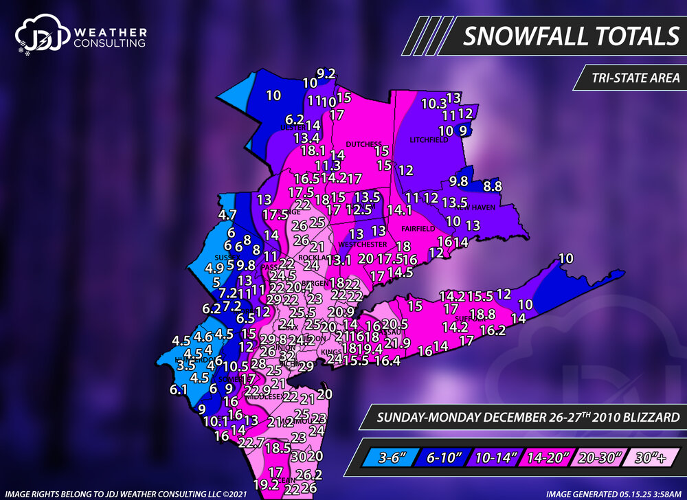
-
Winter 2024-2025 All Tri-State Snowfall Totals Maps
The 4 Seasons replied to The 4 Seasons's topic in New York City Metro
There is now. I found two archives for radar. There is now a new section of the site that has radar loops for the entire event as well sfc and h5 maps for past moderate events (3"+) or higher. It's being updated on a weekly basis but i am back 5 years now to 2020. https://www.jdjweatherconsulting.com/storm-archive -
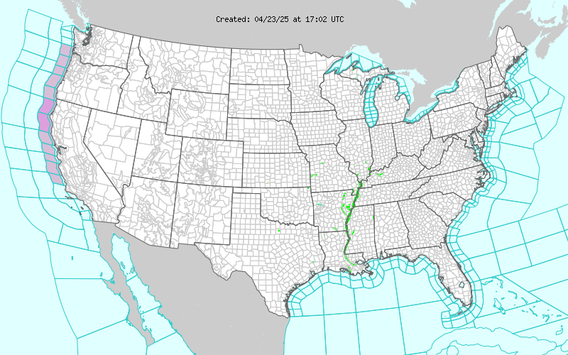
I don't know if i've ever seen this map this empty before, for a second i thought it didn't load. It's quiet out there, a little too quiet
-
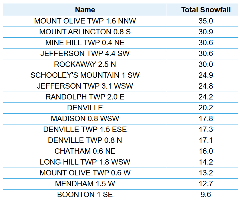
Nice. I saw that on the COOP but i think i just included the 4.4SW Jefferson 30.6". Some of these are so close together i can't fit them all but that 30.9 matches up pretty close to the 30.6, which was also in Mine Hill
-
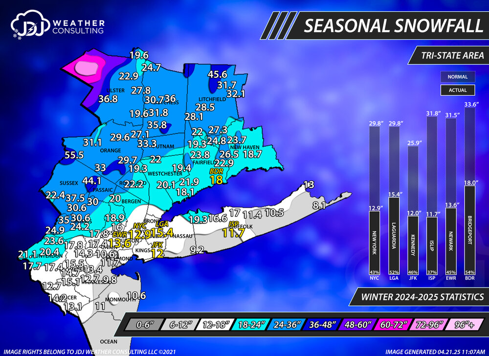
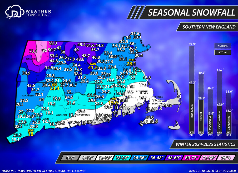
Final seasonal snowfall totals for the 24-25 season. I added some stats on the side for the climo sites and compared them to normal. There's a snowfall progression animated GIF throughout the season as well as Tri-State/CT maps on our website under the 24-25 seasonal snowfall page.
-
Winter 2024-2025 All Snowfall Totals Maps (CT/SNE)
The 4 Seasons replied to The 4 Seasons's topic in New England
Update for the 24-25 season totals FINAL. -
Just finished the final seasonal snowfall map for the 24-25 season. I added stats to the side for the climo sites as well as a progression throughout the season which you can see on our site. Everything is updated in the 24-25 snowfall maps page.