powderfreak
-
Posts
77,232 -
Joined
-
Last visited
2 Followers

About powderfreak

-

July 2025 Obs/Disco ... possible historic month for heat
powderfreak replied to Typhoon Tip's topic in New England
Maybe we are all just used to it because we’ve seen it for decades. No one on here will say BOS is indicative of the entire New England area… we usually note it in winter. None of this seems earth shattering that BOS is a different climate, it’s been like that for decades. Just like if we were in a pattern with cooler air aloft and in the north, no one is using MWN as a judge of the SNE climate either. -
July 2025 Obs/Disco ... possible historic month for heat
powderfreak replied to Typhoon Tip's topic in New England
Do you want them to be hotter? You sound so disappointed. The ones running lower anomalies are on the ocean or closer to maritime air. That has less variance. They don’t radiate anyway. Its ok if it’s not an absolute furnace everywhere. -
July 2025 Obs/Disco ... possible historic month for heat
powderfreak replied to Typhoon Tip's topic in New England
Low of 70F… +15. BTV hasn’t been below 77F tonight. That’s a tough night if you don’t have A/C. Nocturnal storms and clouds, and away from the cooler maritime air mass up this way.
-
July 2025 Obs/Disco ... possible historic month for heat
powderfreak replied to Typhoon Tip's topic in New England
You can toss overnight lows all you want, but it’s why everyone in the SNE hills, NNE, mtns, ME coast is installing A/C these days compared to 10-15 years ago. I get why folks often want to toss those temps once you’ve given into artificial cooling and are tucked soundly in bed next to the hum of a cooling source… but there’s been a “real feel” effect and you see it with every mini split or AC install that wasn’t there a decade ago. People used to get through summer with windows open at night. The warm mins have had a real societal impact. -
July 2025 Obs/Disco ... possible historic month for heat
powderfreak replied to Typhoon Tip's topic in New England
Remember when we used to spend weeks arguing with DIT about 57-58F at the ASOS’ and 61-62F on his Davis… whether it was humid or not because it hovered around the magical 60 line on these graphics? Its like we’ve +10 the dews in a decade. -
July 2025 Obs/Disco ... possible historic month for heat
powderfreak replied to Typhoon Tip's topic in New England
Humid evening. 81/70
-
July 2025 Obs/Disco ... possible historic month for heat
powderfreak replied to Typhoon Tip's topic in New England
Tough crowd here lol. -
July 2025 Obs/Disco ... possible historic month for heat
powderfreak replied to Typhoon Tip's topic in New England
Creemee to milkshakes in seconds. Just feels like the new normal more and more every summer. -
July 2025 Obs/Disco ... possible historic month for heat
powderfreak replied to Typhoon Tip's topic in New England
84/72. Man I love when the dews are 22 degrees warmer than the average low, ha. -
July 2025 Obs/Disco ... possible historic month for heat
powderfreak replied to Typhoon Tip's topic in New England
There’s no way that’s accurate in VT and upstate NY is there? I’m at like 7” since June 1. -
July 2025 Obs/Disco ... possible historic month for heat
powderfreak replied to Typhoon Tip's topic in New England
Ha, I mean BOS and BDL are +3.2. Its been a warm start to the month. -
July 2025 Obs/Disco ... possible historic month for heat
powderfreak replied to Typhoon Tip's topic in New England
High of 88F here, HI got to 91F. Average high of 79F. +4 start to the month. -
July 2025 Obs/Disco ... possible historic month for heat
powderfreak replied to Typhoon Tip's topic in New England
86/63 -
It was that Powder Magazine article in 1995 and he was featured in others in the late ‘90s that tuned me into him as a kid. They always used to reference him in the skier’s periodical of record. Good find!
-
July 2025 Obs/Disco ... possible historic month for heat
powderfreak replied to Typhoon Tip's topic in New England
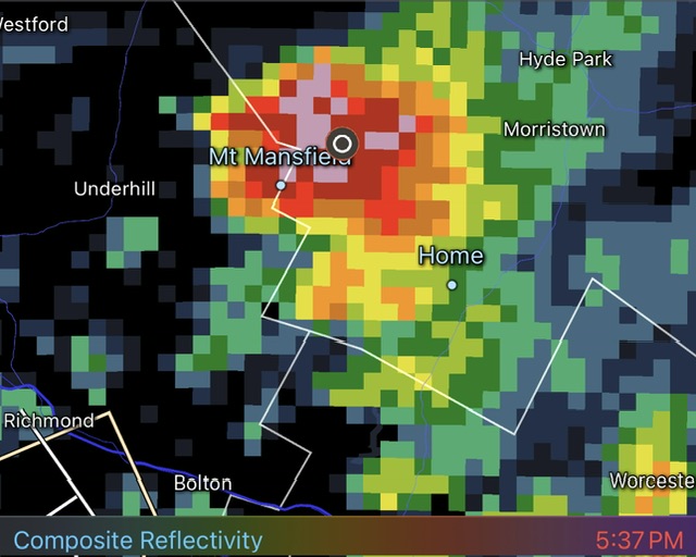
Got absolutely f*cked a little while ago on Spruce Peak above 3,000ft in the core of this. Dime sized hail and the heaviest rain imaginable… had to be 3”/hr stuff. Route turned into a muddy torrent. Still was able to submit the hail report to BTV during it, hiding out in the entryway to the patrol building . That shit hits differently at that elevation. Thunder and lightning gives you pause.