All Activity
- Past hour
-
I don’t think it’s hit 100 in Greensboro or Winston-Salem since 2012.
-
Sounds nice! I gave up a few weeks ago and will try again in September. I want a natural looking lawn with lots of clover, a few wildflowers, etc, 0.20 final total for the event
-

Central PA Summer 2026 Discussion/Obs Thread
pawatch replied to Voyager's topic in Upstate New York/Pennsylvania
62 degrees and partly foggy. -
Predicted high of 104 here on Friday. But 103 in Philly. Interesting. I'll take the under here. 99. Never seen 100 here, but maybe this will be the one.
- Today
-

Central PA Summer 2026 Discussion/Obs Thread
mahantango#1 replied to Voyager's topic in Upstate New York/Pennsylvania
URGENT - WEATHER MESSAGE National Weather Service State College PA 222 AM EDT Mon Jun 29 2026 PAZ019-026>028-035-036-045-046-049>053-056>059-063>066-300000- /O.NEW.KCTP.XH.A.0001.260701T1600Z-260704T0000Z/ Southern Centre-Huntingdon-Mifflin-Juniata-Fulton-Franklin- Southern Clinton-Southern Lycoming-Union-Snyder-Montour- Northumberland-Columbia-Perry-Dauphin-Schuylkill-Lebanon- Cumberland-Adams-York-Lancaster- Including the cities of Selinsgrove, Lewisburg, Berwick, Lewistown, Carlisle, Lock Haven, Mount Union, Lancaster, McConnellsburg, Harrisburg, Williamsport, Lebanon, Sunbury, Huntingdon, Hershey, Mifflintown, Shamokin, Chambersburg, Gettysburg, Newport, State College, Bloomsburg, Pottsville, Danville, and York 222 AM EDT Mon Jun 29 2026 ...EXTREME HEAT WATCH IN EFFECT FROM WEDNESDAY AFTERNOON THROUGH FRIDAY EVENING... * WHAT...Dangerously hot conditions with heat index values between 105 and 110. * WHERE...A portion of central Pennsylvania. * WHEN...From Wednesday afternoon through Friday evening. * IMPACTS...Heat related illnesses increase significantly during extreme heat and high humidity events. * ADDITIONAL DETAILS...Very warm low temperatures, mainly in the low to mid 70s at night will not offer much relief from the heat. This combined with multiple days of near record breaking temperatures will amplify the impacts from the heat and humidity. PRECAUTIONARY/PREPAREDNESS ACTIONS... Drink plenty of fluids, stay out of the sun, and stay in an air-conditioned room. Remember your pets and provide them with plenty of water and shade if left outdoors. -
Best of luck in your new home! You've been here forever, will be weird not having your obs during the winter.
-
Will you turn guest viewing back on at some point?
-

2026-2027 Super El Nino
Stormchaserchuck1 replied to Stormchaserchuck1's topic in Weather Forecasting and Discussion
Summer cold in the Arctic since the 2012 arctic ice melt low has really been phenomenal! Anyone want to offer a theory on why that is? -

2026-2027 Super El Nino
GaWx replied to Stormchaserchuck1's topic in Weather Forecasting and Discussion
The Arctic mean temp. N of 80N, helped by a +AO, still didn’t reach freezing as it actually cooled very slightly yesterday! The prior latest on record (back to 1958) to first exceed 0C was June 20th (2013). Will it finally exceed 0C before the end of the month? Time’s running out and the model consensus has BN temps persisting. It had come within 0.35C on June 27th and then yesterday fell a little to 0.47C away: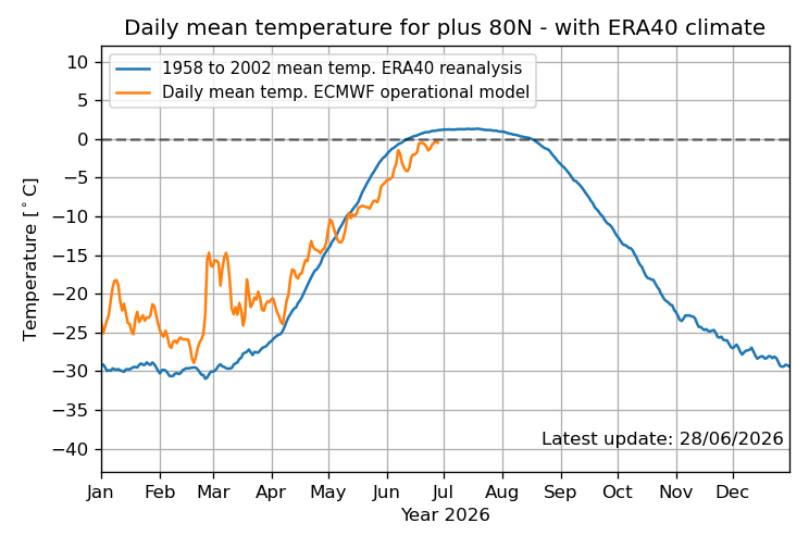
-
The UKMET keeps developing this into a weak TD and then dissipating it well offshore the SE US as it moves SW, WSW, W, and then WNW. I doubt this ever becomes a TD when considering other models: MET OFFICE TROPICAL CYCLONE GUIDANCE FOR NORTH-EAST PACIFIC AND ATLANTIC GLOBAL MODEL DATA TIME 0000UTC 29.06.2026 NEW TROPICAL CYCLONE FORECAST TO DEVELOP AFTER 30 HOURS FORECAST POSITION AT T+ 30 : 32.5N 72.5W LEAD CENTRAL MAXIMUM WIND VERIFYING TIME TIME POSITION PRESSURE (MB) SPEED (KNOTS) -------------- ---- -------- ------------- ------------- 1200UTC 30.06.2026 36 31.5N 71.9W 1012 26 0000UTC 01.07.2026 48 31.1N 72.1W 1011 26 1200UTC 01.07.2026 60 30.8N 73.0W 1012 23 0000UTC 02.07.2026 72 30.8N 74.3W 1013 21 1200UTC 02.07.2026 84 31.1N 75.8W 1015 18 0000UTC 03.07.2026 96 31.8N 77.2W 1016 18 1200UTC 03.07.2026 108 CEASED TRACKING
-
LOT has seven consecutive days in the 90s starting tomorrow. We’ll see if that pans out, but am concerned about convective activity getting in the way later in the week.
-
I will gladly step outside during a thunderstorm in this weather.
-

Pittsburgh PA Summer 2026 Thread
TimB replied to TheClimateChanger's topic in Upstate New York/Pennsylvania
As it stands now, the NWS point and click has temps not dropping below 75 at KPIT Wednesday/Thursday/Friday. That last happened on three consecutive days in 1917, and never at the airport observing site. I don’t think the highs reach the more absurd levels that some models and forecasts show, and history just doesn’t favor days and days of mid to upper 90s, but consecutive days of very warm lows seems very plausible. Something to watch. -
Your area and others nearby have largely missed out on the most intense summer heat in recent years. Much of that comes down to the large-scale pattern, which has often been influenced by forcing that hasn't favored persistent heat domes or strong upper-level ridges expanding into the central US/Midwest. Meanwhile, both coasts have experienced some of the most significant heat events in history this decade (such as the Pacific Northwest in 2021, the western March heatwave this year, and the upcoming historic heatwave for the East). Even last summer the EC experienced record breaking heat for a time, while we missed out on it. That’s not to say that we haven’t had our fair share of warmth (for many Midwestern cities, 2024 was the warmest year on record after all), but we’ve been lacking these prolonged, extreme, anomalous heat events relatively speaking, especially during summer, and instead have quietly accumulated positive temp departures through sustained, slightly to moderately above normal conditions. For instance, last June is the 6th warmest on record for Chicago, yet the temp only maxed out at 95 that month (and for all of summer). Those background patterns won't stay the same forever though, and at some point they'll likely shift in a way that's more favorable for extreme heat reaching your area again, including the return of triple-digit temperatures. Then you also have to take into account CC which has severe implications, but won’t go down that rabbit hole.
-
I just got it two hours ago and it is very hot. WX/PT
-
it would be nice to have a winter where NYC had 0.0" snow. perhaps this is the one?
-

2026-2027 Super El Nino
jaxjagman replied to Stormchaserchuck1's topic in Weather Forecasting and Discussion
Seems like right now 82-83 would be a focal point and not 97-98,when looking at analogs.97-98 had one of the 3 stronest DMI'S on record the last half centurry.JMA isnt showing this with it and its esembles right now,just one.But who know,DMI peaks into fall,maybe that one will be right..lol -

-
Congrats, post pics
-

E PA/NJ/DE Summer 2026 Obs/Discussion
The Iceman replied to PhiEaglesfan712's topic in Philadelphia Region
That cell hit a force field as it approached lower bucks. Picked up only .10” -
Don’t see any thunderstorms or good rain to break the heat
-

2026 Mid-Atlantic Severe Storm General Discussion
SnowenOutThere replied to Kmlwx's topic in Mid Atlantic
I’m traveling up to north central PA Saturday for a family Fourth of July. Think they might see storms? -
 DCA: 98, 99, 99, 98 BWI: 98, 99, 100, 98 IAD: 98, 99, 99, 98 SBY: 96, 96, 97, 97 RIC. 98, 99, 101, 98 QPF: 0.8”
 -
For those that want to cool off.... Advisories One product issued by NWS for: 5 Miles N Deer Lodge MT Winter Storm Warning URGENT - WINTER WEATHER MESSAGE National Weather Service Missoula MT 616 PM MDT Sat Jun 27 2026 MTZ007-280830- /O.CON.KMSO.WS.W.0004.000000T0000Z-260629T1500Z/ Butte/Blackfoot Region- 616 PM MDT Sat Jun 27 2026 ...WINTER STORM WARNING REMAINS IN EFFECT UNTIL 9 AM MDT MONDAY ABOVE 6500 FEET... * WHAT...Heavy wet snow expected above 6500 feet. Total snow accumulations of 4 to 8 inches, with 8 to 16 inches across the Anaconda Pintler Mountains. Snow levels may briefly lower and could produce minor slushy accumulation at Homestake and Macdonald Pass. * WHERE...Georgetown Lake, backcountry and higher elevation areas. * WHEN...Until 9 AM MDT Monday. * IMPACTS...Plan for winter-like conditions in the backcountry and higher elevations. Cold temperatures, wind, and wet snow will elevate the risk of hypothermia. Heavy wet snow may down trees, blocking access to backcountry roadways.
-

Fireworks Heat Contest W 7/1 - S 7/4 for Five MA Airports
JenkinsJinkies replied to nw baltimore wx's topic in Mid Atlantic
DCA: 99, 100, 103, 101 BWI: 99, 100, 102, 102 IAD: 98, 100, 101, 101 SBY: 98, 100, 100, 100 RIC: 100, 100, 104, 101 Total Rain: 0.2


.thumb.gif.f92b16c631a1d15d405ed77b33f0710d.gif)