

Kmlwx
-
Posts
13,215 -
Joined
-
Last visited
About Kmlwx

- Birthday 09/14/1991
Recent Profile Visitors
13,725 profile views


-
That storm coming down the Potomac looks healthy and supercellular.
- 1,305 replies
-
- 1
-

-
- severe
- thunderstorms
- (and 2 more)
-
Same general setup here. On a hill and away from the trail by a good bit. Can definitely hear the roar of the stream/creek when it gets high though. My friends and I found a fish well up into the branches of a tree after the June 2006 flooding. I don't think I've seen water levels that high since then.
-
My PWS is reporting an 80 degree dewpoint....has happened several times this summer already...awful.
-
NW Branch up near Kemp Mill - I use this site to monitor - https://waterdata.usgs.gov/monitoring-location/USGS-01650500/#period=P7D&showMedian=true&dataTypeId=continuous-00065-0
- 1,305 replies
-
- 1
-
-
- severe
- thunderstorms
- (and 2 more)
-
Yeah - he's mostly fine when he sticks to just the facts...also when he isn't blocking a lane of travel on a road
-
Good lord they look like they are on steroids! What a harvest!
-
12z HRRR blows up robust convection for the DC/Baltimore corridor especially in the 0-2z timeframe. PWATS near 2 inches in parts of the area...would think flooding risk with this activity - even if not super slow moving. Creek near the house rose to around 8ft during the other night's heavy rainfall. Highest in the past few years.
- 1,305 replies
-
- 1
-
-
- severe
- thunderstorms
- (and 2 more)
-
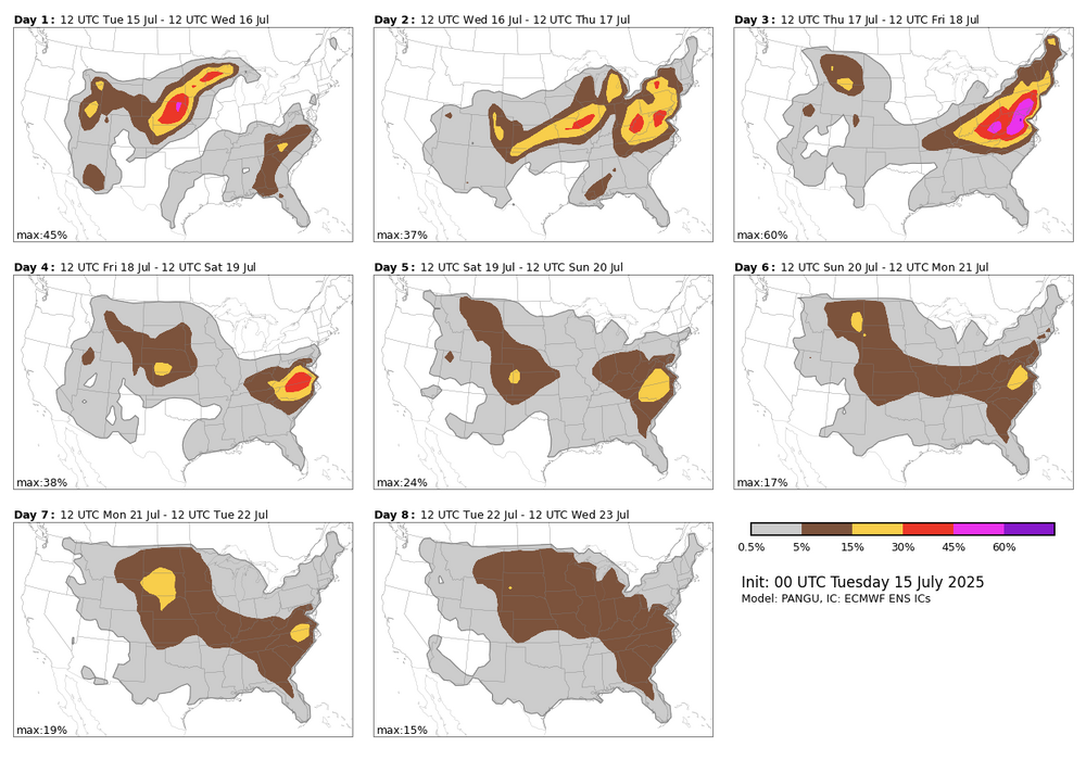
This is only one of the available algorithms. Note that they tend to be VERY robust so take with a grain of salt. I really only use it as a Day 4-8 "first guess" area to look for.
- 1,305 replies
-
- 1
-
-
- severe
- thunderstorms
- (and 2 more)
-
The NCAR AI severe page indicates a hefty chance of severe on Thursday - but SPC has held off on any risk areas due to the uncertainty from MCVs and prior day convection (and the position of the front). Bears watching.
- 1,305 replies
-
- 1
-
-
- severe
- thunderstorms
- (and 2 more)
-
Mother Nature is probably getting the ground nice and soggy and flood-prone in time for the Chesapeake-Potomac Hurricane of 2025.
-
Slow storm motions so far. Also sort of weak looking - definitely (at least so far) more of a heavy rain/flooding threat than a severe.
- 1,305 replies
-
- 2
-
-
- severe
- thunderstorms
- (and 2 more)
-
Related (but not directly to today) - has anyone using GR2AE or GR2 noticed lower resolutions? I've tried various color tables and while I might just be imagining things, it seems like the data is just blockier/lower resolution. I looked at the GR Owners forum and didn't on a cursory glance see anything. I am on the latest release (at least latest as of what I saw when I looked a week or so ago). Again - might be my imagination but it just "feels" way lower resolution than I am used to - even like as low as Level 3 data. This is coming through via my AllisonHouse subscription too...so presumably the data feed is not the issue.
-
The longer range 12z HRRR looked really solid....
- 1,305 replies
-
- 1
-
-
- severe
- thunderstorms
- (and 2 more)
-
Funny how sometimes we don't get a watch until there's a consolidating/existing line of storms well into the area. Other times there's hardly anything on radar except at the outskirts and we get a watch.
-
I guess this is good if it's accurate - maybe not so good if it's not so hot. I didn't see the HRRR referenced in that PDF - is that continuing?


