Search the Community
Showing results for tags 'severe'.
Found 24 results
-
I'm doing it....the 2026 iteration starts today. With potential warm weather on the horizon, we will likely see the start of the pencil thing gusty shower line season. @yoda - I feel like you're usually on board with early tracking with me. Excited to get back to our smaller spring/summer crew...The winter weenies can take their bickering away soon enough. As much as I hate summer heat - I tolerate it for thunderstorms. And now....I will go back to watching CFS/weeklies/CSU-MLP/CIPS pages for signs of our first threats!
- 801 replies
-
- 8
-

-
- severe
- thunderstorms
- (and 7 more)
-
Sure looks like a severe signal showing up between 200-240 hours.
- 276 replies
-
- 3
-
-
- severe
- mountain snow
- (and 1 more)
-
 Continuing discussion and eventually observations/nowcast posts for the Monday severe weather event potential can go here. @WxUSAF or other mods please pin this thread if you get the chance. 15% TOR and 60% WIND are extremely rare in these parts. While I am not downplaying anything - I do think the appearance of 60% wind has a lot to do with the new SPC outlook methodology. Nonetheless, an active weather day tomorrow seems on tap. Usual failure modes still exist (stabilizing cloud cover or early day showers) The shear environment is pretty insane.
- 1,093 replies
-
- 6
-

-
-
- severe
- thunderstorms
- (and 1 more)
-
The 2025 iteration needs an early start due to a marginal threat for severe tomorrow (2/16)! Have at it!
- 1,378 replies
-
- 8
-
-
-
- severe
- thunderstorms
- (and 2 more)
-
The GFS joined the Euro with some potential snowy hi-jinks to welcome met spring. As was noted, virtually all decent March/April snows over the last 50 years featured a cooperative or at least non-hostile pacific and MJO in Phase 2/3. It looks like we may be hanging out in 2 around the time the snowfall is showing up on the models.
-
Will we see our first heatwave? Severe weather? Or just a continuation of average to below average precip, above average temps and windy conditions?
-
Level 3 threat for eastern half of NC and SC tomorrow.
-
It's early, but might as well do the annual severe thread (people were talking about it in the long range thread!). I don't have the @WxWatcher007 scale handy on this computer - but I usually post it for posterity for the upcoming severe season. Anything from discussing past events to potential upcoming patterns/analogs, and discussion about more specific upcoming threats can be posted in here. A while ago we stopped doing event-specific severe threads for most things. Whether we do that or not - this is the general thread. Have at it!
- 1,696 replies
-
- 3
-
-
- severe
- thunderstorms
- (and 5 more)
-
Well, we are just twelve weeks out from December, so I thought I would start a spec thread... I actually like these ideas in the article below: https://www.severe-weather.eu/long-range-2/winter-2024-2025-first-snowfall-predictions-united-states-canada-europe-fa/ I tend to think that our best shots at winter will be late November to late December, and then it gets warm and maybe stays warm. That said, as others have noted in the main discussion thread for fall, the strength of this La Nina is important. The IO is important. The PDO is important. The MJO is very important. PDO -> The September Cansips has the PDO staying solidly negative for the winter, and not really even coming up for air at that. MJO -> This will tend to favor warm phases as phase 8 will be cooler than normal and that limits convection there. IO -> Off the coast of Eastern Africa, there is warm water depicted. That would favor phases 1-2 of the MJO. It also favors warmer than normal water over the Maritime Continent which favors 4-6. 500 Heights over NA -> November a ridge is shown to be out West. It transitions eastward as December progresses, and then parks itself over eastern NA for Jan and Feb - monster SER of sorts. Maybe by April it relents. The NAO might be negative for the first 1/3 of winter before returning to a net positive state. It would not surprise me to see the pattern relax by April, and we see chances for snow in early April (especially the mountains). SSTs -> The La Nina on Cansips appears to fade significantly by February. By next summer, we might be seeing Nino conditions for the western 3/4 of the Pacific. We have talked about gradient. @Typhoon Tiphas mentioned gradient many times(I think I have the correct poster). That means the delta (difference) between the La Nina and the waters around it matters. The steeper that gradient, the more of a stimulus we get. El Nino was kind of a washed out gradient last winter, and we got washed out results on the EC. From the recent climate.gov ENSO blog, "Said more simply, it’s not just how much warmer or colder than average that part of the tropical Pacific is that jumbles up the tropical atmosphere, it’s the difference in warming or cooling compared the rest of the Pacific. And that’s where the relative ONI comes in! So where do things stand? The regular ONI for May-July was +0.2°C. But the relative ONI was already down to -0.4°C. That means there could be a scenario later this year where the ONI is not yet below -0.5°C, but the relative ONI already is, and the atmosphere might start reflecting La Niña-like impacts. Doesn’t that seem like a pain to communicate? " To me, since the Pacific basin is warmer than normal, La Nina might well have a threshold warmer than what we saw maybe 30 years ago. That means that what we see as a weak La Nina might actually be a bit stronger than we think. So, the weak La Nina forecast below might well be a bit stronger given that La Ninas might have increasingly warmer SSTs. Overall Forecast: I do think we see some crazy cold air masses at some point. I do think the Mountain West does really, really well in terms of snow and cold. In fact, the higher elevations there are already getting snow. Their winter has already started above 8,000'!!! I do think that middle and western portions of our forum will see a colder and snowier winter. But beware, if this truly turns out to be a weak La Nina....all bets(and I mean all bets) are off the table. Weak La Nina's in E TN can often be bitterly cold. So, instead of doing a monthly J-F forecast, I am going to simply put out a general forecast. One, well-placed cold shot during Jan-Feb could really skew things. During 2017-18 we had a crazy cold shot that straddled late December to January. It didn't snow much but was crazy cold. We were below freezing at TRI for seven straight days! The monthly climate data doesn't really show that cold shot as it straddled the end of one month and the beginning of another. That winter was also a weak La Nina. I am liking that analog year 2017-2018. If we had any precip in that pattern, we would have been buried. As it was, it simply froze things solid. December was -0.8F . Jan was -4.5F. Feb was +9.4 F. March was -2.1F. April was -4.1 F. Maybe we had a strat split late that winter??? I am going to go ahead and add these. And I am far, far deeper into this than intended...Sorry, this is kind of a "stream of thought" post, and maybe not as scientific as it should be. I also want to add 16-17 into the mix at it was a first year La Nina and should be weighted equally or more to 17-18. But here is why I am far less confident this winter. See the 94-95 moderate Nino listed in the graphic at the very bottom of this post. This past winter reminded me of that type of winter - blah and not a lot of chances. Now, what came after 94-95? The winter that shall not be named, because I just won't invoke a winter that is a benchmark winter of my lifetime, and it was true winter. It was a weak La Nina following a moderate El Nino. It is also a winter that maybe doesn't fit the current warm basin look of the Pac which is why I haven't used it. That said, it might deserve some weight though I haven't given it any. Just beware. So, for now, I like the 16-17, 17-18 blend of weak La Nina winters. December looks chilly. Jan is a tossup, but leans warm. Feb looks warm. I did break down the 16-17 winter by month as well as 17-18. I also provided a blend of the two which I tend to like better, and is probably pretty close to my thinking. In addition, the 16-17/17-18 analog blends might be of better use as they are recent analogs, and not almost 30 years old. Plus, those two analogs came from a weak El Nino which I think is a better fit. Notice that the March blend is not overly warm on the EC. I do think maybe some late season chances exist north of I-40, especially in E TN and the southern Apps. ***The following would be my best guess for winter temps.*** Refer to the article at the very top of the page for snowfall anomalies. Those looked about right. Reference for ENSO graphic list: https://ggweather.com/enso/oni.htm And if you made it this far, thank you for reading this! I intended to make a short post, but ended up just saying, "Screw it," and wrote a long post. LOL. I normally don't like long seasonal forecasts, and really, those long posts end up being very wrong much of the time. I really think seasonal forecasting often involves false correlations, and I am sure my post is guilty of some of that. In other words, sometimes my seasonal forecasts might "appear" to be correct, but often it is just blind luck that they even got close. In other words it is like saying TN is going to win a ballgame because of Nico, but really they win because of great defensive line play. They won, but not really my line of thinking. So, have some fun with this, but don't take it as the gospel. This is just for fun. Feel free to post your winter ideas in this thread. And this thread is not meant to be the December 2024 winter thread. That will have its own thread. This is merely a speculation thread, and won't be rolled into a winter thread. If this verifies, we could see some cold college football playoff games during December....
- 28 replies
-
- 11
-
-
-
July looks to start dry and pleasant before heat starts to build around the 4th
-
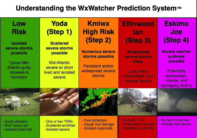
Given that there is a tiny chance at something next week, we'll go ahead and open up the 2023 iteration of the thread. I doubt it will amount to much of anything (perhaps a better chance in the Carolinas and far SEVA) but we'll see. General mid to long range discussion can go in here, as can discussion about past events etc. In past years this has also served as a bit of an "on the fly" obs thread for events that are too small to warrant a separate thread. Pretty casual rules in this annual thread. Looking forward to our usual folks And as always - attached is the @WxWatcher007 tier system for our severe threats here in the Mid-Atlantic subforum.
- 2,785 replies
-
- 9
-
-
-
- severe
- thunderstorms
- (and 3 more)
-
Carver's spoke of creating an early winter spec thread recently, and after another day in the 70s in August, I figured why not get the ball rolling. This for general long term talk about the potential winter patterns, etc. Right now, the EPO has went negative, it's at -12, and is in the East descending phase. In 2021-22 it fell into the negative in May and stayed deeply negative until the following May. So it should descend throughout winter. Below, average pressure anomalies over NH when the QBO is negative. Higher in the PNA/NAO region, lower over the south and eastern U.S. (These maps may initially appear confusing, since they greens are positive numbers. It just means that the they are higher by those margins over those areas or lower by those margins over those areas when there isn't a -QBO in place. Just keep in mind green = lower pressure and cooler temps during -QBO years) There tends to be higher pressure over the North Pole during a -QBO, which results in a weaker jet stream/polar vortex on average. During an El Nino/-QBO combination our forum region is slightly BN for temps DJF and pressures are quite a bit lower across the Southeast (our storm track). The map doesn't look unlike this for temps, but BN for Texas, Tennessee, North Carolina and up the east coast is more prominent than the CPC map here. Especially over Texas.
-
Thought this one was fired up already since fall started a couple weeks ago. Just realized I was posting in the spring/summer thread still. Of course love to keep winter storm obs in the storm threads for later reading all in a single thread. But these are good for daily obs or notable events outside the storm threads. That said, I hit 47.3 this morning after a day time high of 69 degrees yesterday. Pretty similar temperatures for this same period in September 2015 when we got a nice first cold front of the season on 9/13 and had two days of great temps. It was 70/46 on 9/13 and 66/43 on 9/14 that year. Current temp is 71 degrees here, sunny. It was 72 about an hour ago but dropped back a little. In 2015 we never got back above the 84ish range after the front. It had been in the upper 80s for days on end leading into it.
-

March 2nd Moderate Risk ArkLaTex
Ed, snow and hurricane fan posted a topic in Central/Western States
After today's significant Oklahoma outbreak (a derecho and SigTors), March 2nd already 30%. Thursday afternoon and evening look severe-ish. -
 There is likely going to be some warmth during mid-month - and maybe extreme. So, I am not starting this thread w/ any sugar coating. That said, models are sniffing out a cold shot to start this month which wasn't seen on some modeling even 24 hours ago. In life we go one day at a time. Let us not borrow the troubles of tomorrow until they arrive. 12z Yesterday and 12z today of the GEFS.
 -
Mid February is usually when the early peeks at severe can sometimes start showing up. Judging by the models and the long range thread, looks like maybe a marginal threat for Thur night? General severe discussion, remembering past events, and all that usual stuff that goes in here each year can go in here again. Hopefully we get some good thunderstorms this spring and summer. Looking forward to plenty of copy and pasting from @yoda, downer posts from @Eskimo Joe, great analysis by @high risk, and plenty of sun obs that turn into nothing. Giddy up! And for humor sake - see below

-
Looking into the near future it looks like we will see a few shots of colder air and some more cold mornings with frost and possibly a freeze. Really the daytime highs will be perfect.
- 310 replies
-
- 2
-
-
- late freeze
- warm
- (and 3 more)
-
There is a great competition called Virtual Storm Chase that has been given new life (for bragging rights only). This is the same competition that was started over on the old wxchat forums several years ago (mid 2000s). For those that do not know what it is, I have a attached a PDF copy of the rules below. It is a great learning experience for those interested in severe weather forecasting and a great way for even meteorologists to keep sharp. http://virtualstormchase.info The site "appears" to be broke ... but once you register (free) and login it works. Rules: Rules _ VirtualStormChase.pdf
-
Not much has changed. It is starting to look as if the warm sector will continue East in active form. Could see a multi day severe weather outbreak from the Plains to the Ohio Valley/dixie alley. People in KS, OK, MO, and AR really need to be paying attention to this. Original blog post on this: http://www.americanwx.com/bb/index.php/blog/8/entry-95-early-week-plains-severe-threat/
-
Looks to be a significant severe weather threat early next week. An area of low pressure is expected to develop and move off the Rockies … as usual with upper level energy approaching/crossing the Rockies. Ahead of this system, there will be an extended period of northward return flow off the Gulf of Mexico … setting the stage for a moist and unstable boundary layer as our system moves in around Monday. A dry line will develop across Western parts of Kansas, Oklahoma, and Texas. As the dryline moves East, forcing (dryline and upper trough) looks to become sufficient for the development of thunderstorms within moderate to large instability and long/open hodographs. If things hold, would likely be a moderate or high risk day from SPC … with violent/strong long track tornadoes possible across parts of Oklahoma and Kansas.
-
While still being a day 5ish event, it is not to early to start looking at some of the possible implications of various models. At this juncture, we generally have the GFS and the Euro book-ending a possibilities window that includes a cutter to Chicago and a more suppressed system that goes East of Hatteras For the most part been consistently left of the GFS ... with its ensembles a tad to the right of the operational Euro (but no where near the GFS). The 12z GFS Ensembles cut the difference with somewhat of a middle ground ... bringing the primary low into Ohio, with a coastal transfer. Depending on the amount of moisture return that is achieved in the warm sector, the operational GFS could be a notable severe weather event. And would keep QPF amounts across the DC/NOVA area on the light side with little possibilities for winter weather. The transfer with this solution simply happens too late to provide the lift for precipitation and wraparound of cold air. Then we have the Euro with it's more southern solution. It would mean a smaller spatial window for severe weather possibilities and a better chance for wintry weather for the area (especially west ... like we saw with the early March event). Given the time range and the placement of the the ensembles in the middle of the operationals I would expect to see some compromise towards the middle in terms of track over the next 1-3 days ... rather than an extreme on either side verifying. If I had to pick a solution verbatim from this mornings 12z suite for the heck of it, it would be the GEFS.
-

Possible Plains & MS River Severe Weather Episode Next Weekend
thunderman posted a blog entry in thunderman's Blog
Some type of severe weather threat is appearing more likely around the Saturday time fame from KS down into northern TX as a low develops on the flat side of the Rockies and works to setup/organize a dry line and triple point region. As the system pushes east, there is the potential to have a respectable cold front kicking into a moderately to highly sheared 60F+ Td warm sector along the MS River/Dixie Alley. Obviously too early to start boarding the train, but there is def potential for this system to produce a multi-day severe weather event ... possibly an outbreak ... from the Rockies east towards the MS River. Crappy moisture return is the biggest thing that could easily bust the event IMO. -
Evening/Overnight Tornado Threat in MS River Valley Region
thunderman posted a blog entry in thunderman's Blog
Eventual tornado threat will depend on how unified the current line of storms becomes. If it can manage to maintain some semi-discrete updrafts within the line, then all current data points towards a significant nighttime outbreak across AL/northern LA/western MS. The combination of boundary parallel upper SR winds and low level SR winds on the order of 20-40 knts has me personally a little worried about a too unified squall line ATTM for a significant tornado threat. Some guidance manages to keep the southern end a little less unified enough that it overlaps with favorable hodograph environments ... so around the LA/AR border area may end up being ground zero for this event. -
An area of low pressure with move out of the plains and up to our Northwest. As it passes by, it will drag a fairly healthy cold front across the area Wednesday afternoon/evening. It is only January but strong winds just off the surface leading to strong shear, a good quality warm sector, and linear forcing with the front may be enough to trigger a strong to severe line of forced convection along the cold front. The primary threat would be damaging winds and heavy rainfall with PWATS possibly exceeding 1.5".


