Geoboy645
-
Posts
708 -
Joined
-
Last visited
About Geoboy645

Recent Profile Visitors
5,877 profile views


-
Pretty incredible stretch of temperatures coming up for Mid-April. We have had warmer, and similar length stretches of warmer temps. But having 70s and humid for at least 5 days straight is impressive, as usually it's dry when we get warm for that long this time of year, ala 2023. Going to be stacking up the rain totals as well, especially if areas have multiple rounds of T-storms. Could be a significant flooding issue in the UP and basins coming off of that area and the North Shore where there is still a significant snowpack. GRB has noted the possibility of the Menominee River reaching moderate or major flood stage later in the week. That plus the multiple severe days is going to make it a very busy week for the region.
-
Yeah we are probably in the 3-4" of rain range as well over the last few days up here. A lot of the usual spots are starting to get into action or minor flood stage, except Ontario on the Kickapoo which is somehow in major stage. Next week's system is going to be something to watch for flooding, as it's going to take a few days for everything to dry out. And just like that we go from worrying about drought to flooding. Again.
-
Event is already about to be underway here. But there should be a thread for a 10 percent and a 70/40 watch.
-
I'm in short sleeves at 930pm in March. Less than a week after having a historic blizzard. What a strange month, even for March. It's frankly kind of unnerving just how warm it is outside rn.
-
We went from 70 degrees on March 9th to 40-50mph winds on March 13th to freezing rain on the 15th and 10 inches of snow on the 16th to 25 and sunny on the 17th and now 63 degrees yesterday and a forecast of 70 today. One of the craziest March rollercoasters for temps we have had it feels like.
-
Looks like we ended up somewhere in the 10" range here. Very hard to tell exactly how much because of the drifting though. Sun is starting to peek through here, although we still have several hours of blowing snow to go before it finally calms down. Will be interesting to see how long this snowpack lasts both around here and in the extreme totals up north. With 3/25/23 it took about 5 days to melt everything but the largest piles. But that was a bit later in the year and a wetter snow with some rain as well on top of it. We are supposed to hit the 50s by Friday, but we will see how much the snowpack reinforces the cold air even with March sunlight. Crazy to think that this is about the same amount of sunlight that we had when were in the upper 80s in late September last year. All in all, a very memorable storm for the state of Wisconsin and one that will be talked about for a while like the 2018 storm.
-
Milwaukee has officially put a blizzard warning now. First one since 12/20/12 here.
-
Wausau still looks like the winner so far with 24 inches reported around 2 a few miles west of town. With the defo band still to come they may get to 30+ before it's all set and done.
-
Yeah the trees are starting to get the freezing rain look right now. This could be an issue once the change over happens and the wind starts to pick up.
-
Yeah I think we are going to have changeover sooner than expected here.
-
Always has been one of those events though?
-
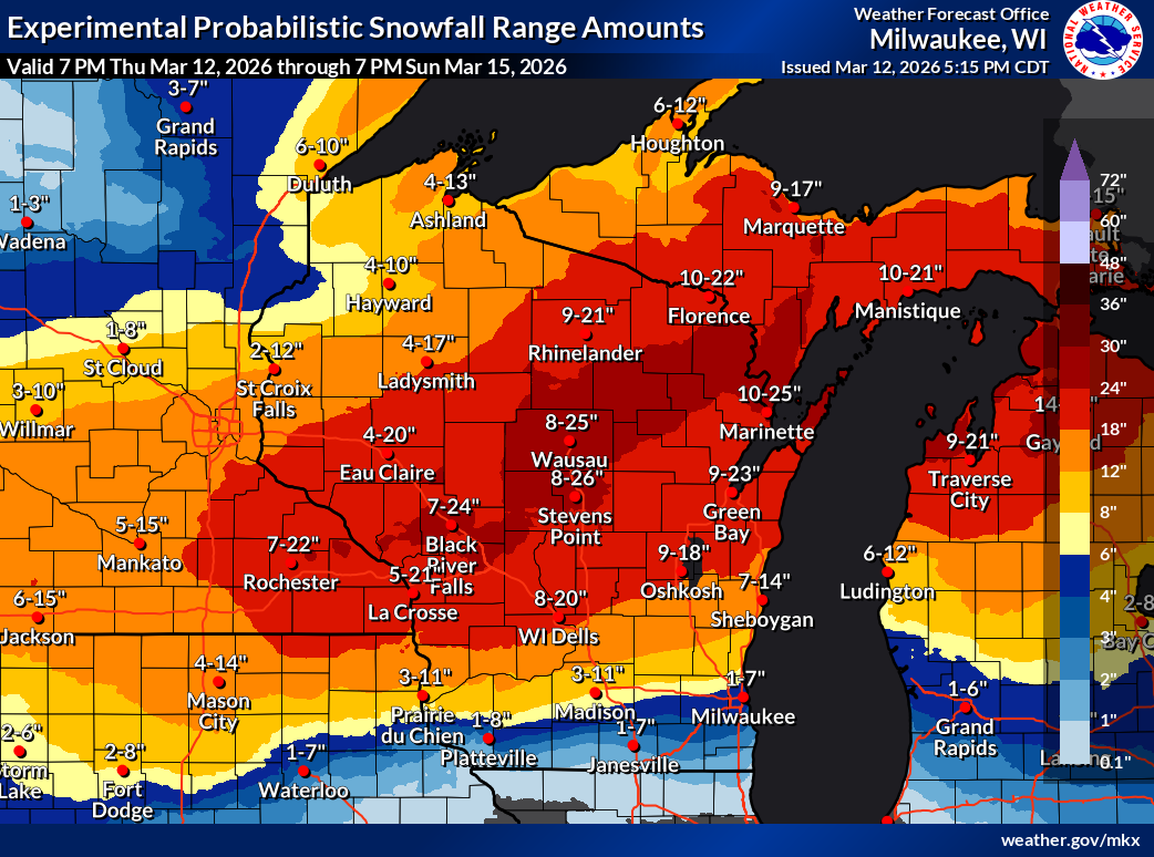
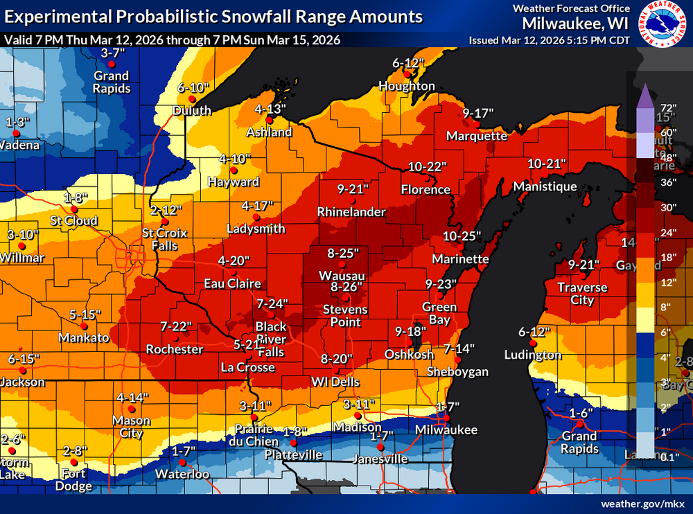
Well the probabilistic forecast is out through Sunday N and hoo boy. Normal caveats with this and some of that is affected by tonight's clipper. And it's still snowing probably another 12 hours after the end of the period on the map.
-
So interesting fact, the high wind warning issued for tomorrow is only the 7th one on record for Columbia County according to IEM. 12/15/21, 2/24/19, 3/8/17, 3/16/16, 2/21/14, and 10/26-27/10 are the only other times that we have had one issued. I knew they were rare here, but I didn't realize that rare.
-
On one hand, it feels kind of early for Winter Storm Watches. On the other hand, we are only two days out from the storm with one of the strongest synoptic wind events in years here tomorrow during the day. This one is going to catch some people by surprise, especially after Monday's warm temps so I'm not surprised that they went with them as soon as they could.
-
If that most recent run of the Euro is to be believed, some of those areas that get over half an inch in WI and MI get 6-12 or more inches of heavy wet snow on top of it with the wind. If that happens, that would be catastrophic, including in some areas that were affected by last year and yesterday. I would rather have the straight 20 inches of snow here than deal with ice and then snow like that.