-
Posts
577 -
Joined
-
Last visited
Content Type
Profiles
Blogs
Forums
American Weather
Media Demo
Store
Gallery
Everything posted by Geoboy645
-
SPC has introduced a Day 4 15% across IA/IL/WI all the way to the UP Border.
-
The models within the last couple of days have really honed in on a potential multi-day severe and heavy rain threat over this weekend over the western part of the forum. With a particular focus at this point on Friday in IA for severe and a heavy rain event over the Upper Mississippi Valley for the weekend. Considering how wet it has been in that part of the forum for the last month and a half, there may be some flooding concerns as we get closer. Could be a very busy weekend here in the Midwest.
-
Yeah up here at least our forecast doesn't drop close to 32 all week. Coupled with all the recent precip and sunny days later in the week, everything should be going nuts for green up by the end of the week.
-
4/2-4/3 Significant Late-Season Snowstorm (WI/MI)
Geoboy645 replied to Geoboy645's topic in Lakes/Ohio Valley
We maxed out at about 5 inches on the ground around midnight on Wednesday. We switched to mix after that and we only had about 2 inches after that. One thing about this though is how wet it is here now. We went from basically no puddles when it rained two weeks ago to now puddles everywhere on the lawns and sidewalks. GRB has had 1.36 inches in the last three days and 2.76 inches in the last three weeks. Talk about a turnaround here -

4/2-4/3 Significant Late-Season Snowstorm (WI/MI)
Geoboy645 replied to Geoboy645's topic in Lakes/Ohio Valley
It's been pretty gnarly so far here in GRB. We had thundersnow about 2 hours ago that I unfortunately did not hear. The wind has really picked up and we have I would say 3-4" on the ground. I think we have transitioned back to mix here as well though, although it is hard to tell. If we have transitioned back to mix, that could cut down on our totals however. Either way it is a slushy mess outside rn. -

4/2-4/3 Significant Late-Season Snowstorm (WI/MI)
Geoboy645 replied to Geoboy645's topic in Lakes/Ohio Valley
We fully switched over to snow about 2 hours ago. It has been heavily coming down since, with probably 1-1.5 inches or so accumulation so far on grass. Green Bay officially has us at 8-12" for snowfall, with 12-18 further N. What an escalation considering 48 hours ago we were talking snow showers. It's going to be a long night here in Green Bay. -

4/2-4/3 Significant Late-Season Snowstorm (WI/MI)
Geoboy645 replied to Geoboy645's topic in Lakes/Ohio Valley
-
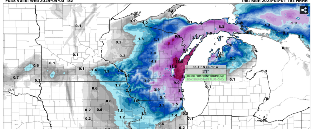
I figured this needed it's own thread at this point. So the models over the last 24 hours have really come into agreement that tomorrow into Wednesday across Wisconsin and the UP. Some models like the 18z have over 20 inches (!) of snow on the Ledge by this time Wednesday afternoon, and it's still snowing. Which is absolutely insane. There's also the potential for up to 50mph gusts during this event as well. And with the lake being completely open and warm for this time of year, there is a decent chance of lake enhancement off of Green Bay. If that happens, then the sky is the limit for potential in the Fox Valley with this storm in my opinion.
-
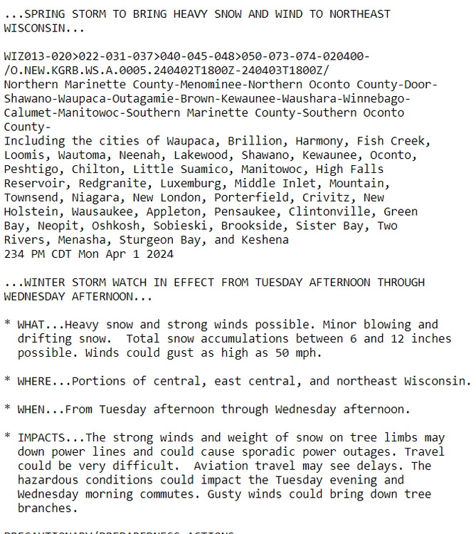
It's already starting to snow a little bit here in Green Bay. GRB has issued a winter storm watch for tomorrow and Wednesday for it's eastern half and this is pretty strong wording considering the low lead time for this. This is really giving me the same vibes as 3/25 last year. Large area of snow, with a death band that we don't really know where it's going to set up in the event is underway. And this time, there's going to be a hefty wind component to it. Green Bay may legit get it's second foot plus storm this year which is insane considering the rest of the winter.
-
....wait what...
-

Spring/Summer '24 Banter and Complaint Thread
Geoboy645 replied to IWXwx's topic in Lakes/Ohio Valley
I'd say this winter was a C- here. The theme of this winter was what it wasn't doing for really all but two weeks. Basically no snowcover, consistent temps in the 30s and 40s, and two double digit positive monthly anomalies. A green Christmas with 50s and rain, and oh yeah a sigtor on February 8th (!). However, the two weeks that were wintry were one of the more intense winter periods we have had in the last 5 years. Probably number 3 after the last week of Jan in 2019 and the two weeks in Feb 2021. Over 20 inches of snow followed by a week in the single digits is pretty intense no matter what the winter is. And that snowpack was extremely solid. Even with the constant 40s after the period, it still took over two weeks for the snowpack to melt. If it was a normal winter we might just now be finishing off that snowpack. So I can't really go too low with the score because of that. Hence, my score of a C-. -
You could say that yeah. So much for those futility records lol.
-
Yeah the consistent signal for the beginning of a stormy period has been nice to see the last few days. What's not been so nice is the signal that at least some of that precip could be of the frozen variety especially in the N of the forum. But precip is precip, and basically everywhere can really use some right now no matter the type.
-
According to Xmacis, looks like April 6th, 1912 is the latest Minneapolis crossed the 1" mark for the year. Interestingly enough, that was also a Nino albeit it only got 1.4 instead of 1.8 departure. The difference however is that 1911-1912, especially January 1912, was one of the coldest winters ever for the Midwest. Like Minneapolis averaged a *checks notes* -18.9 departure for the month in January (!). Quite the opposite of this winter to say the least.
-
Yeah if we don't have a wet March then we are going to be in big trouble across most of the Upper Midwest. We really didn't recover from the drought all that much even in the wetter areas last fall. Combine that with the no frost and snowpack and we are already about 2-3 weeks ahead arguably from an evapotranspirational standpoint. I have some serious concerns especially for MN and the Northwoods where they didn't even get the snow in January.
-
Well we ended up with a nice 2-3" of snow from this storm. Classic mid-March storm with the rain at the beginning last night and then turning over into slushy snow overnight. Its become sunny now and the snow caked on the trees is really pretty right now before the sune melts it. Will have a nice cooldown into the 20s the next couple of days, but right back to average in the upper 30s and 40s on Sunday. Talk about a perfectly stereotypical mid-March pattern....wait what do you mean its February 15th?!
-
Honestly at this point, I don't know if I really want anymore significant cold and snow. The warmth and rain yesterday felt really nice, and there are already the beginnings of some of our early spring plants coming up. I've frankly forgotten that it is in fact early February a few times. We've had our cold and snowy stretch, and a pretty high end one at that. Let's get an early, warm, and drawn out spring in for once. I know that we will get cold and snow still, especially with the incoming SSW. But man, this stretch has been really nice.
-
In other news. With the warmth yesterday. GRB is now up to a +17.1 (!) departure for the month. And that's probably not going to come down to earth all that much in the next 5-7 days going by the point forecast. Even if we had a repeat of the Mid-January cold wave, and that's not looking likely at all, we'd still be talking about probably at least a +5 anomaly for the month. We have to be pretty much locked in for at least a top 15 if not top 10 warmest February at this point.
-
Yeah we only got like 4 inches of snow from GHD II at least in the Madison metro and points north. It was a pretty ho-hum snowfall for us. It's why Feburary 15 as cold as it was doesn't really stick out as much as other similar months.
-
The most significant part there are the lows. They went from December 8th to January 30th without a low lower than 20. That's equivalent to like early April for lows for almost 2 months in winter. No wonder stuff was greening up and growing.
-
MKE always runs warm relative to the surrounding area during winter because of the proximity to the lake. General Mitchell is within a couple miles of the lakeshore. Compare that to Midway or ORD where they are like 10 miles away from the lake. As we all know, that makes a big difference. See the 1/12 snowstorm where MKE only recorded 8 inches of snow while areas just to the west, at about the same range as ORD and MDW, measured over a foot. This is why MKE isn't really the best measurement site to use as a proxy for the entirety of the Milwaukee metro IMO. However, there really isn't another good one unfortunately.
-

Winter 2023/24 Medium/Long Range Discussion
Geoboy645 replied to Chicago Storm's topic in Lakes/Ohio Valley
To put it in perspective, before the cold blast Madison was running a +9 departure for the month. Even with all the cold of last week the lowest the departure got was ...-1.... Now with the warmth from a couple days ago to the end of the month its shooting up again. We are now back to exactly 0.0, with the next 6 days above to well above average. -
That whole stretch from the 1877-78 Nino all the way until like 1890 was just a wild 15 years in the Midwest. Madison had a similar snap back and forth in record warm and record cold winters in that stretch. Including what was likely our snowiest winter ever in 1880-81 if the precip totals from melted snow are to be believed. Also 1880-1885 was our wettest 5 year stretch ever until arguably 2015-2020, with what is probably one of if not the biggest flood in state history in June 1880. The Wisconsin River had a flow of over 100,000CFS at Wisconsin Rapids, the only gauge with records that far back. Later on 1887-88 was a record snowy year further north in Green Bay, where they recorded almost 150" of snow that winter, and then followed up with 120" two years later in 1889-90. The next snowiest year is "only" 93.5" in 2010-11. We really didn't have a crazy stretch like that again in regards to precip and snowfall totals and whiplash really until the late 2000s, and its been like that ever since.
-
Final total map from MKX. Pretty good verification for MKX and the models as a whole. We were pretty much locked in for at least these totals from like Wednesday morning no matter what the trend was, so to have that verify was very nice. We probably have about 14-15" of snow OTG between the two snowfalls this week. And now with this little clipper coming in the temps have really started to drop. Low clouds with peaks of sun, snow blowing around and lightly falling, and the wind blowing. It is positively arctic out right now. Since I wasn't around here for Feb 2021, this is the most "deep winter" conditions I've experienced since late Jan 2019.
-
Also fun fact, because of the snow wednesday night occuring over midnight. Madison now is on a 3 day stretch of recording over an inch of snow, which is already the 6th longest on record. We will definitely get 4 today and most likely get 5 tomorrow. Which would tie the stretch from 12/15/74-12/19/74 for the most consecutive days with an inch or greater snowfall on record.


