-
Posts
708 -
Joined
-
Last visited
Content Type
Profiles
Blogs
Forums
American Weather
Media Demo
Store
Gallery
Everything posted by Geoboy645
-
Pretty incredible stretch of temperatures coming up for Mid-April. We have had warmer, and similar length stretches of warmer temps. But having 70s and humid for at least 5 days straight is impressive, as usually it's dry when we get warm for that long this time of year, ala 2023. Going to be stacking up the rain totals as well, especially if areas have multiple rounds of T-storms. Could be a significant flooding issue in the UP and basins coming off of that area and the North Shore where there is still a significant snowpack. GRB has noted the possibility of the Menominee River reaching moderate or major flood stage later in the week. That plus the multiple severe days is going to make it a very busy week for the region.
-
Yeah we are probably in the 3-4" of rain range as well over the last few days up here. A lot of the usual spots are starting to get into action or minor flood stage, except Ontario on the Kickapoo which is somehow in major stage. Next week's system is going to be something to watch for flooding, as it's going to take a few days for everything to dry out. And just like that we go from worrying about drought to flooding. Again.
-
Event is already about to be underway here. But there should be a thread for a 10 percent and a 70/40 watch.
-
I'm in short sleeves at 930pm in March. Less than a week after having a historic blizzard. What a strange month, even for March. It's frankly kind of unnerving just how warm it is outside rn.
-
We went from 70 degrees on March 9th to 40-50mph winds on March 13th to freezing rain on the 15th and 10 inches of snow on the 16th to 25 and sunny on the 17th and now 63 degrees yesterday and a forecast of 70 today. One of the craziest March rollercoasters for temps we have had it feels like.
-
Looks like we ended up somewhere in the 10" range here. Very hard to tell exactly how much because of the drifting though. Sun is starting to peek through here, although we still have several hours of blowing snow to go before it finally calms down. Will be interesting to see how long this snowpack lasts both around here and in the extreme totals up north. With 3/25/23 it took about 5 days to melt everything but the largest piles. But that was a bit later in the year and a wetter snow with some rain as well on top of it. We are supposed to hit the 50s by Friday, but we will see how much the snowpack reinforces the cold air even with March sunlight. Crazy to think that this is about the same amount of sunlight that we had when were in the upper 80s in late September last year. All in all, a very memorable storm for the state of Wisconsin and one that will be talked about for a while like the 2018 storm.
-
Milwaukee has officially put a blizzard warning now. First one since 12/20/12 here.
-
Wausau still looks like the winner so far with 24 inches reported around 2 a few miles west of town. With the defo band still to come they may get to 30+ before it's all set and done.
-
Yeah the trees are starting to get the freezing rain look right now. This could be an issue once the change over happens and the wind starts to pick up.
-
Yeah I think we are going to have changeover sooner than expected here.
-
Always has been one of those events though?
-
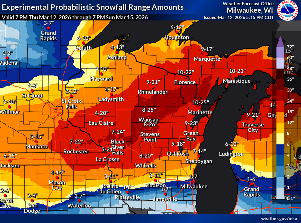
Well the probabilistic forecast is out through Sunday N and hoo boy. Normal caveats with this and some of that is affected by tonight's clipper. And it's still snowing probably another 12 hours after the end of the period on the map.
-
So interesting fact, the high wind warning issued for tomorrow is only the 7th one on record for Columbia County according to IEM. 12/15/21, 2/24/19, 3/8/17, 3/16/16, 2/21/14, and 10/26-27/10 are the only other times that we have had one issued. I knew they were rare here, but I didn't realize that rare.
-
On one hand, it feels kind of early for Winter Storm Watches. On the other hand, we are only two days out from the storm with one of the strongest synoptic wind events in years here tomorrow during the day. This one is going to catch some people by surprise, especially after Monday's warm temps so I'm not surprised that they went with them as soon as they could.
-
If that most recent run of the Euro is to be believed, some of those areas that get over half an inch in WI and MI get 6-12 or more inches of heavy wet snow on top of it with the wind. If that happens, that would be catastrophic, including in some areas that were affected by last year and yesterday. I would rather have the straight 20 inches of snow here than deal with ice and then snow like that.
-
Arguably this storm has actually had a high amount of agreement of models for this far out. We know that somewhere in WI is going to get hit with a very significant amount of snow and have a rough idea of what that corridor is most likely going to be. That's pretty good for 3-4 days out all things considered.
-
Yeah it's been a good winter here. Had the fast start like everyone else, but had that very localized 10 inch snow in mid January right before the cold blast that gave us snow depth for it. However, I do not care for some of these solutions to say the least. Two feet of fluffy cement snow and wind is bad, very bad.
-
Some of the model runs are uhh something for this area that's for sure. There is definitely a lot of moisture around to the S so I am not totally discounting higher totals. A late major snowstorm is a pretty typical thing around here in a transitioning Nino spring. With the recent notable examples of 4/13-15/18 and 3/25/23. However, being so warm ahead of said storm is unusual. Could be a very interesting start to next week here.
-
That seems to be the pattern most of this decade with the exception of the first half of 2024, at least here in S WI. Long periods of nothing interspersed with about 6 weeks of precip and storms, followed by another 2-3 month stretch of nothing. Hopefully we can get enough precip in the Spring this year.
-

Winter 2025-26 Medium/Long Range Discussion
Geoboy645 replied to michsnowfreak's topic in Lakes/Ohio Valley
Yeah outside of the 11/30 snowfall and a rain event in early January we haven't had a significant precip event essentially since mid August. Hopefully this incoming active Pacific pattern has some widespread precip events in the next few weeks otherwise we are going to have some Problems as early as April. Especially if we have another Smoke Drought in May and June like 2023 which is a distinct possibility this year. -
Yeah I am concerned about getting a warm precip event on top of this snowpack. Especially in the Ohio Valley where there's a higher chance of them being in a rainy warm sector and there's a recent history of significant heavy rain in February. There's a general 3-9 inch snowpack over the region with deep frost and frozen streams. It doesn't even take that much rain or snow on the ground to have a major flood. Nebraska in 19 only had a few inches of snow and like and inch of rain. The region has had bad experiences with that type of flood before, notably in 1913 and 1936. Even up here anything like the March 19 warm sector and we have problems as well.
-
Yeah here at Madison its easily been the coldest and snowiest first half of winter in a while. Even with the Christmas warm wave and first week of January. We are at 38 inches of snow so far at the airport with about 12 of that over the last week. That's a total that's only been "recently" surpassed by years like 07-08, 08-09, and 00-01. We have a general 3-7 inches of snow OTG. Pretty good start to say the least.
-
What was originally looking like a pretty standard cold wave for mid January has now become a potentially very significant cold wave for the region. Model runs are showing sub zero highs for at least the northern parts of the subforum on Friday and potentially Saturday. And some runs like the most recent GFS have daytime highs on the level of the 94,96, and 19 cold waves at least N of the IL-WI border which is extremely impressive without widespread deep snow cover. We have already had sub -30 wind chills and sub -5 daytime temps here today, and if we don't cross 20 on Wednesday we may have at least 10 days straight of sub 20 highs.
-

Winter 2025-26 Medium/Long Range Discussion
Geoboy645 replied to michsnowfreak's topic in Lakes/Ohio Valley
Yeah this cold blast could be significant from a duration perspective. Nothing super crazy for temps, but we could be talking at least a week of sub 20 highs if we undershoot Wednesday by a couple degrees which is possible with the fresh snowpack. The Holiday cold wave was sub 20 for 12 days here so that's the modern mark for duration of a cold wave imo. -
Meanwhile here around Madison, we just had one of most localized snowfall events we have had in a while. The original forecast for Friday into Saturday was 1-2" Friday morning and then another Friday night. Instead we had a localized Fgen(?) band setup Friday night over the I-94 corridor and just sit for about 18 hours. With some occasionally heavy rates of 1-1.5" of an hour, Madison ended up recording 5" of snow on 1/16 and 5.6 on 1/17, although the snow depth doesn't quite represent that because of settling.. This was a very dry and fluffy snow too, so we could have localized ground blizzard like conditions tomorrow with the cold blast. Thing is, this band was not much wider than Dane County. I have some snow up here, but like 3-4" not 6+. And if you go N to Portage or S to Janesville they may have like 2-3 OTG. This honestly feels like a summer MCS that forms and doesn't move and dumps 5-6" of rain in a night, but just snow instead.


