Geoboy645
-
Posts
714 -
Joined
-
Last visited
Content Type
Profiles
Blogs
Forums
American Weather
Media Demo
Store
Gallery
Everything posted by Geoboy645
-
Well the clipper that passed through today dropped a localized band of 1-3" across the area. Nothing crazy, but combined with the snow from last Thursday, we should have enough of a snowpack to get a White Christmas this year. Unfortunately it's going to all melt later in the week with the incoming 40s, but at least it actually lasted to Christmas and didn't melt right beforehand like previous years.
-
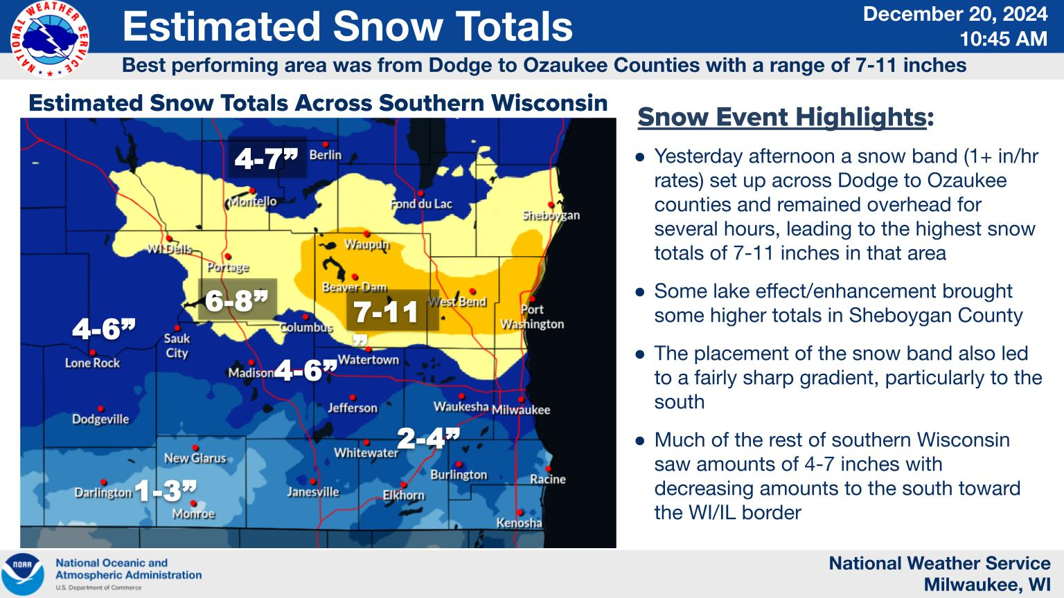
So we ended up well overperforming with the clipper yesterday here. At home Id say we got about 7" here. It actually looks like December outside for once. This is the first time it has looked like this out on Dec 20th in many years. And our first significant clipper since at least 21 if not earlier. Too bad it's supposed to get warm before Christmas, because this would be a perfect snowpack for the holiday. Although we do have enough that we should have at least some OTG for the holiday.
-
This is looking to be a pretty significant clipper event for the northern areas of the subforum. Even down here we could get 3-5" of snow from this thing tomorrow into Friday. Our first real significant snow event of the year, and our first significant clipper in a long long time.
-

Winter 2024-25 Medium/Long Range Discussion
Geoboy645 replied to michsnowfreak's topic in Lakes/Ohio Valley
Meanwhile, back to our regularly scheduled December programming. Guess it'll be yet another Christmas in the 40s/50s for the Midwest with that look.
-
November 2024 General Discussion
Geoboy645 replied to SchaumburgStormer's topic in Lakes/Ohio Valley
Yeah if we could do this flurry/mood flake pattern with actual snow OTG over Christmas Eve/Day that would be great. -
November 2024 General Discussion
Geoboy645 replied to SchaumburgStormer's topic in Lakes/Ohio Valley
Yeah it's been flurries since like 11 here from that plume. We have actually accumulated a dusting from it, which is cool I guess. This happens a few times a winter here with the right conditions. Iirc a few years ago we had a sustained stretch with more favorable conditions and we actually got like an inch of just power plant effect snow. -
November 2024 General Discussion
Geoboy645 replied to SchaumburgStormer's topic in Lakes/Ohio Valley
In other news, the rain and snow the last week here has bumped 2024 up to #4 all time for precip at Madison with 47.23 inches. The only years ahead of 2024 at this point are 1884, 2018, and 1881 with 49.19, 50.64, and 52.91 inches respectively. I think we can surpass 1884, and mayyybe 2018 if we get a QPF bomb at some point in the next month. I don't think we reach 1881 at this point unless something very strange happens, especially with the incoming cold/dry NW pattern. Although, at least yesterday we continued the overperformance streak at least further to the east. An area of Dodge County from Beaver Dam Eward got 6" of snow, which is definitely an overperformance. It'll be interesting if the streak continues as we start winter here.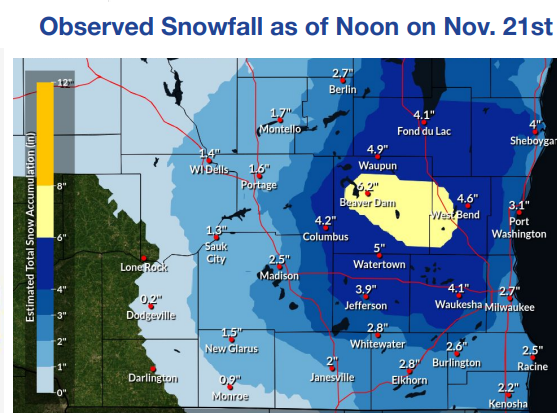
-
Winter 2024-25 Medium/Long Range Discussion
Geoboy645 replied to michsnowfreak's topic in Lakes/Ohio Valley
Yeah this feels like the pattern that we have managed to somehow avoid the last few years where the LES belts just go on overdrive, for everyone in the belts. We've seen how it's been for Buffalo with the well-above average water temps (LSTs?) and favorable cold air and wind direction. We haven't seen that with a NW-flow event in quite a while while the lakes have been at the early season max for temps. Will be interesting to watch over the next couple weeks here. -
The way we have been overperforming rain events this year and have had two inch rain events this year, there's a chance we'll be above average by like Tuesday.
-
So Madison finished yesterday with a total of 2.21 inches of rain. Making it the 5th 2 inch plus day at Madison this year, tied with 2000 for the most ever. Making this year a top 10 wettest year on record with 43.60 inches and counting, probably will surpass 08 and 07 by the end of next week. And making this month combined with the .28 so far today, an average month of precip which is just hilarious. The whiplash of 2024 continues.
-
What, a rain event overperfoming? In the year 2024? That's so crazy!
-
An impressive stat about yesterday. The average of the day ended up at 73.5 degrees at Madison. It beat the latest daily average above 73 degrees by 8 days. The average date of last day this warm is September 11th, so yesterday broke that average by 48 days(!). To put it in perspective, in spring the earliest date this warm was April 16th, and the average first day this warm isn't until May 26th. The significance of a daily average of 73 at Madison is that it's warmer than the 30-year daily average for the average temperature of the warmest stretch of summer from July 2nd to 30th. So even in the peak of summer, a daily average of 73.5 would be considered an above-normal day. And we had a day with that on October 29th. That's pretty crazy.
-
Madison reached 81 today, tied with 10/29/1937 for the latest 80 degree day on record.
-
Fall/Winter '24 Banter and Complaints Go Here
Geoboy645 replied to IWXwx's topic in Lakes/Ohio Valley
https://x.com/BenNollWeather/status/1845213325338214901 Well if this is any accurate, pretty bad. If that holds true, things could get rough for drought across the region come spring. -
Drought Monitor updated, and it is starting to look really rough for the areas that have missed out on the last couple of events. The Northwoods especially is looking rough, that's a large area of D2 added this week with no real precip chances in sight. Definitely an increased chance of wildfires up there as we continue on into October and November.
-
Despite it not really feeling like it, it is in fact October. Nothing really too exciting in the near-future, just continued 60s/70s and sunny for the region. As long as we can keep these conditions for the comet from the 9th-20th, we'll be alright. Biggest concern for the first half of the month otherwise is the continuing drought conditions in the areas that missed out on the rain on 9/22 and/or from Post-Helene, especially in the Northwoods where it has been pretty dry for a while now. Otherwise, not a whole lot going on.
-
Looks like the final total will be 3.97" for today at Madison. Breaks the daily and monthly record set on this date in 2009, and is a top 5(!!!) daily rainfall in Madison. This feels like the rain equivalent of 3/25/23 where nothing was really expected to happen and we end up with a top 10 daily precip-type record.
-
Madison is up to 3.20" for a daily total so far, with a few more hours of rain to come. This makes this year one of only four years to record multiple 3"+ days in year with 1869, 1878, and 2007 being the other ones. This also puts us over 40" of rain for the year, which makes this year a top 15 wettest on record. Notably before 1990, we only recorded 40" of rain in a year in the 1880-85 period and 1959. And now this is the 8th time in the last 34 years that we have recorded 40"+. We have recorded almost as much rain since Midnight as we had recorded in the over two months prior. Crazy.
-
Welp, I guess the drought is over up here. Widespread 1-3" over most of Southern Wisconsin, with pockets of 4"+. Including an area of up to 6" (!) between Rio, Dekorra, Wyocena, and Poynette. It can't ever just be a little rain anymore, it either has to be no rain at all or a major rain event.
-
2024 Short/Medium Range Severe Weather Discussion
Geoboy645 replied to Chicago Storm's topic in Lakes/Ohio Valley
Today feels like June or July 21st, not September 21st with the afternoon popup-style, and occasionally severe storms. Very strange feeling to say the least. -
To put in perspective how much of a flip this has been for precipitation. In the two months from 5/16-7/16, Madison recorded 20.87 inches of rain (11.22 in to 32.09 in). In the two months from 7/16 to today, we have recorded 3.82 inches (32.09 in to 35.91 inches).
-
After experiencing the 5th wettest summer on record, we are now in abnormally dry conditions. Talk about a change.
-
What? We start going well above average again as soon as we leave summer? Color me shocked!
-
Just like that it's September again. The most pleasant month of the year for the region, and at least the first week or so looks to be that way this year. Can't complain about 70's and sunny at all this time of year, as the clock starts to slowly tick down to the beginning of cold season in a month and a half. Notably, the colors and everything getting that September crispness seem to be just a bit ahead compared to normal rn with the mostly cool and dry August. Definitely going to try and enjoy this month.
-
Yeah the next week to 10 days look like a pretty typical early September forecast. No complaints here at all. It'll be interesting seeing how the first part of fall evolves here, as in some ways it already feels like we made the switch from summer to fall conditions even before the heat of the last couple of days. Notably, even with the drier August we are still running at #5 YTD for precip, so it'll be interesting seeing if that continues or not.