Geoboy645
-
Posts
714 -
Joined
-
Last visited
Content Type
Profiles
Blogs
Forums
American Weather
Media Demo
Store
Gallery
Everything posted by Geoboy645
-
It definitely was a shock walking out of work last night into the 86/75 degree air at 8pm with it practically dark out. That's the weird thing about heat like this at this time of year. This is pretty close to the same level of sunlight that we have in early April when we get stuff like 4/2 earlier this year and 4/13/18.
-
Normally a heatwave like this would feel more like a nuisance than anything at this point in the summer, but because we have been so cool for the last like 6 weeks that this is going to be a bit of a shock for a couple days. Cannot complain about the last 6 weeks though, it's been a really pleasant, if boring, stretch of weather.
-

Spring/Summer '24 Banter and Complaint Thread
Geoboy645 replied to IWXwx's topic in Lakes/Ohio Valley
Yeah no real complaints here from a temperature perspective, it's been great! The excessive rain got to be very annoying, but even then that stopped about a month ago. The last month has been one of the better month-long summer stretches in a while it feels like. And the fact is we could go another 2-3 weeks of this at least considering this is pretty much the average kind of weather for September. -
So a blob popped up here after the main MCS moved through and just like that it's dumped another 2-3 inches on top of the prior rainfall and triggered yet another couple of FFWs. Well the dry weather was nice while it lasted.
-
As of rn this is looking pretty similar geographically to Ike's remnants in 2008. With potential a similar intensity in regards to rainfall in some areas. Granted, the wind threat should not be there basically at all unlike Ike. But still, the potential is there for probably the most significant rainfall from tropical remnants in the Midwest since Cristobal, if not Ike.
-
At least that part of the region has been pretty dry this summer so far, so it should be alright for flooding as long as things don't get too heavy. We can't take any of it up here at this point so it needs to stay down there. Although the Mississippi being in flood stage because of the flooding in the upper basin and the Missouri basin could throw a wrench into that a little bit.
-
I am so tired of the rain. Since the flooding on the 22nd and 23rd, we have had a few more rain events, including tonight. While none have caused the amount of flooding as 6/22, everywhere has high water rn. We desperately need a break and it just keeps coming. It doesn't help it's like an inch to two inches of rain everytime. And with today's rain, a bunch of the local fireworks shows got postponed to Saturday. And the forecast continues to look wet. And depending on what happens with Beryl, we could be in for a remnants event sometime later next week. This is what 1993 must have been like, which btw we are currently ahead of rn with precip. Which is incredible, with the caveat that 1993s big flood events weren't until July on WI for the most part. The only reason this isnt fully 1993 is the leftover effects of the drought last year. Which by the way, we have surpassed not only the entirety of last summers rainfall in the last month, some areas by Baraboo and Portage have almost certainly tied or exceeded the annual amount for last year just in the last 60 days. Those areas got around 20 last year and they have had that in the last 60. And the thing is, we theoretically could keep doing this for the rest of the summer. It just never ends.
-
Crazy on a day that was supposed to be on the lighter side we still managed to get that much rain
-
2024 Short/Medium Range Severe Weather Discussion
Geoboy645 replied to Chicago Storm's topic in Lakes/Ohio Valley
I am not enthused by this at all. With how wet our soils are, and how most of our vulnerable trees, being the EAB ash trees, are either still in or have been in water. We are highly vulnerable to significant wind. And with it coming through at like 1am, that could cause even more issues. Even 60mph winds could cause issues tonight, let alone anything stronger than that. -
FFW in effect for a dam failure S of Mankato. The Rapidan Dam on the Blue Earth River has failed after erosion of the earth on its W side. Fortunately it's not that big of a reservoir behind it, but still. Just an incredible amount of water flowing into the Minnesota River rn. In other news around here, the rivers have appeared to have crested, for now. However, with this potential MCS tonight we could have another 1-2 inches, which would be a major blow rn. The rivers are going to take a while to come down as is, and we can't take anymore than maybe a half inch at this point. Even fields on top of hills have water in spots, that's how wet it is. And we still have whatever is going to happen this weekend.
-
So having driven around a bit this morning. Looks like most streams are at least bankfull if not minor to moderate flooding. The Crawfish is a touch below it's crest in March 2019 on Fall River with likely a few more hours of increases at least. Areas that haven't flooded since that or 2018 are flooded rn. There is so much water just sitting on the fields still. The Rock at Waupun is at MDT stage, and Spring Creek in Lodi is at major stage. And the Wisconsin is going to be at flood stage at Portage, so drainage for the tributaries between the Dells and Lake Wisconsin is going to be slower than usual. If we end up with anything more than an inch on Tuesday, we are in serious trouble.
-
It never ends!
-
And just as I say that MKX issued an areal flood warning for the western half of Columbia county citing standing water in Lodi and washouts and road closures. This is going to be a long few days.
-
That is an incredible amount of rain over two days. I estimate we got about another 2 inches from the round tonight. And we are probably in the neighborhood of 4" over the event here. Combined with an inch from Wednesday and we are at over 5 inches for the week. And probably 10 for the month. Luckily this round moved relatively quickly through. But there is just water everywhere rn. The Crawfish is back up to just below where it was on June 4th, and that's before really any response to tonight's rain. We are probably going to have some flooding issues on every one of the quick response type streams in the area. Unfortunately for Marshall and Waterloo, that especially includes the Maunesha. And unfortunately, we may do this all over again for rain on Tuesday and then next Friday and Saturday. 48 hours is going to be nowhere enough time to dry things out before the next round.
-
The corridor along and just N of Hwy 78 from Prairie Du Sac to I 39 is getting slammed according to MKX radar. Radar estimated 3 to 5 inches with more coming. And that is some rough terrain to have that much rain on. Edit: Looks like the max is around Parfreys Glen and Prentice Creek. Both of which experienced major flash flood events in 08.
-
Crazy what a few tens of miles difference makes. We have had like .75 here so far. With a 2-3 inch spot N of Sun Prairie that I'm sure is doing wonders to the Maunesha.
-
Not what you want to see at all rn over the flooded areas.
-
2024 Short/Medium Range Severe Weather Discussion
Geoboy645 replied to Chicago Storm's topic in Lakes/Ohio Valley
Well this came out of nowhere.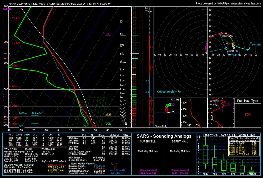
-
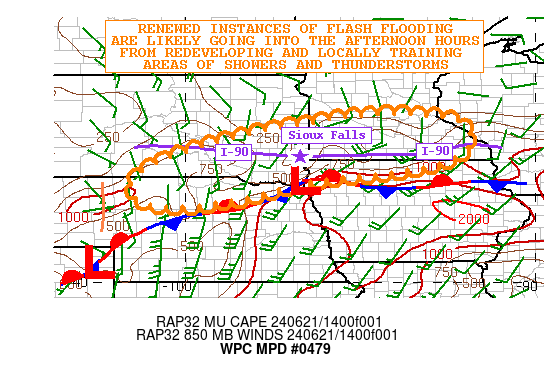
The whole 90 corridor from Chamberlain to Adrian got 3 to 7 inches of rain last night. With another area of 6 plus just S of Sioux Falls. Pretty much every major river from the James to the uppermost Des Moines and pretty much every tributary of the Minnesota is forecasted for moderate to major flooding over the next week. And there's a good chance that some of the same areas could get multiple inches tonight. Even further E, where a corridor from Rochester to Winona is forecasted at 4 to 6 inches in the next 72 hours. Even over here we are forecasted for 2 to 3 inches of rain which is an uh oh amount because we are still so wet locally from the 5/21 to 6/4 stretch.We got 9 inches during that stretch, have had not a lot for 10 days and then just got an inch two days ago with the 2 to 3 forecasted. And tbh, this type of setup has the potential to potentially significantally overperform. This is a very significant flood event underway for the areas to the west, with more to come.
-
As I say that, a FFW now for the West Side of Madison. A training series of popups has dropped like 2" in the last hour, with it still raining. Bad timing with rush hour as well. And today is not that big of a rain setup and we are doing that. Yikes.
-
Well the heavy rain the last couple of days is starting to make it's way into the main stem rivers. The Mississippi at St Paul is now forecasted to get to essentially major stage by the 26th with additional rises thereafter. This is mostly thanks to the Minnesota which is at or forecasted to be at flood stage from New ULM eastward to the Twin Cities. And additional rain is expected, with WPC MDT risks on both tomorrow and Friday, including over the Twin Cities themselves. And the flood threat may extend down here over the weekend, with a chance of storms every day from now until Sunday. And considering we just got a storm that dumped .5"+ of rain in like 20 mins, the atmosphere is certainly primed for heavy rainfall.
-
Some areas just W of the Sawtooths have had 2.5" of rain in the last hour. If those areas drain to the lake, ouch. I would not want to be on some of those streams for the next few hours.
-
Yeah I would not want to be in the eastern BWCAW rn. Areas N of Soudan have 7+" of rain according to KDLH. And there's FFW's all the way to the North Shore now. That is some terrain I would not want to be stuck in a flash flooding event while camping for sure.
-
Yeah the wind has definitely kept things on the not too terrible side. Honestly yeah this heatwave turned to be kind of a nothing burger around here. Warm days and nights, but nothing out of the ordinary, and definitely not what was modeled earlier this weekend. Oh well.
-
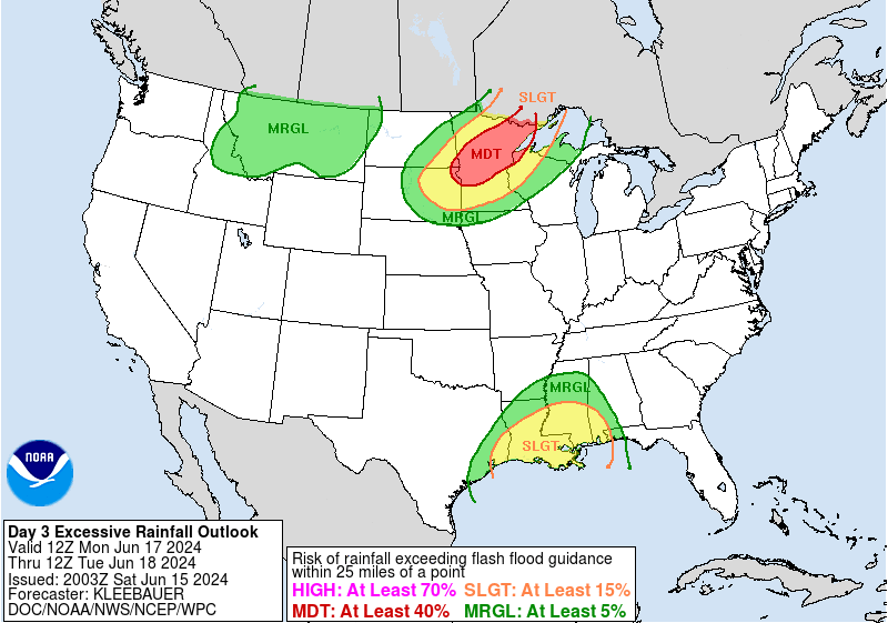
As a corollary to the heatwave, the models have really honed in on a potentially significant flooding event across MN and N WI over the next 7 to 10 days. The WPC has a rare for the region Day 3 MDT for Flash Flooding on Monday, with quite a hefty discussion. They mention the possibility of a flash flooding event not seen in the region in at least the last 10 years within the MDT. Some runs have had as much as 10 inches of rain over the next 10 days in some areas. To make matters even worse, some areas of MN have received as much as 8 to 10 inches in the last month, with several streams at or near flood stage already. Talk about a far cry from the last three summers of flash drought in the region.