Geoboy645
-
Posts
712 -
Joined
-
Last visited
Content Type
Profiles
Blogs
Forums
American Weather
Media Demo
Store
Gallery
Everything posted by Geoboy645
-
It always amazes me how much of a difference there is for # of 90s pretty much every year between Chicago and Madison. Madison is only at 8 for 90s so far this year. Obviously the UHI is a major part of that, but still such a stark difference over only ~85 miles in latitude.
-
Huh, I did not realize the SPC outlook for 8/18/05 looked like that. Crazy it has been 20 years since then. I was too young to remember it personally though. I can't and frankly don't even want to imagine what it will be like when we get another Stoughton or Oakfield level tornado in the Madison area, and we have had a couple close call setups where that would have been possible the last few years.
-
It isn't so much a weakness per se as the edge of a ridge of high pressure. We have been in some variation of a ridge riding pattern for over a month now with only a couple brief exceptions. In this case, the last few days the MS Delta has been absolutely baking underneath a heatwave, and that ridge has flexed in such a way that as of rn its aligned with the I70 corridor. Hence the repeated flooding experienced in those locations the last few days. And overall it has just been a wet month for most areas E of the Rockies as this ridge of high pressure flexes and moves. With the extra moisture from yet another broiling Gulf of Mexico, it has led to a lot of rainfall along the edge of the ridge, and is the reason why it has been so humid even if the temps haven't been so extreme this month here in the Midwest.
-
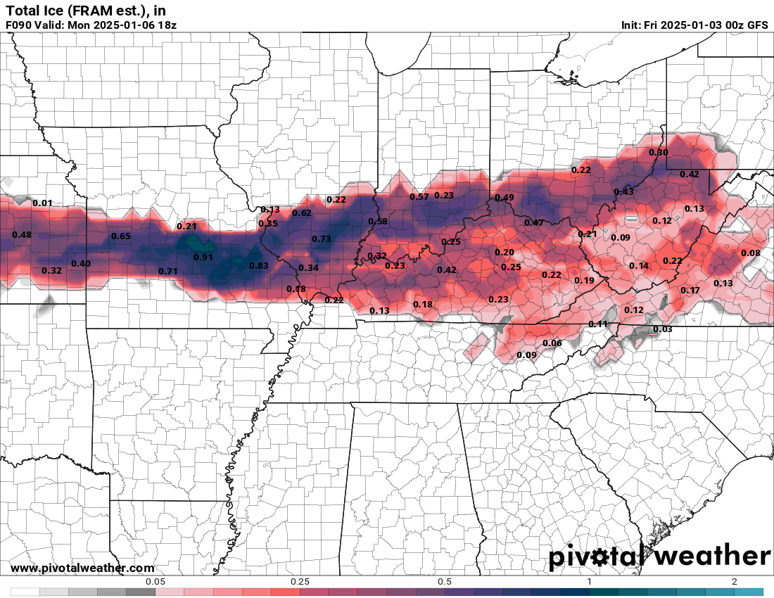
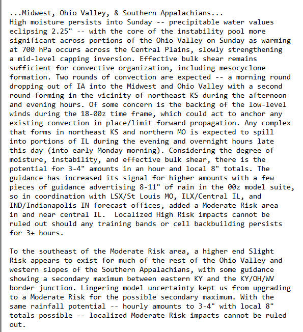
Guess I'll just put this in here, but there's a WPC MDT today for central IL. And the forecast discussion for it is pretty strongly worded. 8-11" of rain is not a small amount of rain to say the least. I don't think there are going to be any drought concerns wherever the precip max sets up after this...

-

Summer 2025 Medium/Long Range Discussion
Geoboy645 replied to Chicago Storm's topic in Lakes/Ohio Valley
Well, looks like after Monday the ridge will move east and then stall, setting up a ring of fire pattern for potentially the rest of the week next week. There are some differences as to where the exact stationary front sets up, however whatever areas that do end up underneath the ring could experience repeated rounds of heavy rain and potential flooding. These setups where there is a large ridge stalled on the E coast and a wide open GOM have caused major flood events in the past, such as a year ago when MN/IA/WI flooded while Detroit and points E experienced several days in the 90s. Definitely something to keep an eye on as we move into next week. -
The forecast has really zeroed in on a potentially quite significant heat wave for most of the subforum starting tomorrow and going through at least the weekend. At least 3-4 days of mid 90s over mid 70s dew points is going to cause heat index values to rise over 100 degrees over the weekend, especially in the Chicago and Detroit UHI's. While at this juncture it doesn't look like record highs are in jeopardy, the heat index and warm nights could cause some issues in the metro areas. This will probably be the most significant heatwave since the 2 day heatwave back in August 23. Figured that this is significant enough to warrant a thread of it's own. Edit: As I was typing this out, ARX just put out an Extreme Heat Watch. With heat indexes up to 105 mentioned over the weekend.
-
Over the last day or so, the Models have really zeroed in on a potentially major severe weather outbreak across the sub forum. Figured that there should be a thread for it considering it's only 4-5 days out.
-
Today felt like a May or June day, not late March. Waking up to morning t-storms that ended about 9. Cleared out and became sunny and warm. And then sunset, with distant anvils and occasional flashes of lightning. All it was missing was the greenery that comes with that time of year. Pretty cool though.
-
Between the ~4" of snow on the ground and the air temps/WCs, it is truly a deep winter day out there right now. After the most recent storm system here, Wisconsin actually has a pretty good snowpack. Most of the state is 4+ with a large percentage 8+. Considering how bad this winter has been for that, that's a pretty big rally.
-
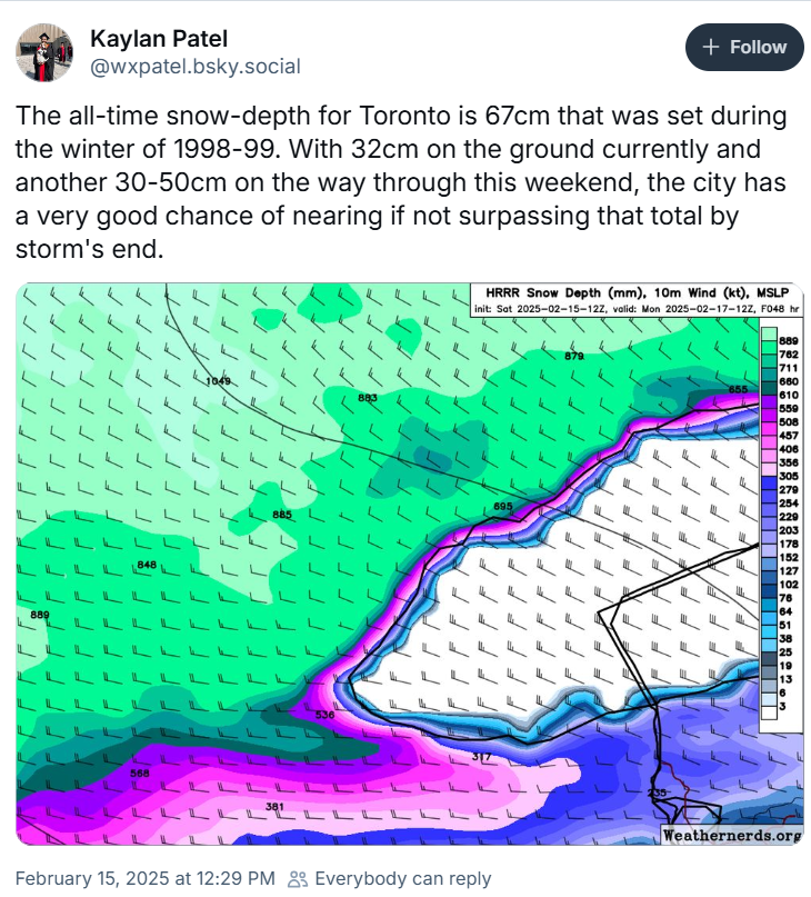
One thing to note for our Toronto people on here. That's potentially 30 inches of snow on the ground.

-
Yeah I am worried about tomorrow sneaking up on people because of the uncertainty. Tonight alone could be an impactful hit because of the timing of max rates during rush hour. But tomorrow is so up in the air this far out which is insane. And if some of the higher solutions verify for us, we'd be talking potentially a foot combined between the two snows on top of the stuff from Wednesday. That's a major storm.
-
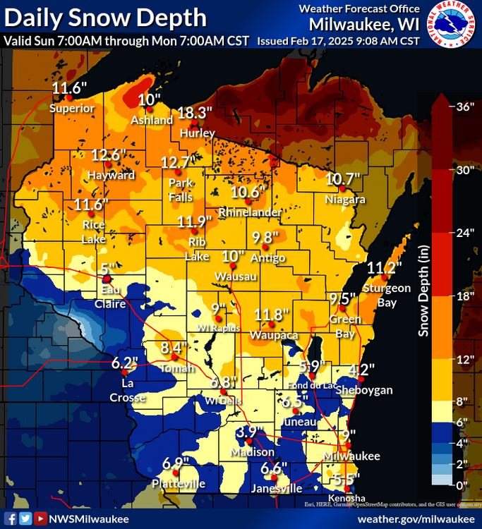
So while yesterday's storm ended up being not that big of a deal in the MSP metro, further E it was actually a pretty significant storm. Wausau recorded 9.5" and reported a snow depth of 12" after yesterday and Green Bay recorded 7" with 8 on the ground as of yesterday. That's a signifcant hit, and does bode well for us down below as it finally sets up a N-S snow depth gradient for storms to track. Edit: This also means that Wausau and Green Bay are at 14.2 and 10.6 inches of snow for the month, respectively. Crazy how just two storms changes things up there.
-
I had something in Wausau today, and traveing back on I-39 from Stevens Point to Portage was a pretty stressful drive with the blowing dust. Had a few plumes cross the road that were so thick it was hazards on and 45mph on the interstate for about a mile before it lightened up again. Would have expected that with snow on February 6th, not dust. Really goes to show just how it dry it has been period, frozen or otherwise, the last couple months.
-
Winter 2024-25 Medium/Long Range Discussion
Geoboy645 replied to michsnowfreak's topic in Lakes/Ohio Valley
One thing to note about the ENSO state this winter is just how late this La Nina is starting. The only other Nina to start in OND was 1949-50. And this Nina has shown significant strengthening over the last couple weeks. That could really throw a wrench into things not only for the rest of the winter, but the whole year in regards to long-range forecasting. -
Yeah like most recent winters, February looks to potentially be the most active month for storms. Definitely a signal after around the 5th of at least some snow chances for the forum. A reminder that we have had winters in the past that look like they were going to be futility winters, and then we have a major rally for snow in February and March. Case in point 22-23 where Madison and Green Bay had ~50 inches of snow accumulate from Feb 14th to April 2nd. We still have quite a bit to go for winter, even if the last week hasn't quite felt like it.
-
Bare ground, sun, and WAA is always a recipe for an overperformance. Going to make the next 5 days feel that much more brutal.
-
Say what you will about this winter, but this incoming cold wave is impressive considering the lack of snowpack both here and upstream. As of rn Monday is forecast to be 0 for a high and both Sunday and Monday nights are supposed to be around -10 for a low. That's pretty significant even if it's not historic or anything. We usually only have one or two 0 or below highs a winter, and pretty much all of those have snow and several inches of snow OTG. So pretty unusual. Of course, if we did have anything resembling a snowpack this would be a major if not historic cold wave. Still will be a frigid few days early next week.
-
Not even the 2021 event? The one that dumped 18" downtown?
-
Do not envy the LSX mets at all rn. If the storm goes even just a bit S, STL gets a foot plus of snow for one of the few times ever in it's record. If it goes just a bit N, STL gets a crippling ice storm of potentially an inch of ice with wind.

-
So are we the Commanders or are we the Bears in this scenario?
-
My top weather events, in chronological order: #1: The 1/6-1/13 snow and subsequent cold period: This one week of snow gave Madison almost 20 inches of snow, including 8.6 on 1/12 and 5.7 on 1/9. Madison had a maximum snow depth of 12 inches, a rare mark for any winter let alone the warmest winter on record. The snow, particularly the 1/12 storm, was incredibly wet and heavy and was an absolute pain to shovel. ANd the pack was so frozen by the cold thereafter that it took a solid 2 weeks to melt with sunny days in the 30s and 40s. If it was a normal winter, that pack would have lasted well into March. The subsequent cold lead to 5 consecutive subzero nights, and one of the deepest winter stretches that I have personally been around for in the last 10 years. Pretty crazy considering it was a strong Nino winter. #2: The 2/8 tornadoes: And less than three weeks later we had one of the most unusual tornado setups in WI history. The day wasn't really all that warm, only in the 50s, and yet somehow there was enough instability to not only get storms, but thanks to some favorable storm interactions a cell dropped multiple tornadoes. Including a 25 mile long sig-tor, in Wisconsin, in February. In a month that previously had no tornadoes recorded ever in the state of WI. And the tornado was a high end 2, and barely missed going through Evansville. Such a strange event to say the least. #3: The warm and dry February and March. February and March were both very warm and dry months relative to the time of year. Madison recorded barely any precip, and had a +10.8 departure for February. And had a +5.1 departure in March. It was genuinely nice out for most of the month, and was capped off by the earliest 70 degree day in Madison's history. Which was then followed by a 73 degree high on 03/03. Easily the nicest weather stretch ever for that time of year, even more than 17 and 12 IMO because of how long it was like that. #4: The 4/2 mix/snowstorm: This one is more Green Bay than Madison, but the 4/2 storm was also an incredibly odd storm. It came up very suddenly, with models only catching on about 48 hrs before the start of precip, and had some pretty major totals forecasted with up to 12 inches of snow forecasted for the city at one point. While these totals did not come to pass, it was an incredibly close call and one of the rare times where terrain played a role in accumulation in Wisconsin. In Green Bay along the river, there was maybe 3-4" of snow. But on top of the Ledge and the Appleton moraine, there was easily 8+" of snow in spots. The warm ground, plus some very low-level marine influence from the Bay led to most of the snow in the Fox valley switching over to sleet. Was a wake-up call after the previously mentioned warm and dry February/March. #5: The 5/21 severe storms: Back home around Madison, we got hit hard locally by the severe storms on 5/21. MKX issued 42 severe warnings and 13 tornado warnings for their CWA for the event. The environment that afternoon was highly conducive for supercells along the warm front, and the only reason we did not have an outbreak along the warm front that afternoon was a deck of stratus to the N of the front that did not move out as quickly as modeled. Forcing the warm front further S and capping it all afternoon with only a couple attempts at initiation. We got very lucky around here considering what happened further W in IA. After the cells from IA congealed into a line, they rapidly advanced into the area. The first round of cells had some significant wind develop with them prompting a PDS severe warning at one point for Dane, Lafayette, and Green counties. This line also had several broad areas of rotation, leading to an absolute mess of tornado warnings. While the main show was happening to the S, we had a downburst move up from the S through my area. This downburst easily had 60-70mph winds, and the winds from the SW meant no terrain protection unlike our usual NW or W winds during squall lines. This led to several trees down in the area, including a particularly bad area right off the lake where going by tree damage, they may have had up to 80-85 mph winds. To add insult to injury, about 30 mins after the winds came through, a second cell developed and came through with at least quarter if not ping-pong sized hail for about 2 mins. Between these two events, the rest of the summer was busy with contractors through the area fixing roofs and siding. Oh, and we also got 4" of rain which ended up becoming a common theme the following two months. This rain was very poorly timed for farmers in the area, as it was just after planting but before emergence. During this period of time, if you get a heavy enough rain you can have something called bedpanning where essentially the soil becomes very hard from the erosion of the heavy rain and it becomes much harder for plants to emerge. There were several fields in the area that ended up not really emerging all that well because of this phenomenon, as well as the river and marsh flooding that resulted from this first round of heavy rain. This is long enough so I will put #6-10 in another post.
-
With the New Year here and final climactic data in for 2024 in, I figured it would be a good time to make the 2024 year in review thread.
-
Winter 2024-25 Medium/Long Range Discussion
Geoboy645 replied to michsnowfreak's topic in Lakes/Ohio Valley
Yeah it's kind of annoying that whenever cold and snow happens, everyone brings up the trio of late 70s winters and then 13-14/14-15 and that's pretty much it. Like we have had so many other cold and snowy stretches in the intervening and subsequent years that are just not talked about. We had several major snowpack and cold winters in the 80s with stretches that tied or beat the late 70s winters such as Dec 83, Jan 85, and Dec 89. The 90s had 92-93, 93-94, and 95-96 which were all all-time winters in parts of the forum. The 94 and 96 cold waves literally set state records that still stand to this day. And recently, 18-19 had one of the most intense second halves of the winter ever with snow and had the coldest period since the mid 90s. And 20-21 literally was the largest cumulative snowdepth (not just one storm like GHD I) since 1979 for large areas of N IL, IA, and S WI. And yes 76-77 was the ultimate tundra winter for the midwest. The infamous Jan had a max snow depth of ...4 inches at Madison. And 8.7 inches of which the max snow was 1.6 for the entire month. Which is incredible for just how cold the temps got that month. -
Well the clipper that passed through today dropped a localized band of 1-3" across the area. Nothing crazy, but combined with the snow from last Thursday, we should have enough of a snowpack to get a White Christmas this year. Unfortunately it's going to all melt later in the week with the incoming 40s, but at least it actually lasted to Christmas and didn't melt right beforehand like previous years.
-
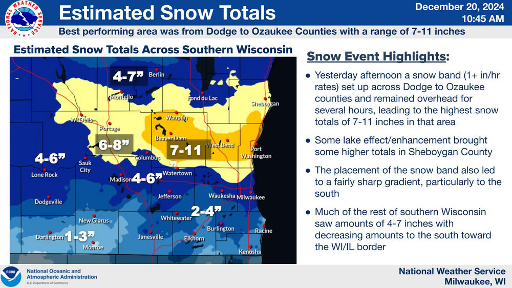
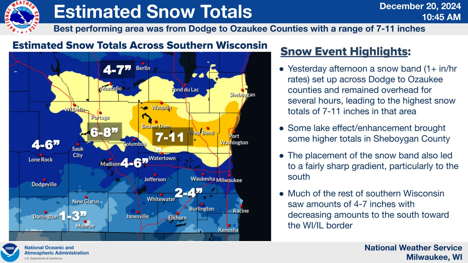
So we ended up well overperforming with the clipper yesterday here. At home Id say we got about 7" here. It actually looks like December outside for once. This is the first time it has looked like this out on Dec 20th in many years. And our first significant clipper since at least 21 if not earlier. Too bad it's supposed to get warm before Christmas, because this would be a perfect snowpack for the holiday. Although we do have enough that we should have at least some OTG for the holiday.