Geoboy645
-
Posts
714 -
Joined
-
Last visited
Content Type
Profiles
Blogs
Forums
American Weather
Media Demo
Store
Gallery
Everything posted by Geoboy645
-

Summer 2024 Medium/Long Range Discussion
Geoboy645 replied to Chicago Storm's topic in Lakes/Ohio Valley
Yeah that's a big problem considering the potential totals. And this would be efficient summer rainfall so it'll be heavy rainfall rates. Idk how well the Twin Cities can handle a lot of rain on top of it tbh. Minneapolis is pretty flat and the lakes aren't really reservoir like lakes. It's a system that hasn't been stress tested with the amount of growth in that metro over the last 30 years iirc Edit: it appears that the last time the metro had a big flash flooding event at least according to the MNDNR site for flooding was 7/19-22 1987. That period set a diurnal record of 9.15 inches at MSP. There's been 37 years of rapid growth since then, especially in important watersheds such as Minnehaha Creek. And that event was pretty localized and not at the same time as the rest of the state being dumped on with already high rivers. -
Summer 2024 Medium/Long Range Discussion
Geoboy645 replied to Chicago Storm's topic in Lakes/Ohio Valley
Uhhh, thats a lot of rain. That would cause some serious issues on the Minnesota, Upper Mississippi, St Croix, Chippewa, Black, and Wisconsin rivers. Almost 9 inches of rain in the Twin Cities in 10 days would be a really big deal. They have missed a lot of the big summer flooding events within the last 15 years, that's looking like that will change here. -
Well it is looking more and more likely that next week will bring a significant heatwave to the subforum, especially to the S and E parts of the forum. Models have been consistent for a few days on at least 4 or 5 days of mid to upper 90s highs and mid 70s lows starting on Sunday and continuing at least until Friday. Detroit already has a point forecast of 97 on the 19th and 20th which is pretty notable for 5 days out. There's a pretty decent chance that some areas away from the lake in OH and IN tag 100 for the first time since 2012 imo. This ridge is portrayed on some models as going over 600dm which is significant for the region as a whole, let alone being centered over ...Erie PA. Further NW this will probably be more of a typical warm wave with maybe warmer than usual nights. Here in Madison area we are going to be right on the edge of it, as per usual, and it's going to really depend on exactly where it sets up each day if we get the main heat or not. All in all, a potentially significant amount of heat is in store for next week across the Midwest.
-
I think the big thing with this upcoming heat wave isn't so much pure temps, but the dews and the overnight lows. As of rn, the point here has around 90 and 70 degree plus lows every day after Sunday. Downtown Chicagos point is at like 92-95 with mid 70s lows for multiple days in a row. While not super rare, 3 or 4 nights in a row with those lows is still a big deal, especially for people without AC. And the extended looks like more of the same at least S of 80.
-
We ended up getting trained by storms from about 7 to 10:30 last night up here. The closest wunderground station with reliable precipitation data has 2.14" of rain for yesterday. We are now at around 9" of rain since May 21st. The killer is is that even the smaller rain events have overperformed.
-
Y'know what would be nice, if it stopped raining here for a couple days. We have had 6+" of rain since last Monday, with more tomorrow. And its been like an inch or more of rain everytime it rains. Even yesterday's more moderate rain still had a heavy cell that pushed us over an inch here and dumped 2+ between Fall River and Beaver Dam. A brief break on Wednesday/Thursday before even more rain chances over the weekend. All of the rivers are at bankfull, the marshes are getting flooded, and most fields have at least a bit of standing water in them. Easily the most water we have had since 2019. If we get a major rain event (like 4"+ or even 2" if it falls very quickly) we are going to have some major problems across the area. It doesn't even need to be an 07/08/18 style marathon. Even a May 04 event would be very bad rn with how saturated we are.
-
Yeah can we not do a repeat of that? It's going to take at least another week to get fully cleaned up here from Tuesday, and with the Crawfish still quite high we are prone rn to any major rainfall. That's honestly my biggest concern atm out of this stretch, as essentially the corridor from Lodi to Doylestown to Fox Lake to Waupun can't take a whole lot more rain after Monday/Tuesday. As well as points west along the Baraboo, although they are still coming off the drought there so its not as bad. If we get unlucky with either total rain amounts or rainfall rates we could be talking some potential issues along the drainages along that corridor come Monday. We have the potential for the biggest flooding event in the area since the Wild Card flooding in October 2019 in my opinion.
-
Well last night's QLCS was a long night here. We got the initial tor-warned round through at about 8, that line didn't do too much damage. However, we got the straight-line winds from the SW from the 2nd round, and that did some damage around here. There are probably a few dozen fallen or snapped trees around the area from the wind, with some areas losing power as a result. If I had to guess we probably got 70+ winds, if not 80+ in the most exposed areas. Notably with the wind coming out of the SW, areas that would be relatively protected from our typical NWerly squall lines experienced the full brunt. Coupled with weakening from last years drought and EAB, no wonder we lost so many trees. Easily the most wind damage we have had here in almost a decade. The last time being the downburst on 7/13/15. After that round came through, some redevelopment occured and we had about 4-5 mins of quarter-sized hail. And while all of this was going on, we got at least 2" of rain. Combined with the rain from the MCV on Monday, some areas to the north of me have had 4-5" within the last two days. The Crawfish is up to bankfull now for the first time in at least a year if not longer. Been a very busy last two days here.
-
Meanwhile up here in GRB, we actually have had a bit of a precip streak going since Friday. Every day since then has had at least .01 inches of rain. And the forecast for the next week shows a pretty good chance of that streak going all the way to potentially next Sunday if later. If we get to 8 days, so Saturday, it's a top 10 all time streak for days above .01 inches of rain. And 11 is our record, from April 1973. GRB has also mentioned areal flooding concerns as we get into the later part of the week, as even though this hasn't been heavy rain with the highest being .32 on Saturday, the streak of days starts to add up after a while. Especially if we get into some heavier stuff on Thursday.
-
Pretty impressive flip-flop between yesterday, today and tomorrow. Yesterday, 78 and sunny to partly cloudy all day with showers and storms later in the night. Today, midday highs barely breaking 45 and rain pretty constantly all day. And then tomorrow it's supposed to warm back up to 68 and partly cloudy. In fact, the lowest temps of the period were at like 1 today when it was 43 out. Temps have been slowly rising since then and should continue all night long.
-
SPC has introduced a Day 4 15% across IA/IL/WI all the way to the UP Border.
-
The models within the last couple of days have really honed in on a potential multi-day severe and heavy rain threat over this weekend over the western part of the forum. With a particular focus at this point on Friday in IA for severe and a heavy rain event over the Upper Mississippi Valley for the weekend. Considering how wet it has been in that part of the forum for the last month and a half, there may be some flooding concerns as we get closer. Could be a very busy weekend here in the Midwest.
-
Yeah up here at least our forecast doesn't drop close to 32 all week. Coupled with all the recent precip and sunny days later in the week, everything should be going nuts for green up by the end of the week.
-
4/2-4/3 Significant Late-Season Snowstorm (WI/MI)
Geoboy645 replied to Geoboy645's topic in Lakes/Ohio Valley
We maxed out at about 5 inches on the ground around midnight on Wednesday. We switched to mix after that and we only had about 2 inches after that. One thing about this though is how wet it is here now. We went from basically no puddles when it rained two weeks ago to now puddles everywhere on the lawns and sidewalks. GRB has had 1.36 inches in the last three days and 2.76 inches in the last three weeks. Talk about a turnaround here -
4/2-4/3 Significant Late-Season Snowstorm (WI/MI)
Geoboy645 replied to Geoboy645's topic in Lakes/Ohio Valley
It's been pretty gnarly so far here in GRB. We had thundersnow about 2 hours ago that I unfortunately did not hear. The wind has really picked up and we have I would say 3-4" on the ground. I think we have transitioned back to mix here as well though, although it is hard to tell. If we have transitioned back to mix, that could cut down on our totals however. Either way it is a slushy mess outside rn. -
4/2-4/3 Significant Late-Season Snowstorm (WI/MI)
Geoboy645 replied to Geoboy645's topic in Lakes/Ohio Valley
We fully switched over to snow about 2 hours ago. It has been heavily coming down since, with probably 1-1.5 inches or so accumulation so far on grass. Green Bay officially has us at 8-12" for snowfall, with 12-18 further N. What an escalation considering 48 hours ago we were talking snow showers. It's going to be a long night here in Green Bay. -
4/2-4/3 Significant Late-Season Snowstorm (WI/MI)
Geoboy645 replied to Geoboy645's topic in Lakes/Ohio Valley
-
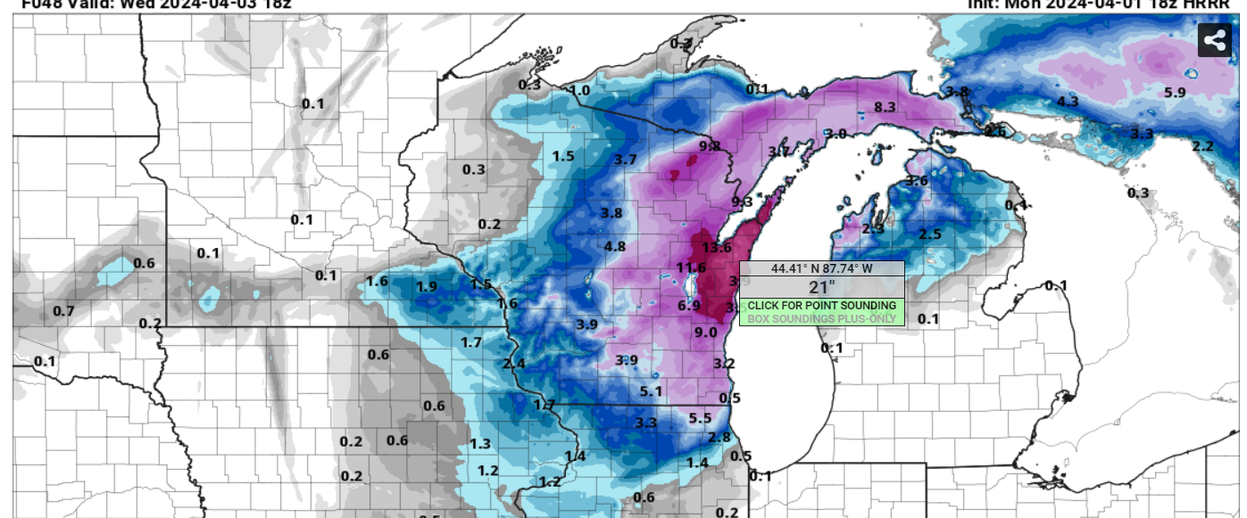
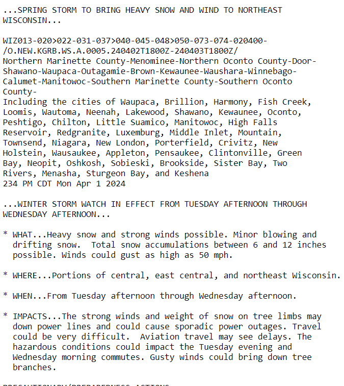
I figured this needed it's own thread at this point. So the models over the last 24 hours have really come into agreement that tomorrow into Wednesday across Wisconsin and the UP. Some models like the 18z have over 20 inches (!) of snow on the Ledge by this time Wednesday afternoon, and it's still snowing. Which is absolutely insane. There's also the potential for up to 50mph gusts during this event as well. And with the lake being completely open and warm for this time of year, there is a decent chance of lake enhancement off of Green Bay. If that happens, then the sky is the limit for potential in the Fox Valley with this storm in my opinion.

-
It's already starting to snow a little bit here in Green Bay. GRB has issued a winter storm watch for tomorrow and Wednesday for it's eastern half and this is pretty strong wording considering the low lead time for this. This is really giving me the same vibes as 3/25 last year. Large area of snow, with a death band that we don't really know where it's going to set up in the event is underway. And this time, there's going to be a hefty wind component to it. Green Bay may legit get it's second foot plus storm this year which is insane considering the rest of the winter.
-
....wait what...
-
Spring/Summer '24 Banter and Complaint Thread
Geoboy645 replied to IWXwx's topic in Lakes/Ohio Valley
I'd say this winter was a C- here. The theme of this winter was what it wasn't doing for really all but two weeks. Basically no snowcover, consistent temps in the 30s and 40s, and two double digit positive monthly anomalies. A green Christmas with 50s and rain, and oh yeah a sigtor on February 8th (!). However, the two weeks that were wintry were one of the more intense winter periods we have had in the last 5 years. Probably number 3 after the last week of Jan in 2019 and the two weeks in Feb 2021. Over 20 inches of snow followed by a week in the single digits is pretty intense no matter what the winter is. And that snowpack was extremely solid. Even with the constant 40s after the period, it still took over two weeks for the snowpack to melt. If it was a normal winter we might just now be finishing off that snowpack. So I can't really go too low with the score because of that. Hence, my score of a C-. -
You could say that yeah. So much for those futility records lol.
-
Yeah the consistent signal for the beginning of a stormy period has been nice to see the last few days. What's not been so nice is the signal that at least some of that precip could be of the frozen variety especially in the N of the forum. But precip is precip, and basically everywhere can really use some right now no matter the type.
-
According to Xmacis, looks like April 6th, 1912 is the latest Minneapolis crossed the 1" mark for the year. Interestingly enough, that was also a Nino albeit it only got 1.4 instead of 1.8 departure. The difference however is that 1911-1912, especially January 1912, was one of the coldest winters ever for the Midwest. Like Minneapolis averaged a *checks notes* -18.9 departure for the month in January (!). Quite the opposite of this winter to say the least.
-
Yeah if we don't have a wet March then we are going to be in big trouble across most of the Upper Midwest. We really didn't recover from the drought all that much even in the wetter areas last fall. Combine that with the no frost and snowpack and we are already about 2-3 weeks ahead arguably from an evapotranspirational standpoint. I have some serious concerns especially for MN and the Northwoods where they didn't even get the snow in January.