CAPE
-
Posts
34,143 -
Joined
-
Last visited
About CAPE

- Currently Viewing Topic: July Discobs 2025
Recent Profile Visitors
41,754 profile views


-
"We" lol Literally no one likes you here. You contribute nothing of value. And you were whining. OMG it's not raining in my yard...........................!!!!!!!!!!!!!!!!!!!!!!!!!!!!!!!!!!!!! You have little understanding of the complex nature of the atmosphere, which is fine. Read more, post less. And don't make stupid, snarky replies to a met, moaning when it isn't raining on your little yard when you think it should be.
-
If you want to make a whiny ass post, have at it. But don't do it as a snarky reply to a well respected, well liked Met in our sub forum. Who the hell are you to question his assessment of the situation?
-
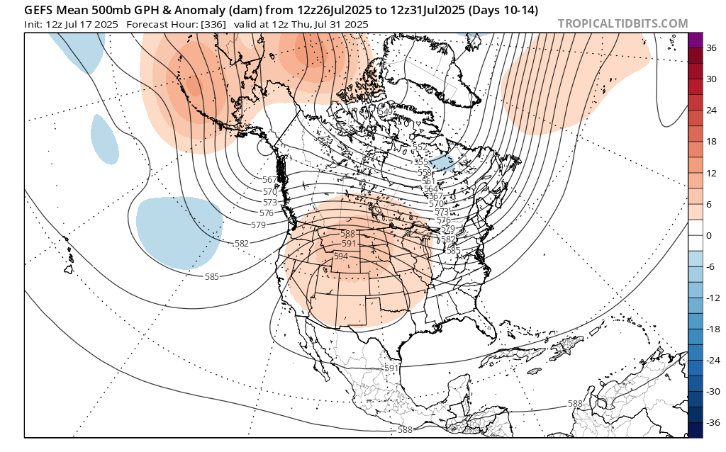
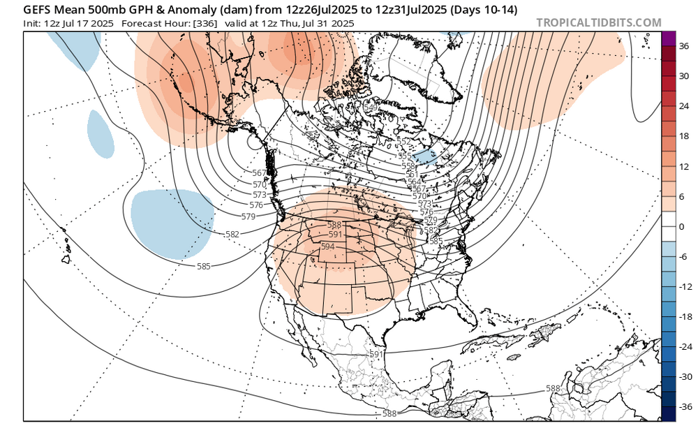
Upper ridge builds out west for the last week of July and looks to persist into early August. We will still see some hot weather ofc, but not the oppressively high dewpoints.
-
GEFS concurs (as does the EPS). Canadian HP. Yeah baby! I took Monday off. Gonna explore Conquest Preserve NW of Centreville. Never been.


-
5.1" for the month after last night. More than double the June total. Needed July to deliver and so far so good.
-
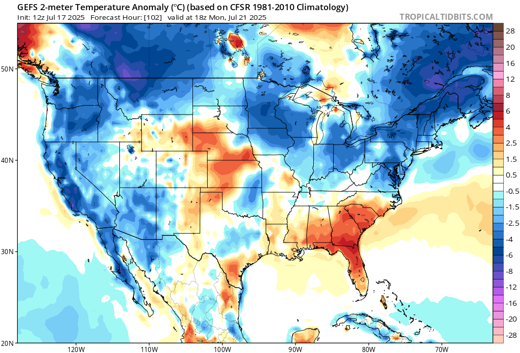
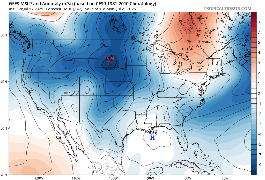
Guidance suggests early to mid next week(maybe beyond) will be very nice for mid-late July. After the front moves through over the weekend, Canadian HP builds southeastward into a position over NE. Low to mid 80s with reasonable dewpoints will feel like early Fall compared to what we have been dealing with lately.
-
 CAPE changed their profile photo
 -
Ok that was a pretty impressive storm and better than I expected. Nothing severe but entertaining with a decent amount of rain. 0.76" with some lighter rain continuing.
-
Impressive T&L right now. Pouring rain.
-
Not much here so far- .03". Hearing some persistent thunder with weakening storms on the doorstep per radar. Hopefully it holds together. A half inch would be nice.
-
What brand do you use? I buy Sawyer on Amazon. Good Stuff but crappy pump spray dispenser. Super annoying.
-
I'll take a walk on the treadmill in the AC. Right after I finish this 90 min IPA.
-
After getting chiggers on my ankles and multiple seed ticks in a place no man wants them, I always immediately shower or at least take a damp towel and brush down my legs and feet. Worse than normal this Summer. This morning I put knee boots on to pull some weeds lol. Skeeters aren't bad but the Asian Tigers usually show up for the last third of Summer and into early Fall(second summer).
-
All that digging and playing in the dirt you do, have you managed to avoid chiggers? I do a lot of the same stuff here(to a lesser degree now) and every time I have been lazy and not sprayed myself, I have paid for it lol. I try to do my 'playing in the dirt projects' in early Spring and later in the Fall for the most part.
-
Seems like they let all the good people go so they can afford the contract with Pat McAffee. He is in on everything. Talk about overexposed.
-
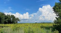
Yeah when I drove by yesterday and saw the clouds and the way the sun was highlighting everything I was like I have to turn around and get that shot lol.