PhiEaglesfan712
-
Posts
1,740 -
Joined
-
Last visited
About PhiEaglesfan712

-
2026-2027 Record-breaking El Nino
PhiEaglesfan712 replied to Stormchaserchuck1's topic in Weather Forecasting and Discussion
Some years are missing, like 1995 and 2007. December 1994 and 2006 were very warm (actually the November-January period was near record warm), while February 1995 and 2007 were the outlier cold months. -
2026-2027 Record-breaking El Nino
PhiEaglesfan712 replied to Stormchaserchuck1's topic in Weather Forecasting and Discussion
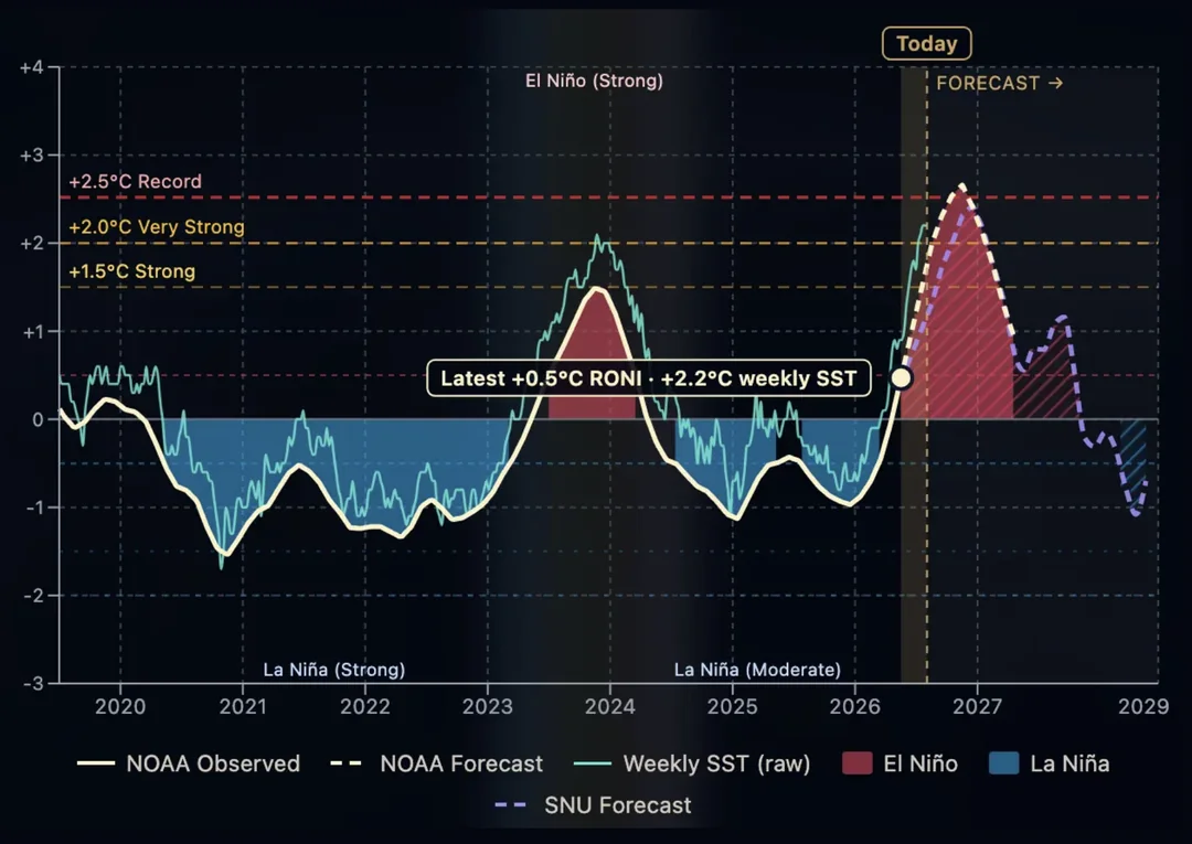
This is how the carry-over el nino scenario would look like. This is actually an AI model that (correctly) predicted this very strong el nino. This shows a carry-over (moderate) el nino in 2027-28, before transitioning to a la nina in 2028-29.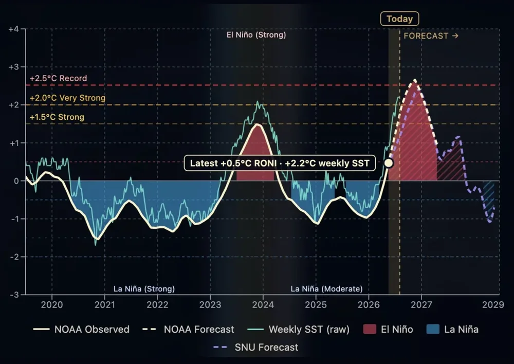
-
I wonder if August is going to complete the trifecta of positive temperature departures during the first half of the month and negative temperature departures during the second half of the month for this summer, or if August will end up being the most consistently warm month.
-
Using 1850 as a start point minimizes the damage. The global temperature trend goes downward until about 1917. If we used that as a start point, then the rise would be closer to +2C in ~110 years.
-
2026-2027 Record-breaking El Nino
PhiEaglesfan712 replied to Stormchaserchuck1's topic in Weather Forecasting and Discussion
Yeah, 2009-10 and 2010-11 proved that. Those winters had a lot of snow in a very short period of time. Imagine how high they would have gone if they didn't come to an abrupt end. -
2026-2027 Record-breaking El Nino
PhiEaglesfan712 replied to Stormchaserchuck1's topic in Weather Forecasting and Discussion
Yeah, it's time to start paying attention. When there is a cold signal this strong during a robust el nino, it's trying to tell you something. Just look at 2009-10, which had a very strong cold signal there in the fall (of 2009). That one came with a backlash la nina. The 2009-10 strong el nino formed and dissipated quickly, which allowed a transition to a strong la nina. I wonder if the upcoming el nino peaks early and gives way to the development of a strong la nina in 2027-28. If it does, then expect a record warm summer in the East. Backlash la nina years, like 1973, 1988, and 2010, have produced record warm summers at PHL. -
2026-2027 Record-breaking El Nino
PhiEaglesfan712 replied to Stormchaserchuck1's topic in Weather Forecasting and Discussion
I'm not on any train. I actually think this upcoming winter will be snowier and colder than most people think. I bet it isn't warmer than 94-95 in the Eastern US. -
2026-2027 Record-breaking El Nino
PhiEaglesfan712 replied to Stormchaserchuck1's topic in Weather Forecasting and Discussion
You know, I really don't give a rats arse about the months that produced a +10 in the West, like Dec 2024, or Dec 2025-Feb 2026, especially when it was cold in my area. Plus, there were more months than March 2012 and January 2006 that had +10 departures. I bet I could find months before January 2006 that had +10 departures. In the East, we had January 1890, 1932-33 (the Dust Bowl years, I'm sure you've heard of that), and 1950. -
If 7/15/1995 isn't on this list, I refuse to believe it's true. That was a very anomolous event. That is by far the highest dew point/heat index in most of the surrounding area.
-
At least consistent 80+. We won't hit the high temperatures of May-July, but we're not going to be in the 70s (or even lower) in a matter of a few days after the heat is over.
-
Now imagine how bad that drought would have been if Floyd didn't happen. 1998-2002 would have been a historic drought.
-
2026-2027 Record-breaking El Nino
PhiEaglesfan712 replied to Stormchaserchuck1's topic in Weather Forecasting and Discussion
To be fair, our last volcanic winter (post-Pinatubo) wasn't that severe. The period between 1991-96 was near normal temperaturewise, maybe a bit below normal. Once the 1997-98 el nino happened, things turned warmer permanently. -
2026-2027 Record-breaking El Nino
PhiEaglesfan712 replied to Stormchaserchuck1's topic in Weather Forecasting and Discussion
All you have to do is look at the previous robust el ninos. There are only really 2 scenarios that make sense here: 1. carry over el nino, like 1987 2. backlash la nina, like 1972 and 1998. If the el nino wasn't going to be outlier strength, I would say 2 was a forgone conclusion. But the el nino might be so strong, the carry over solution cannot be ruled out. I don't know which scenario is going to happen, but it should become obvious by late spring/early summer. For example, by May/June 2010, anyone could see it was pretty clear that a strong la nina was forming. -
I have always believed that if not for Hurricane Floyd, we would have likely had a near 5-year continuous drought. The 2002 drought, of course, ended with the severe snowy winter of 2002-03.
-
2026-2027 Record-breaking El Nino
PhiEaglesfan712 replied to Stormchaserchuck1's topic in Weather Forecasting and Discussion
I wouldn't be surprised if we had a carry over el nino, like 87-88, in 27-28. But it's going to end early, and we're going to get a head start to a strong la nina like in 88-89, in 28-29. It will probably be a one-year la nina, but a very strong one. We'll get the 3rd el nino in the early 2030's, like 91-92 (but probably not with a major volcano).