

Hurricane Agnes
-
Posts
9,355 -
Joined
About Hurricane Agnes

- Birthday 01/09/1962
Recent Profile Visitors


-
E PA/NJ/DE Summer 2026 Obs/Discussion
Hurricane Agnes replied to PhiEaglesfan712's topic in Philadelphia Region
I finished up with 0.39" yesterday after a couple rounds (2-day total 1.29"). Currently a misty 68 with dp 68. -
E PA/NJ/DE Summer 2026 Obs/Discussion
Hurricane Agnes replied to PhiEaglesfan712's topic in Philadelphia Region
Just listening to NOAA Weather radio and heard the auto-guy call your area "Qwee-care-town. So far the rain band has diffused over me and I only have 0.10" in the bucket after a couple passes, with only light rain sitting over me at the moment. Not complaining since I got 0.90" yesterday . Currently 70 with dp 69 (had a high of 83 today).. -
E PA/NJ/DE Summer 2026 Obs/Discussion
Hurricane Agnes replied to PhiEaglesfan712's topic in Philadelphia Region
Tornado Watch lofted - -
E PA/NJ/DE Summer 2026 Obs/Discussion
Hurricane Agnes replied to PhiEaglesfan712's topic in Philadelphia Region
Severe Thunderstorm Watches issued for the area - -
E PA/NJ/DE Summer 2026 Obs/Discussion
Hurricane Agnes replied to PhiEaglesfan712's topic in Philadelphia Region
Love the rainbow at the end of the video! -
E PA/NJ/DE Summer 2026 Obs/Discussion
Hurricane Agnes replied to PhiEaglesfan712's topic in Philadelphia Region
Have been watching the cell just SW of Allentown. it seems to be reforming. -
E PA/NJ/DE Summer 2026 Obs/Discussion
Hurricane Agnes replied to PhiEaglesfan712's topic in Philadelphia Region
Sun back out. Finished up with 0.90" of needed rain. Currently 71 with dp 71. -
E PA/NJ/DE Summer 2026 Obs/Discussion
Hurricane Agnes replied to PhiEaglesfan712's topic in Philadelphia Region
Under angry blob with >2"/hr. Have 0.57" in the bucket. Temp 68, dp 66.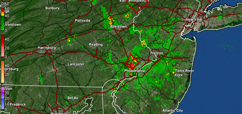
-
E PA/NJ/DE Summer 2026 Obs/Discussion
Hurricane Agnes replied to PhiEaglesfan712's topic in Philadelphia Region
Have hear 2 loud thunderbooms from the cells that are moving east of me. There is some mPing report of >1" hail. The dews crept into the low 70s but with the convection to my east, they dropped a few degrees. Hit up to 89 after a 67 low snd before the popcorn started. Currently 81 with dp 68. -
E PA/NJ/DE Summer 2026 Obs/Discussion
Hurricane Agnes replied to PhiEaglesfan712's topic in Philadelphia Region
It's official. Chief meteorologist Cecily Tynan to retire after more than 30 years with Action News Her last broadcast will be on Monday, Aug. 31. https://6abc.com/post/cecily-tynan-retirement-announcement-6abc-action-news-wpvi/19562769/ Birds will be in mourning ! -
E PA/NJ/DE Summer 2026 Obs/Discussion
Hurricane Agnes replied to PhiEaglesfan712's topic in Philadelphia Region
EF0 confirmed at Cape May Point plus info on 3 other tornadoes that day - As an OBS, I bottomed out at 63 this morning and it's currently a sunny 75 with dp a refreshing 58. -
E PA/NJ/DE Summer 2026 Obs/Discussion
Hurricane Agnes replied to PhiEaglesfan712's topic in Philadelphia Region
Well I finished up with a whopping 0.09" while watching the training sefere slobg the PA/ND/DE border. high was 86/low 71. KYW was talking about the waterspouts becoming landspouts down at Cape May Point. Area will be surveyed today. Currently overcast and 71 with dp 70. -
E PA/NJ/DE Summer 2026 Obs/Discussion
Hurricane Agnes replied to PhiEaglesfan712's topic in Philadelphia Region
Tornado Watches up for the area (plus a TOR in north Jersey) - -
E PA/NJ/DE Summer 2026 Obs/Discussion
Hurricane Agnes replied to PhiEaglesfan712's topic in Philadelphia Region
Amazingly, I dropped even lower for a low this morning after posting, that hit 59. That meant AC off and house aired out. Did get up to 85 for a high and it's currently 77 with dp 62 - more normal for summer. -
E PA/NJ/DE Summer 2026 Obs/Discussion
Hurricane Agnes replied to PhiEaglesfan712's topic in Philadelphia Region
I was wondering what happened when my GR2Analyst stopped updating yesterday. I eventually switched to KDOX. I ended up at 87 for a high after a 69 low and only picked up 0.34" total from 2 rounds yesterday . Today was like day and night with the dp drop... actually tolerable. High was 82 after a 69 low and smoke mostly cleared out. Currently mostly sunny and 80 with dp 60.


