All Activity
- Past hour
-
My front lawn is on a small hill facing north under a tree. Trees line the curb on the other side of the sidewalk. I would love turf to keep the leaves from settling in between blades and creating bare spots. In addition to the moss that takes over because of the north facing lawn with low sunlight. I thought about putting fake grass down. lol
-
I dunno man, the thermometer at Westside pool in Staunton's west end had frequent 100+ readings back in the 1990s!
-
12z GFS not backing off the heat for Thursday and Friday. 104 in Central Park for Thursday, with some 106 readings near Newark, and 105 in Central Park on Friday, with some 106 readings in northern Manhattan/Hudson County. At least humidity will be minimal.
-
(002).thumb.png.6e3d9d46bca5fe41aab7a74871dd8af8.png)
Central PA Summer 2026 Discussion/Obs Thread
ChescoWx replied to Voyager's topic in Upstate New York/Pennsylvania
With a chance that some locations could see a 100-degree day later this week I went back and analyzed 30 temperature stations across the area to see just how rare such a day has become. A 100-degree day is a rare occurrence across most spots across the County. With the potential being even more rare across the relatively higher ridge stations above 595 ft. In fact the last time any ridge location station saw a 100-degree reading was 15 years ago back on July 22, 2011. Of the 18 current stations across the area that report temperatures 9 of these have never recorded such a day. Our lowest elevation stations at Phoenixville and nearby Spring City both recorded a 100+ day last June. To illustrate how different the temperature elevation impact can be on June 26, 2025 while Spring City (256 ft ASL) was hitting the century mark....not too far away at Glenmoore DEOS (620 FT ASL) but 400 feet higher the high was 10 degrees cooler at "only" 90.6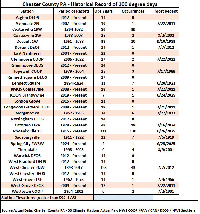
-
E PA/NJ/DE Summer 2026 Obs/Discussion
ChescoWx replied to PhiEaglesfan712's topic in Philadelphia Region
With a chance that some locations could see a 100-degree day later this week I went back and analyzed 30 temperature stations across the area to see just how rare such a day has become. A 100-degree day is a rare occurrence across most spots across the County. With the potential being even more rare across the relatively higher ridge stations above 595 ft. In fact the last time any ridge location station saw a 100-degree reading was 15 years ago back on July 22, 2011. Of the 18 current stations across the area that report temperatures 9 of these have never recorded such a day. Our lowest elevation stations at Phoenixville and nearby Spring City both recorded a 100+ day last June. To illustrate how different the temperature elevation impact can be on June 26, 2025 while Spring City (256 ft ASL) was hitting the century mark....not too far away at Glenmoore DEOS (620 FT ASL) but 400 feet higher the high was 10 degrees cooler at "only" 90.6
-
he said noisy, not nosey
-
ridge roller season getting into full swing this week, looking forward to the axis sinking south as we head into july latest euro selling a classic look
-
Up to 87 quickly today
-

2026 Mid-Atlantic Severe Storm General Discussion
Pityflakes replied to Kmlwx's topic in Mid Atlantic
Pattern change heralding derecho around 7/10? GFS has had the idea for a few runs now -
Yea he hates the Knicks.
-
Short term forecast was mainly cloudy this aft, I know not what the pops % were but it was pretty low. Gets dark at noon, find light to mod rain coming fast outta nowhere. This is the 2nd worst short term peg this year. The aft is cooked. My 7 day is changing wildly run to run so any precip is a pure guess.
-
You mean die, not suffer.
-
So if we hit it twice, does this mean you will watch it 4 times?
-

2026-2027 Super El Nino
snowman19 replied to Stormchaserchuck1's topic in Weather Forecasting and Discussion
One thing I’m very, very confident in as far as winter, is a much warmer than normal to “torch” December this year because of what myself, @GaWx and you already discussed….the very strong correlation over the last 46 years (since 1980) of +QBO/El Nino (regardless of strength) Decembers being a slam dunk signal for warmth…literally 6 out of the last 6 were warm…. -
-
DPs over IL/IN/MI 75 to 80 55-60 locally. That air mass out there is heading this way. I don't know how exactly the that air mass entangles with the Lakes and then tumbles over terrain for us... but I could see there being some convection on the leading rim of that as it nears.
-
Apparently the ole temp sensor in the backyard station needs some work. It’s warm, but 90/81/108 at 10:55am seems a touch extreme
-

Occasional Thoughts on Climate Change
donsutherland1 replied to donsutherland1's topic in Climate Change
The latest estimates I have seen is 2.19C-2.26C (3.9F-4.1F): European land temperatures have increased even faster over the same period by 2.19 to 2.26°C, depending on the dataset used. https://www.eea.europa.eu/en/analysis/indicators/global-and-european-temperatures -
-
Lakeshore Keepers is a non-profit organization that maintains five lighthouses along the West Michigan shoreline. We have recently installed live-feed cameras either in the lantern rooms or just outside to be able to give better access to our lights. These cameras can be found here! Lighthouses include: White River Light Station (Muskegon County), Little Sable Point (Oceana County), Ludington North Breakwater (Mason County), Big Sable Point (Mason County), and Manistee North Pier (Manistee County)
-
I don't know if I would necessarily bet against it, however, I would put forth some caution into the extent of what some of the forecasts are in terms of its strength. I think its just way too premature to start tooting around x,y,z are happening because we have a super-strong that is developing. I still don't necessarily see how a lot of comparisons can be drawn to how the atmosphere is responding to something developing, particularly when it comes to the ocean. There is quite a time lag between ocean-atmosphere response. It's not like the atmosphere is going full EL Nino mode because the ocean is warming...there will be some time before that warming in the Pacific has a full-fledged impact on the atmosphere. For example, most EL Nino's, particularly stronger ones will tend to peak during the Fall at some point and begin to weaken moving through winter, but its not until the winter months in which you see a much stronger correlation to the impacts of EL Nino.
-
Update: 22 inches as of 9:00 local time today at Darkhorse Lake. I bet if this was July it could be a state record for the month.
-
Usually the Tuesday before Labor Day. So last yr 8/26. We also don't do the week off in Feb.
-
Correct
-
Absolutely, Don. It still would have been another historic heatwave even without AGW but not near as historic as it got due to the added effects from AGW. A larger portion of this extreme heat was very likely due to the pattern, itself, as opposed to AGW, itself. But AGW means a higher baseline as your quote said. The global baseline average has warmed ~2.5F since the late 1800s and not far from that even since just the mid-20th century if I’m not mistaken with the Arctic significantly higher and the tropics lower. How much do you figure the W Europe climate baseline has warmed?