
UnionCountyNCWX
-
Posts
266 -
Joined
-
Last visited
1 Follower

About UnionCountyNCWX

- Birthday 11/02/1994
-
yea I read your post on this thread and then it crashed lol
-
Let it be known that literally no one called for this..... but we will for sure take it. What a beautiful surprise this morning.
-
Moderate rain in south CLT. most we've gotten in weeks
-
We got DRIZZLE in CLT! DRIZZLE I tell ya, almost got my car wet.
-
Ladies and gentleman, the broiler is about to be turned on.
-
What im hearing is the LP is shown to be actually strengthening as its coming up through Georgia which is why model outputs look a little different this morning. I want to say "for the better" but also showing increased wind and heavy rain may be an issue for limbs and power lines.
-
RDU officially recorded 101.
-
Latest GFS doesn't show a whole lot of promise. the only "meaningful" rain fall set up looks to be next Tuesday and Wednesday. Sure the overall isolated/scattered afternoon storms seems like a good bet just about everyday. but only one real chance of an area wide rain through basically the end of the month.
-
Saw several posts today calling for a super El Nino this summer. Which...haven't most of them been strong (or beyond strong) over the past few years, the ones we've had????
-
It amazes me how many times this map has been repeated this spring.
-
We got absolutely smashed in union county this morning. Was not expecting that. (Was only in town from Charlotte to mow grass, that obviously didnt happen)
-
I left for a cruise on the 17th, just got back this morning. The no rain anywhere to heavy rain/ flooding/ tropical news for a large portion of the SE happened fast.
-
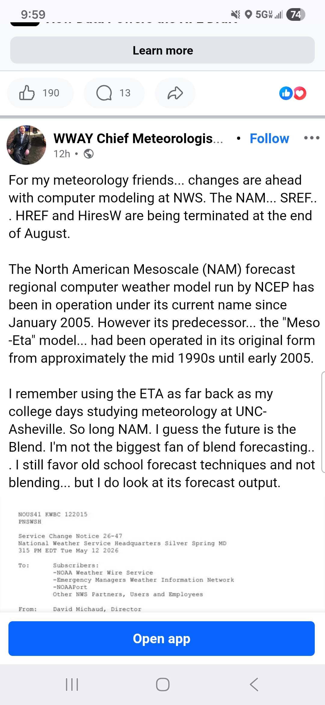
I take everything with a grain of salt, but I think I heard someone mention it in here in the past as well....im gonna miss being NAM'd.... in both good ways and bad lol
-
Got a gut feeling we won't see the sun in July. At some point it has to reverse course right?
-
"We needed this" - Everyone. Good to see a forecasted rain event come to fruition.