All Activity
- Past hour
-

Occasional Thoughts on Climate Change
TheClimateChanger replied to donsutherland1's topic in Climate Change
Yes—strong El Niños do cause short-term spikes in global temperature. But ENSO is an internal oscillation—it redistributes heat, it doesn’t create it. Over time, those effects average out. The fact that each ‘step up’ tends to land higher than the last is the signal of underlying greenhouse warming. That’s exactly the kind of ‘stair-step’ behavior that James Hansen has pointed to. -
Winter 2026/27 preview?
-
Latest HRRR really tries to give the Mason-Dixon counties a solid few hours of soaking rain.
-
give it another several weeks
-
Warmest April is in the bag. We’re running a degree and a half ahead of 2017 with just two days left in the month, which, although chilly, will still allow us to finish close to a full degree ahead.
-
Matt is correct about it being an upcoming feature although you can submit a data request here. We send it to you in a CSV file.
-
Why can’t we get that?
-
South trend continues with the weekend rain too...
.thumb.png.a093ff14a9148bc212c610b80b6406c1.png)
-
Man that year it rained literally every. Single. Weekend. I think we broke some kind of record for consecutive weekends of rain, lol
- Today
-

Central PA Spring 2026 Discussion/Obs Thread
mahantango#1 replied to Voyager's topic in Upstate New York/Pennsylvania
Thunder and a little shower here now. -
Thankful for the rains we received. I’d say a solid 3-4” through out the midstate. Love seeing the cooler temps. I will gladly take a cool May. The longer the heat is delayed the shorter the summer in my opinion.
-

2026-2027 El Nino
MarcmmKU replied to Stormchaserchuck1's topic in Weather Forecasting and Discussion
What are your thoughts for north country? Obviously vermont always gets more than the cities but does next winter really have the potential to be as much of a stinker for the ski areas as 2015-2016? -
Yeah looks like a quiet period upcoming but some signals things may get a bit more active...probably around the time too many are heading out to the Plains to chase. But def can't sleep on next week, have to see what moisture return is like but that is going to be an anomalously strong jet traversing the deep South again
-
A little clunky but it works. Thanks
-
Busy doing man things to dead trees with chainsaws. Kiss the ring. Knowing what the difference is between showing what computer outputs show and a forecast is hard for a layman like you. EPS is very chilly. Maybe 1 day of of warmth. 50s next 10 days Euro agree GFS not much better All told i probably squeeze out a couple nice days but temps will struggle with destructive sunshine. Huge pattern change 2026-04-19 51 36 43.5 -5.9 2026-04-20 49 27 38.0 -11.8 2026-04-21 50 26 38.0 -12.2 2026-04-22 48 33 40.5 -10.1 2026-04-23 69 38 53.5 2.5 2026-04-24 61 36 48.5 -2.8 2026-04-25 56 32 44.0 -7.7 2026-04-26 63 37 50.0 -2.1 2026-04-27 71 33 52.0 -0.5
-
I think in 2018 DCA got 66" of precip lol. Basically double what we've had the last couple years. I felt like we were living in Florida that year
-
4.5" max in Johnson Co. TX ydy. Enjoy it b/c that will be the last of sig svr in the "Alley" for the next week! This pattern out there is the equivalent of CoastalWx "THIS BLOWS" for the Northeast, but at least we may get some half-decent tstm activity here w/ so many FROPAs and the mean trough position stuck in the E UFN.
-
Did someone call my name? https://en.wikipedia.org/wiki/Paleocene–Eocene_thermal_maximum
-
Your point Dexter ? Awft On 4/17/2026 at 10:40 AM, Ginx snewx said: EPS is very chilly. Maybe 1 day of of warmth. 50s next 10 days Euro agree GFS not much better All told i probably squeeze out a couple nice days but temps will struggle with destructive sunshine. Huge pattern change 2026-04-19 51 36 43.5 -5.9 2026-04-20 49 27 38.0 -11.8 2026-04-21 50 26 38.0 -12.2 2026-04-22 48 33 40.5 -10.1 2026-04-23 69 38 53.5 2.5 2026-04-24 61 36 48.5 -2.8 2026-04-25 56 32 44.0 -7.7 2026-04-26 63 37 50.0 -2.1 2026-04-27 71 33 52.0 -0.5
-

2026 Mid-Atlantic Severe Storm General Discussion
high risk replied to Kmlwx's topic in Mid Atlantic
I don't really understand the MRGL for the DC area. It makes some sense for areas further south and west, but while the low-level shear should be decent this evening, there really isn't much of a path to sfc-based instability. I'll be happy if we can just get some heavy convective elements with thunder.- 295 replies
-
- 4
-

-

-

-
- severe
- thunderstorms
- (and 7 more)
-
i want to believe
-
I can just feel my hopes of mid-70+ water temps at Warren Dunes before August slipping away. Makes raging over missing out on snow seem quite pathetic in comparison
-
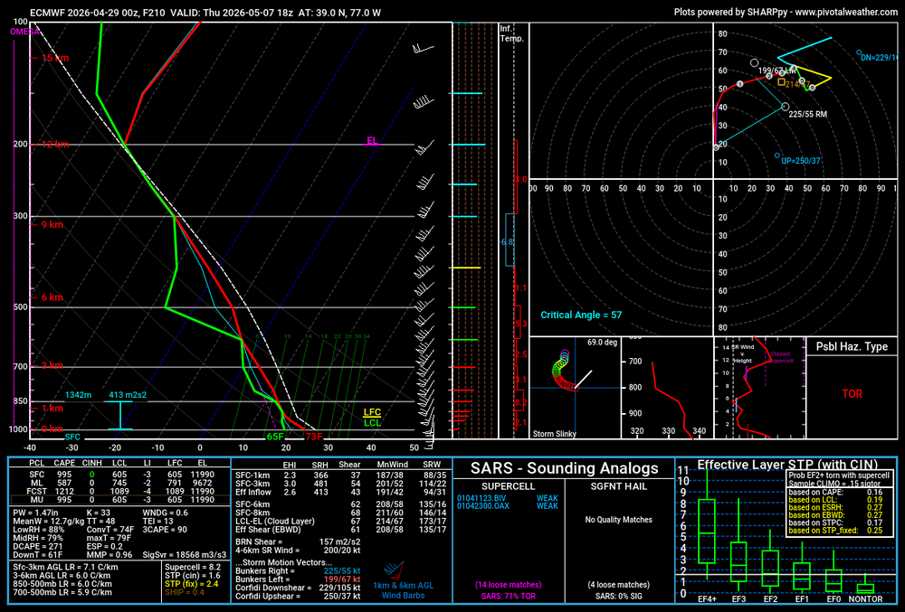
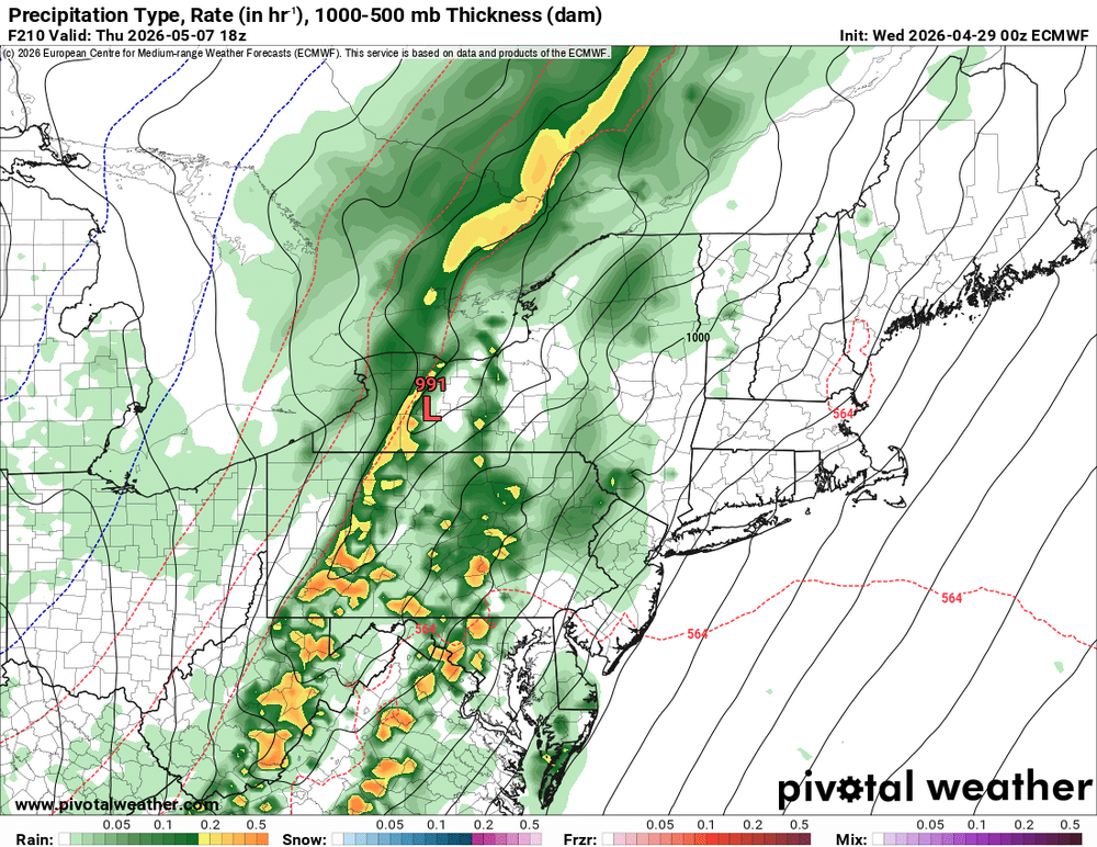
00z Euro had an interesting look for next Thursday. Decent shear and placement of the low, would like to see some more instability though. Still, its far out and possibly something to track over the next week.
- 295 replies
-
- 1
-
-
- severe
- thunderstorms
- (and 7 more)
-
Yeah big changes last couple days. We need the rain but even tonight's has been chopped back to .25-.50
-
Looks like the bleak long range forecast of clouds cool and showers has evaporated Mild actually this week with clouds but rainfall cut way back and sure a cool weekend coming up but 70s aplenty with a nice spring week to follow
- 946 replies
-
- 1
-

-
- april showers bring may..
- rain
- (and 2 more)


.png.613a0cb410cf366e592f8c6595870e07.png)


