Jump to content
  • Member Statistics

    18,283
    Total Members
    7,904
    Most Online
    happyclam13
    Newest Member
    happyclam13
    Joined

Tropical Depression Nine


WxWatcher007
 Share

Recommended Posts

56 minutes ago, wthrmn654 said:

Cmc and euro ai want to bring it to the Mid Atlantic/ north east before all is said and done...... that's after wandering off the south east.  


Will have to keep an eye on that to see off that becomes a thing or not. 

I say bring it. We definitely need some good rain here in Eastern PA.

Link to comment
Share on other sites

15 minutes ago, WxWatcher007 said:

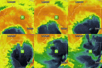
It looks like there may be enough of a wind shift to designate this at 11am. 

HNsXGN4.png

Yea this looks like a depression now or by 11 am as you said.  Humberto is pretty far away east from this system.


It’s obvious that Humberto turns out to sea gotta wait to see how high pressure builds into the Northeast and Mid Atlantic to put the block in place to initiate movement towards South Carolina, then the stall of Imelda, followed by the bounce off the high to the north and deflection out to sea.  Pretty simply put all about exact timing of players build and strength. 

Link to comment
Share on other sites

 The last frame of 6Z Euro has this stop its ENE movement and then suddenly drift back due W fwiw as Humberto accelerates away and the upper high builds enough to its N to change the steering. 

 Although this is the only major op doing this, 40% of the 6Z EPS do not escape and most of those stall not too far offshore and then attain a W component of motion.

  • Like 2
Link to comment
Share on other sites

2 minutes ago, GaWx said:

 The last frame of 6Z Euro has this stop its ENE movement and then suddenly drift back due W fwiw as Humberto accelerates away and the. the upper high builds enough to its N to change the steering. 

 Although this is the only major op doing this, 40% of the 6Z EPS do not escape and most of those stall not too far offshore and then attain a W component of motion.

And should that happen, the longitude of future Imelda will be key to whether this gets steered back to the coast or merely meanders until the trough eventually arrives to kick it into the North Atlantic. Like @donsutherland1 I’m skeptical of it getting steered back west right now but it’s on the table. 

  • Like 1
  • Thanks 1
Link to comment
Share on other sites

How about we keep the wishcasting and nonsense bust posting out of the thread? 

Recon just submitted a VDM. I think that should be enough for a designation at 11.

Product: NOAA Vortex Message (URNT12 KWBC)
Transmitted: 27th day of the month at 13:54Z
Agency: National Oceanic and Atmospheric Administration (NOAA)
Aircraft: Lockheed WP-3D Orion (Reg. Num. N42RF)
Storm Number & Year: 09L in 2025
Mission Identifier: Ptc09 (flight in the North Atlantic basin)
Mission Number: 11
Observation Number: 28 ( See all messages of this type for this mission. )

A. Time of Center Fix: 27th day of the month at 13:04:10Z
B. Center Fix Coordinates: 22.00N 76.00W
B. Center Fix Location: 129 statute miles (208 km) to the ENE (71°) from Camagüey, Cuba.
C. Minimum Height at Standard Level: 3,144m (10,315ft) at 700mb
D. Minimum Sea Level Pressure: 1007mb (29.74 inHg)
E. Dropsonde Surface Wind at Center: From 125° at 25kts (From the SE at 29mph)
F. Eye Character: Not Available
G. Eye Shape: Not Available
H. Estimated (by SFMR or visually) Maximum Surface Wind Inbound: Not Available
I. Location & Time of the Estimated Maximum Surface Wind Inbound (Undecoded): NA
J. Maximum Flight Level Wind Inbound: From 146° at 27kts (From between the SE and SSE at 31.1mph)
K. Location & Time of the Maximum Flight Level Wind Inbound: 8 nautical miles to the SE (135°) of center fix at 13:02:18Z
L. Estimated (by SFMR or visually) Maximum Surface Wind Outbound: Not Available
M. Location & Time of the Estimated Maximum Surface Wind Outbound (Undecoded): NA
N. Maximum Flight Level Wind Outbound: From 40° at 25kts (From the NE at 28.8mph)
O. Location & Time of the Maximum Flight Level Wind Outbound: 16 nautical miles (18 statute miles) to the NW (314°) of center fix at 13:08:03Z
P. Maximum Flight Level Temp & Pressure Altitude Outside Eye: 10°C (50°F) at a pressure alt. of 3,056m (10,026ft)
Q. Maximum Flight Level Temp & Pressure Altitude Inside Eye: 11°C (52°F) at a pressure alt. of 3,058m (10,033ft)
R. Dewpoint Temp (collected at same location as temp inside eye): 12°C (54°F)
R. Sea Surface Temp (collected at same location as temp inside eye): Not Available
S. Fix Determined By: Penetration, Wind, Pressure and Temperature
S. Fix Level: 700mb
T. Navigational Fix Accuracy: 0.01 nautical miles
T. Meteorological Accuracy: 1.5 nautical miles

Remarks Section:
 

Maximum Flight Level Wind: 27kts (~ 31.1mph) which was observed 8 nautical miles to the SE (135°) from the flight level center at 13:02:18Z
  • Like 1
  • Thanks 1
Link to comment
Share on other sites

1 hour ago, donsutherland1 said:

With the NHC now referring to Google DeepMind in some of its discussions, below is the latest Google DeepMind output for PTC9 at closest approach on the ensemble mean track:

image.thumb.png.aa63eb8312ff499bb0865c865a2bcd2a.png

I have mixed opinions on the NHC utilizing DeepMind during the infancy of the AI revolution.  It should absolutely be used as a tool, but Im not sure we are at the point where it should be used as a weighted metric in forecast discussions with the public.  


Model fatigue is a very real thing.  

  • Like 3
Link to comment
Share on other sites

8 minutes ago, dseagull said:

I have mixed opinions on the NHC utilizing DeepMind during the infancy of the AI revolution.  It should absolutely be used as a tool, but Im not sure we are at the point where it should be used as a weighted metric in forecast discussions with the public.  


Model fatigue is a very real thing.  

Agree.  I was surprised when I saw AI in their discussions earlier this year.  I'd keep it "in house" for a few years to establish some kind of track record.  So new and unproven.  They mention Google but nothing about any of the other AI guidance available.  I find that kind of odd as well.

  • Like 1
  • 100% 1
Link to comment
Share on other sites

39 minutes ago, MANDA said:

Agree.  I was surprised when I saw AI in their discussions earlier this year.  I'd keep it "in house" for a few years to establish some kind of track record.  So new and unproven.  They mention Google but nothing about any of the other AI guidance available.  I find that kind of odd as well.

LOL.  AT 11:00 A.M. they mention NOAA AIGEFS in the Humberto discussion.  First mention of another AI guidance I've seen.

Link to comment
Share on other sites

  • WxWatcher007 changed the title to Tropical Depression Nine

In defense of the ai models usage,  it's better this year then last year from what memory remembers.  . Idk how it has done with other storms, but with Erin the ai models track was so very much locked in from a very early start, from a rough aspect.  As with this storm i saw the euro ai first to show a glancing blow to Carolinas then loops/meander off the coast... way before other non ai models started... 

Do they have more data at there resources versus conventional models? Not sure but there deft is some kinda difference, likely not obvious to the naked eye. 

  • Like 1
Link to comment
Share on other sites

Time will certainly tell, with regard to AI integration.  Part of me is fearful that it will become "too good," eliminating the mystery and continuation of scientific analysis in forecasting.  Maybe another thread for this topic. 

I'm fascinated by the current forecast evolution of this particular complex setup.  This week will probably take the gold medal for most dynamic tropical forecast (regardless of land interaction,) in perhaps the past 2 seasons.  Fujiwara is a thread the needle interaction with actual tropical core systems.  Attempting to learn as much as I can over the next 72+ hours.   This was worth the wait. 

Link to comment
Share on other sites

Definitely seems like actual landfall is off the table thankfully. Still some uncertainty, but most models in agreement with it getting close, and then moving further off the coast. Coast still could get alot of rain though.

Link to comment
Share on other sites

Just like for all runs before, 12Z UK is again staying OTS from US with this run not as close to FL on its closest approach (175 miles offshore) vs last few runs:

TROPICAL DEPRESSION 09L ANALYSED POSITION : 22.0N 77.3W

ATCF IDENTIFIER : AL092025

LEAD CENTRAL MAXIMUM WIND
VERIFYING TIME TIME POSITION PRESSURE (MB) SPEED (KNOTS)
-------------- ---- -------- ------------- -------------
1200UTC 27.09.2025 0 22.0N 77.3W 1007 28
0000UTC 28.09.2025 12 21.3N 77.3W 1006 26
1200UTC 28.09.2025 24 23.4N 77.1W 1005 34
0000UTC 29.09.2025 36 24.7N 77.1W 1003 30
1200UTC 29.09.2025 48 26.2N 77.1W 1003 43
0000UTC 30.09.2025 60 27.5N 77.5W 1000 39
1200UTC 30.09.2025 72 28.3N 76.6W 997 35
0000UTC 01.10.2025 84 28.6N 74.6W 994 39
1200UTC 01.10.2025 96 34.6N 69.7W 977 69
0000UTC 02.10.2025 108 CEASED TRACKING
——————
 
*Edit: Note the initialization as of 12Z at 22.0N, 77.3W: how is that compared to where it really was at 8AM?


Link to comment
Share on other sites

 Note the 12Z UK initialization as of 12Z at 22.0N, 77.3W. It actually was per NHC ~21.7N, ~76W meaning it initialized ~100 miles too far WNW and still recurved pretty easily from US. That bodes well for chances for staying OTS from US.

Link to comment
Share on other sites

22 minutes ago, suzook said:

Definitely seems like actual landfall is off the table thankfully. Still some uncertainty, but most models in agreement with it getting close, and then moving further off the coast. Coast still could get alot of rain though.

100+ hours out in a complicated setup, wouldn’t be taking anything off the table completely like that just yet. 

  • 100% 4
Link to comment
Share on other sites

1. 12Z CMC stays OTS just like Icon, GFS, and UK

2. Anyone notice this? Based on the 11AM (15Z) NHC position of 76.2W on a NW heading, it appears to me that the model consensus 12Z initializations are ~35-100 miles too far W with them closer to 76.5-77.3W as of 12Z.

FORECAST POSITIONS AND MAX WINDS
 
INIT  27/1500Z 22.0N  76.2W   30 KT  35 MPH

Link to comment
Share on other sites

17 minutes ago, Newman said:

That 12Z GFS run definitely on the far western edge of the NHC cone and envelope, Florida East Coast most certainly gets in on outer rain bands in that scenario.

TS Watches are up along coastal Martin to Volusia counties in East-Central Florida (Melbourne CWA)

Yeah there are still some pretty substantial differences even at short(ish) range here. I don’t think there’s any one model that’s definitively right or wrong right now, though it’s obviously much higher confidence at the moment that there will be some kind of eastward turn at the coast. 

Link to comment
Share on other sites

44 minutes ago, NoCORH4L said:

She gone, unfortunately 

Tell you what. You come take your time in the barrel for a few late summers/early falls and then let us know how unfortunate it is that you don't get hit. 

  • Like 1
Link to comment
Share on other sites

Create an account or sign in to comment

You need to be a member in order to leave a comment

Create an account

Sign up for a new account in our community. It's easy!

Register a new account

Sign in

Already have an account? Sign in here.

Sign In Now
 Share

×
×
  • Create New...