Maggie Valley Steve
-
Posts
1,063 -
Joined
-
Last visited
Content Type
Profiles
Blogs
Forums
American Weather
Media Demo
Store
Gallery
Everything posted by Maggie Valley Steve
-

2026-2027 Fall/Winter Mountain Thread
Maggie Valley Steve replied to BlueRidgeFolklore's topic in Southeastern States
Flood threat increasing for some.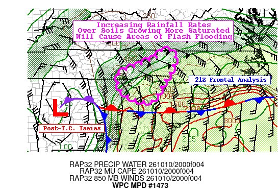
-
2026-2027 Fall/Winter Mountain Thread
Maggie Valley Steve replied to BlueRidgeFolklore's topic in Southeastern States
GSP just posted on X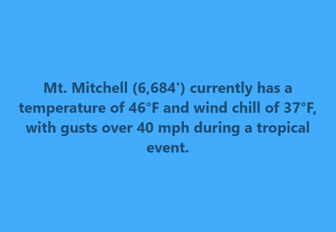
-
2026-2027 Fall/Winter Mountain Thread
Maggie Valley Steve replied to BlueRidgeFolklore's topic in Southeastern States
Just started pouring here with gusty winds. -
2026-2027 Fall/Winter Mountain Thread
Maggie Valley Steve replied to BlueRidgeFolklore's topic in Southeastern States
Looking like our first frost/freeze potential late next weekend. -
2026-2027 Fall/Winter Mountain Thread
Maggie Valley Steve replied to BlueRidgeFolklore's topic in Southeastern States
Mostly steady rain with breezes so far here at the house and 53°. I can hear stronger wind gusts higher up above the house and Popular trees are dumping leaves like crazy. This could mark an early end to leaf peeping season for a lot of areas. -
Stay safe down there Don. We're thinking about you from WNC.
-
2026-2027 Fall/Winter Mountain Thread
Maggie Valley Steve replied to BlueRidgeFolklore's topic in Southeastern States
GSP put out a nicely done informative discussion late this afternoon to their credit. It offered a lot of details regarding their reasoning and is worth the read. -
2026-2027 Fall/Winter Mountain Thread
Maggie Valley Steve replied to BlueRidgeFolklore's topic in Southeastern States
Fairly significant pressure drop recorded by RECON a couple of minutes ago. Looking more likely we have a CAT 4 now. -
2026-2027 Fall/Winter Mountain Thread
Maggie Valley Steve replied to BlueRidgeFolklore's topic in Southeastern States
Flood Watch issued for all of WNC including the Mountains. -
2026-2027 Fall/Winter Mountain Thread
Maggie Valley Steve replied to BlueRidgeFolklore's topic in Southeastern States
I was part of NWS chat for many years at HGX before moving up here. Keep us posted. -
2026-2027 Fall/Winter Mountain Thread
Maggie Valley Steve replied to BlueRidgeFolklore's topic in Southeastern States
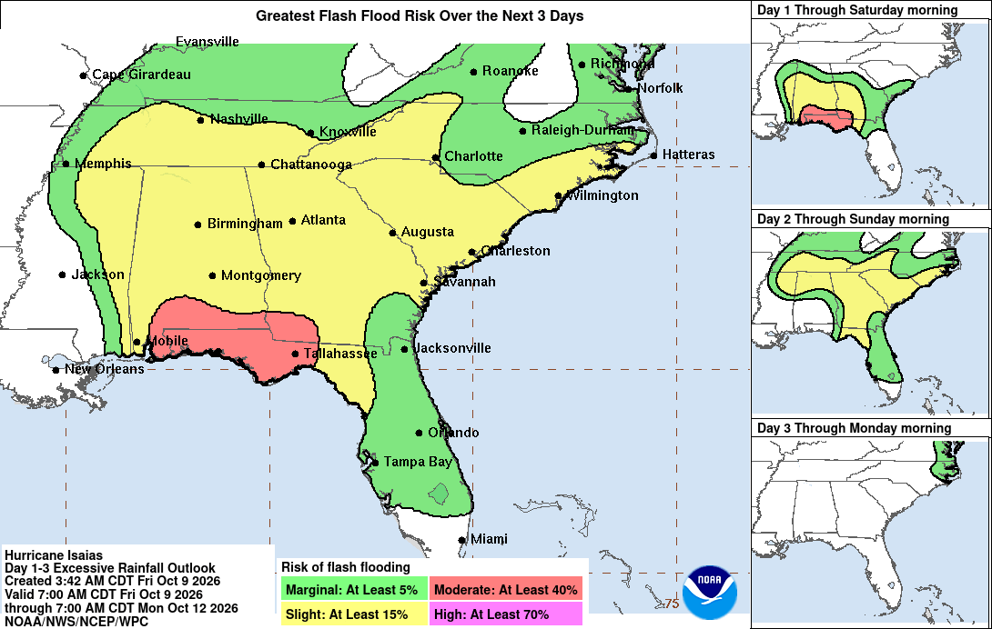
Updated Excessive Rainfall Outlook from the WPC. Folks need to be aware of the Flooding possibility with this storm.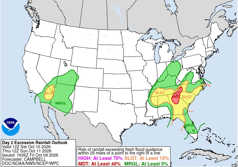
-
2026-2027 Fall/Winter Mountain Thread
Maggie Valley Steve replied to BlueRidgeFolklore's topic in Southeastern States
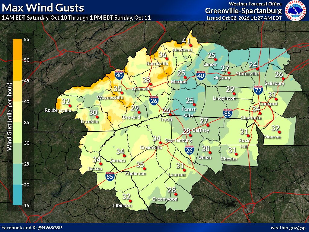
High Wind Warning hoisted for the WNC Mountains above 3500 ft from midnight tonight until Sunday morning. Wind Advisory hoisted for the Mountains below 3500 ft for the same timeframe..png.a0baffa2c63b26e25a2bc982982b6626.png)
-
2026-2027 Fall/Winter Mountain Thread
Maggie Valley Steve replied to BlueRidgeFolklore's topic in Southeastern States
They were holding off for another cycle of guidance to address the potential of a Flood Watch. They started that it was too early to address the wind threat with a Wind Advisory in their morning disco. Always too conservative in my opinion, but it is what it is. -
2026-2027 Fall/Winter Mountain Thread
Maggie Valley Steve replied to BlueRidgeFolklore's topic in Southeastern States
Isaias is now a Major Hurricane with sustained winds of 120 in and near the eyewall. Tropical Storm Force wind extend out just about 200 miles from the center. -
Yes they will Don. I wouldn't be surprised to see a Special Statement within the hour.
-
2026-2027 Fall/Winter Mountain Thread
Maggie Valley Steve replied to BlueRidgeFolklore's topic in Southeastern States
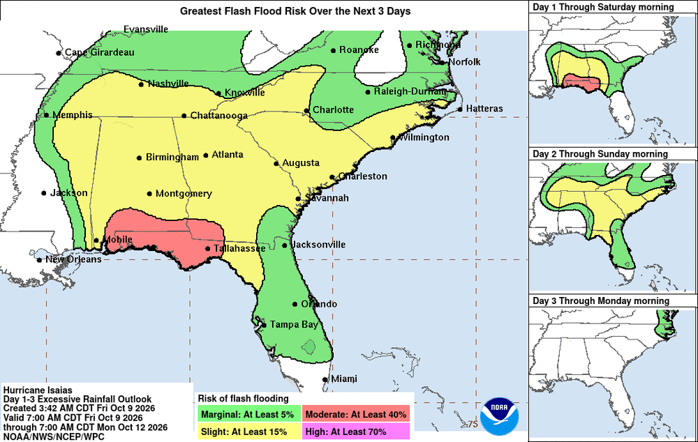
Isaias nearing Major Hurricane status per the NHC 5 AM advisory. They discussed some concerns on when strengthening wind shear actually begin to impact the cyclone. A 6 hour delay on the onset of shear could bring a Major Hurricane landfall near Pensacola/ Ft Walton Beach area late tonight or early tomorrow morning. Local impacts forecast has increased rainfall amounts along the Escarpment and winds may be higher in the Mountains than what GSP mentioned yesterday. GSP in their morning disco mentioned that a Flood Watch might be needed later today. Also, there is a possibility of Wind Advisory tomorrow morning for the Mountains..thumb.png.66509fa4742d685a2d711ebb571f2e43.png)
-
2026-2027 Fall/Winter Mountain Thread
Maggie Valley Steve replied to BlueRidgeFolklore's topic in Southeastern States
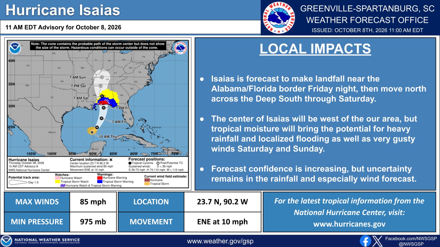
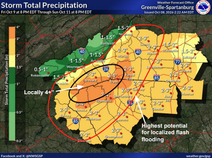
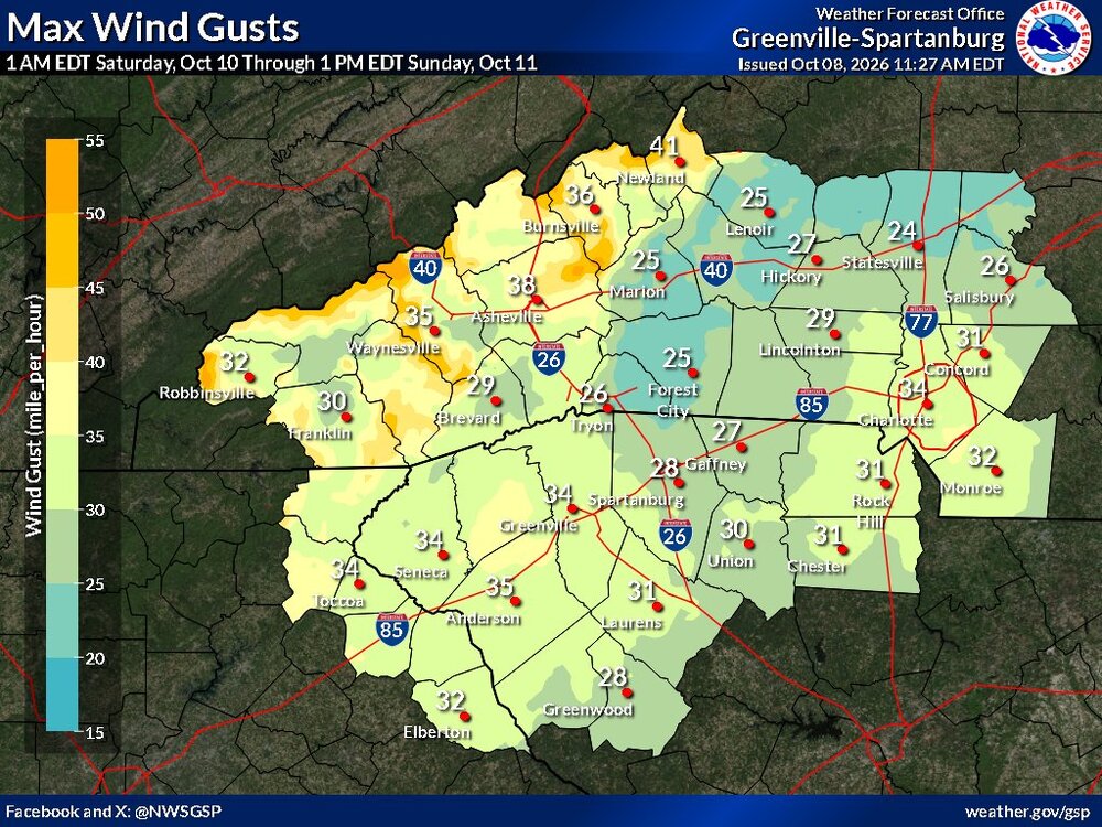
GSP updated information just posted.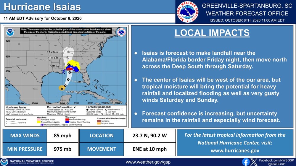
-
2026-2027 Fall/Winter Mountain Thread
Maggie Valley Steve replied to BlueRidgeFolklore's topic in Southeastern States
I don't see that much change in my thinking on rainfall amounts for the Mountains. I am seeing some indication of higher winds, particularly for the Ridgeline and the Valleys as Isaias is absorbed by the trough and transitions into an upper low. Wind gusts to 50 look possible along the Ridges and in the Valley areas gusts to 40 could be possible.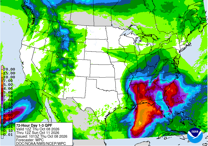
-
2026-2027 Fall/Winter Mountain Thread
Maggie Valley Steve replied to BlueRidgeFolklore's topic in Southeastern States
The 5PM Update shows Isaias stronger with sustained winds of 65. Tropical Storm Force wind extend out 60 miles from the center. The track was adjusted further E giving a nod to the AI guidance.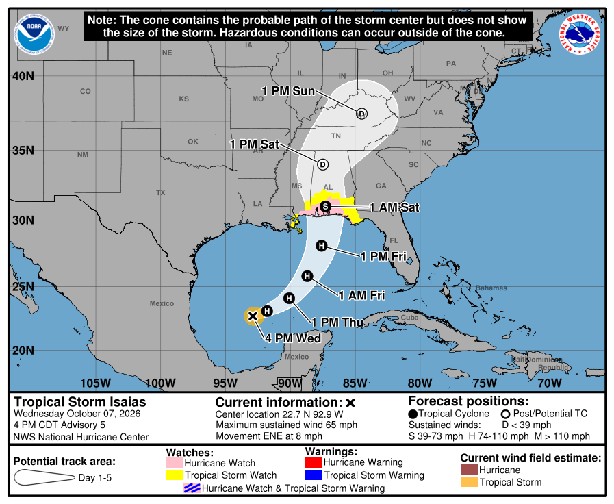
-
2026-2027 Fall/Winter Mountain Thread
Maggie Valley Steve replied to BlueRidgeFolklore's topic in Southeastern States
I'm not to concerned about a significant wind threat at this time as Isaias will likely have transitioned to Extra Tropical by the time it makes it to our latitude. Looks like less than an inch near the border and 1 to 3 inches along the Escarpment with a couple of isolated total of 4 to 6 inches in upslope areas. A weak cold front arrives Friday setting up CAD that actually could reduce rainfall amounts. The highest gusts I'm currently seeing are in to 30 to 35 range. I'll take a closer look in the morning for our local Region. -
2026-2027 Fall/Winter Mountain Thread
Maggie Valley Steve replied to BlueRidgeFolklore's topic in Southeastern States
Afternoon updated 5 Day QPF forecast is out.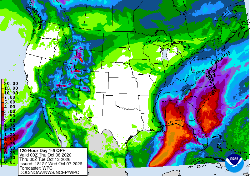
-
2026-2027 Fall/Winter Mountain Thread
Maggie Valley Steve replied to BlueRidgeFolklore's topic in Southeastern States
45 at the house this morning. TS Isaias is strengthening fairly quickly overnight ahead of schedule and the forecast track has shifted E to near Mobile Bay. NHC in their 5 AM discussion stated that the track could shift further E later today and Hurricane Watches are likely this afternoon along portions of the Northern Gulf Coast. Both Air Force and NOAA aircraft will begin low level sampling missions today. -
2026-2027 Fall/Winter Mountain Thread
Maggie Valley Steve replied to BlueRidgeFolklore's topic in Southeastern States
TD 9 was designated by the NHC at 5:00 PM. Currently a high altitude G-IV mission is underway sampling along the Gulf Coast and SE. That new data should be ingested into the 00Z of dynamical models. -
2026-2027 Fall/Winter Mountain Thread
Maggie Valley Steve replied to BlueRidgeFolklore's topic in Southeastern States
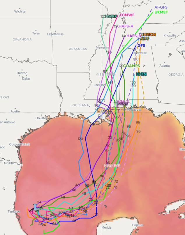
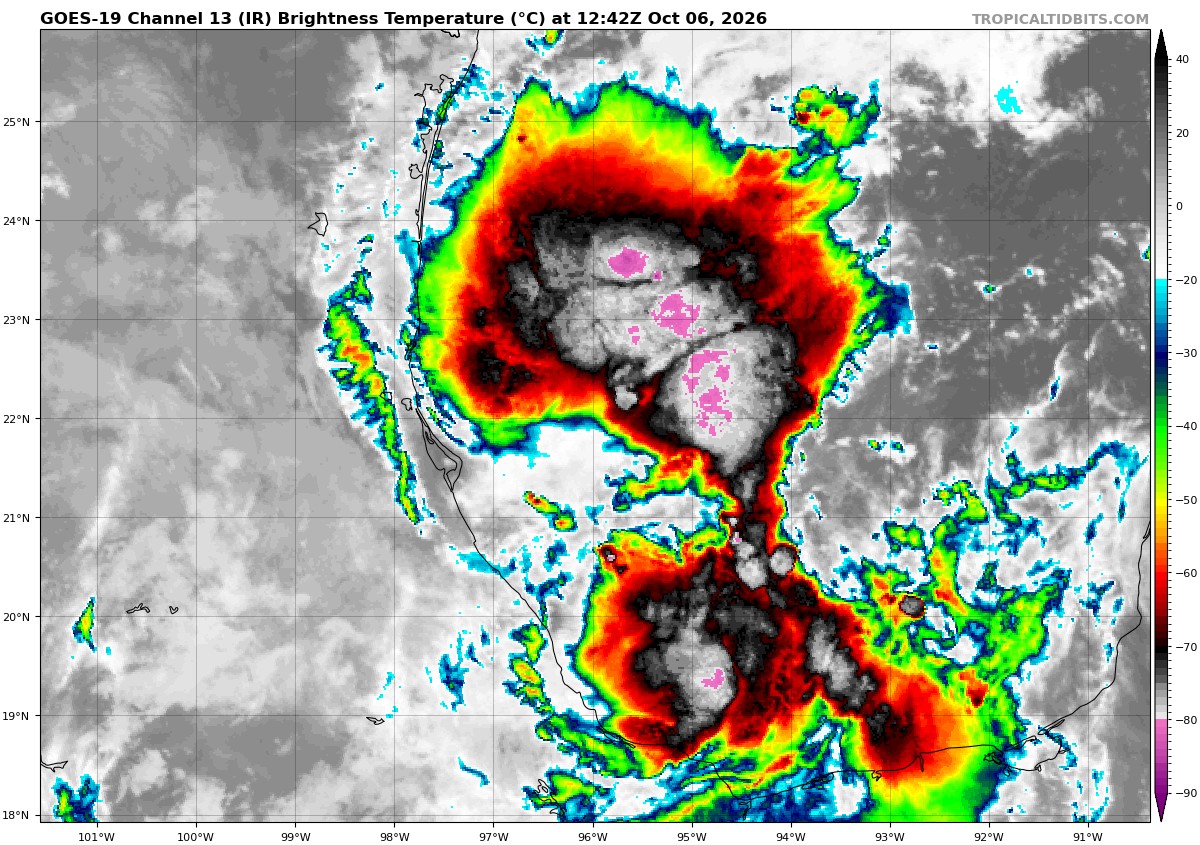
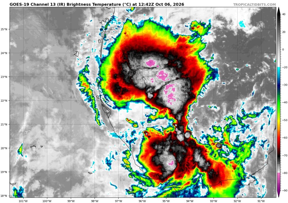
92L in the Bay of Campeche is looking better today with deep thunderstorms and appears likely that a Hurricane will develop later this week, possibly early this weekend in the Gulf. Hurricane models suggest landfall along the Central Gulf Coast with Google Deep Mind ensembles clustered further East near the Florida Panhandle. Rain chances do look to increase over the weekend locally.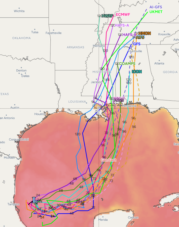
-
2026-2027 Fall/Winter Mountain Thread
Maggie Valley Steve replied to BlueRidgeFolklore's topic in Southeastern States
43 this morning. The Popular trees started dumping yesterday. Everyday there is more colors around the Valley.


.png.3bf87fd5e0a37834bfb55f38a8e0141c.png)