

Maggie Valley Steve
-
Posts
979 -
Joined
-
Last visited
Content Type
Profiles
Blogs
Forums
American Weather
Media Demo
Store
Gallery
Everything posted by Maggie Valley Steve
-

2026 Spring/Summer Mountain Thread
Maggie Valley Steve replied to Buckethead's topic in Southeastern States
Frost Advisory and Freeze Warning issued for the Mountains.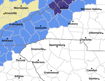
-
2026 Spring/Summer Mountain Thread
Maggie Valley Steve replied to Buckethead's topic in Southeastern States
Clouds have rolled in now, but what a beautiful morning and mid day we've had. I had a low of 41 this morning. We'll see if we make a run at the mid 30's Sunday morning! -
2026 Spring/Summer Mountain Thread
Maggie Valley Steve replied to Buckethead's topic in Southeastern States
Yeah and a slight chance at some wet snow at the highest elevations Saturday night. -
2026 Spring/Summer Mountain Thread
Maggie Valley Steve replied to Buckethead's topic in Southeastern States
What a glorious morning! Lots of lightening and thunder and a round of heavy rain around 5 o'clock this morning. Certainly the rain over performed and it was surely needed! -
2026 Spring/Summer Mountain Thread
Maggie Valley Steve replied to Buckethead's topic in Southeastern States
We've had a nice week with cool mornings and warm Spring days. It's looking that a pattern change is ahead with rain chances returning tomorrow continuing into next week. -
2026 Spring/Summer Mountain Thread
Maggie Valley Steve replied to Buckethead's topic in Southeastern States
I got enough rain to wash down the pollen! 53 this morning. -
2026 Spring/Summer Mountain Thread
Maggie Valley Steve replied to Buckethead's topic in Southeastern States
Frost Advisory hoisted for tonight/tomorrow morning. -
2026 Spring/Summer Mountain Thread
Maggie Valley Steve replied to Buckethead's topic in Southeastern States
I ended up with an inch of rain and I am very thankful! The pollen has been washed down and cooler air is filtering in. I could make a run at freezing in the morning. We'll see about that. -
2026 Spring/Summer Mountain Thread
Maggie Valley Steve replied to Buckethead's topic in Southeastern States
Please hid my thread Michelle. I'll gladly take a little less than an inch out of the front. Here's to a typical Season with no damaging Tropical Mischief! -
2025-2026 Fall/Winter Mountain Thread
Maggie Valley Steve replied to Buckethead's topic in Southeastern States
For me it was an A. I had a little over 23 inches of snow for the Fall/Winter Season which is 3 time the average snowfall for my area of Haywood County. -
2025-2026 Fall/Winter Mountain Thread
Maggie Valley Steve replied to Buckethead's topic in Southeastern States
Spring is fully underway around the house. Japanese Red Maples are putting out leaves and the Polar is buding. Finally getting showers this afternoon! Time to start a Spring/Summer Thread! -
2025-2026 Fall/Winter Mountain Thread
Maggie Valley Steve replied to Buckethead's topic in Southeastern States
I had a brief sprinkle earlier and it doesn't look encouraging ahead of the Canadian front. Hopefully we will do better late next week when the the ridge breaks down. -
2025-2026 Fall/Winter Mountain Thread
Maggie Valley Steve replied to Buckethead's topic in Southeastern States
37 this morning in the Valley. Definitely an inversion this morning. Looks like a shot of rain Friday afternoon/evening with the arrival of a Canadian front. A freeze looks likely Sunday morning across the Mountains. -
Roger was a staple around here and Eastern WX. Sorry to here this. God Bless his family.
-
2025-2026 Fall/Winter Mountain Thread
Maggie Valley Steve replied to Buckethead's topic in Southeastern States
High of 35 and the mid March sun just about melted all the snow on my N facing mountain. Currently 29. I expect my low tomorrow morning to be in the upper teens again. We'll see what the clipper can deliver tomorrow. My hunch is it will be too dry at the surface for anything to make to the ground. -
2025-2026 Fall/Winter Mountain Thread
Maggie Valley Steve replied to Buckethead's topic in Southeastern States
Surprisingly I'm still get light flurries in this flow setup. -
2025-2026 Fall/Winter Mountain Thread
Maggie Valley Steve replied to Buckethead's topic in Southeastern States
Looks like I added an inch after the wind layed down overnight. About 3 inches so far. Light flurries and 19. -
2025-2026 Fall/Winter Mountain Thread
Maggie Valley Steve replied to Buckethead's topic in Southeastern States
Nearing 22 inches for the season so far. It's still snowing. Our average is 7 inches. -
2025-2026 Fall/Winter Mountain Thread
Maggie Valley Steve replied to Buckethead's topic in Southeastern States
These snow squalls mean business! Getting a lot of gusts near 45 mph now with blowing moderate to heavy snow at times. -
2025-2026 Fall/Winter Mountain Thread
Maggie Valley Steve replied to Buckethead's topic in Southeastern States
Flow snow is fully underway in the Valley with this westerly component. We had some breaks in the clouds earlier, but visibility is back down to 1/2 a mile with gusty winds and moderate snow showers. -
2025-2026 Fall/Winter Mountain Thread
Maggie Valley Steve replied to Buckethead's topic in Southeastern States

-
2025-2026 Fall/Winter Mountain Thread
Maggie Valley Steve replied to Buckethead's topic in Southeastern States
And just like that the ground is white. -
2025-2026 Fall/Winter Mountain Thread
Maggie Valley Steve replied to Buckethead's topic in Southeastern States
Moderate to heavy snow with winds gusting to 40. Visibility down to a quarter mile. 28 degrees. -
2025-2026 Fall/Winter Mountain Thread
Maggie Valley Steve replied to Buckethead's topic in Southeastern States
Down to flurries, but the wind is starting to whip and temperature is down to freezing. Radar suggests flow snow from the West is developing in Eastern Tennessee along the Smokies. -
2025-2026 Fall/Winter Mountain Thread
Maggie Valley Steve replied to Buckethead's topic in Southeastern States
Moderate snow with some occasional bouts of heavy snow and huge flakes. NCDOT is working up Soco Rd towards the Gap.

