Maggie Valley Steve
-
Posts
507 -
Joined
-
Last visited
About Maggie Valley Steve

Recent Profile Visitors


-

2025 Spring/Summer Mountain Thread
Maggie Valley Steve replied to Maggie Valley Steve's topic in Southeastern States
We got a sprinkle after thundering for an hour. I'm not complaining. We had mostly light to moderate rain most of the afternoon yesterday. I just do not see any relaxing of this persistent pattern into the end of the month. It's less than 70 days before Fall arrives! -
2025 Spring/Summer Mountain Thread
Maggie Valley Steve replied to Maggie Valley Steve's topic in Southeastern States
Good luck and best wishes on your life move! Looking forward to your pictures and reports from the Big Sky Country. -
2025 Spring/Summer Mountain Thread
Maggie Valley Steve replied to Maggie Valley Steve's topic in Southeastern States
We're finally getting storms late this evening! -
2025 Spring/Summer Mountain Thread
Maggie Valley Steve replied to Maggie Valley Steve's topic in Southeastern States
I finally got a tenth of an inch of rain today. It's starting to get mighty dry around the Valley. Hopefully we'll see more chances the next several days. -
2025 Spring/Summer Mountain Thread
Maggie Valley Steve replied to Maggie Valley Steve's topic in Southeastern States
I am heartbroken for the folks back in the Texas Hill Country. I grew up visiting many of these areas in my early years into late teens. Loss of life from flooding is imprinted in our minds and burned into our hearts here in Western NC from Helene. So many young kids is almost too difficult to fathom from Hunt TX area. -
2025 Spring/Summer Mountain Thread
Maggie Valley Steve replied to Maggie Valley Steve's topic in Southeastern States
I had a nice half hour shower today, but no thunder. Tomorrow looks similar. Tuesday we should get a front drifting in from the NW. Not sure how much progress it makes, but hopefully some drier air arrives for the Forth of July Fireworks across the area! -
2025 Spring/Summer Mountain Thread
Maggie Valley Steve replied to Maggie Valley Steve's topic in Southeastern States
I finally got some rain last evening! My low this morning was 60 which felt so refreshing after a few days of very warm weather. -
2025 Spring/Summer Mountain Thread
Maggie Valley Steve replied to Maggie Valley Steve's topic in Southeastern States
Another day of noisy thunderstorms all around and not a drop of rain. -
2025 Spring/Summer Mountain Thread
Maggie Valley Steve replied to Maggie Valley Steve's topic in Southeastern States
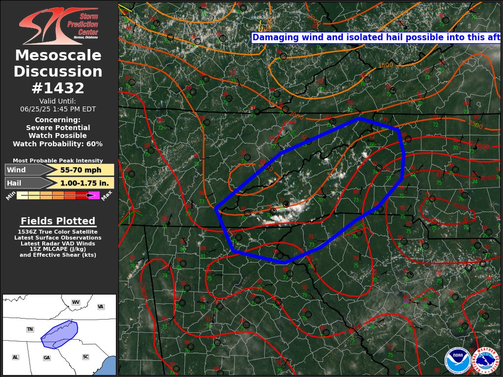
Mesoscale Discussion out for the Mountains.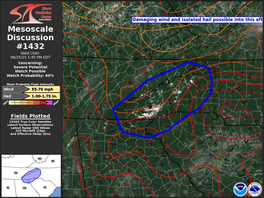
-
2025 Spring/Summer Mountain Thread
Maggie Valley Steve replied to Maggie Valley Steve's topic in Southeastern States
We had a lot of thunder but no rain. Temperature did drop from 87 to 77 in an hour and it's currently 73. If the Slight Risk holds tomorrow, fingers crossed we get some rain locally. -
2025 Spring/Summer Mountain Thread
Maggie Valley Steve replied to Maggie Valley Steve's topic in Southeastern States
Pulse storms are popping this afternoon for Mountain Folk. Hopefully we'll see some cooling rain locally after a high of 88. -
2025 Spring/Summer Mountain Thread
Maggie Valley Steve replied to Maggie Valley Steve's topic in Southeastern States
87 currently at the house @ 3300 ft -
2025 Spring/Summer Mountain Thread
Maggie Valley Steve replied to Maggie Valley Steve's topic in Southeastern States
I'm getting alerts from Haywood County about a rock slide near the border on I-40 due to very heavy rainfall. I -40 has been closed both ways. I drove through the Gorge Sunday afternoon and it took me an hour and twenty minutes to get through from the Tennessee side. -
2025 Spring/Summer Mountain Thread
Maggie Valley Steve replied to Maggie Valley Steve's topic in Southeastern States
Thunderstorms teased me earlier this evening, but I'm finally reaping the benefits of cells nearby. -
2025 Spring/Summer Mountain Thread
Maggie Valley Steve replied to Maggie Valley Steve's topic in Southeastern States
It looks like some scattered storms are nearing the border this evening. The models are struggling with the various MCS possibilities over the next several days. The front seems to be meandering across the Virginia's and Eastern Kentucky currently. It's been a minute since we had some rain locally.