Maggie Valley Steve
-
Posts
967 -
Joined
-
Last visited
Content Type
Profiles
Blogs
Forums
American Weather
Media Demo
Store
Gallery
Everything posted by Maggie Valley Steve
-

2026 Spring/Summer Mountain Thread
Maggie Valley Steve replied to Buckethead's topic in Southeastern States
Looks like storms are headed our way tonight. Keep the Eastern trough coming! -
2026 Spring/Summer Mountain Thread
Maggie Valley Steve replied to Buckethead's topic in Southeastern States
After another round of thunderstorms overnight, another chance today with rainfall rates up to 3 inches per hour are possible.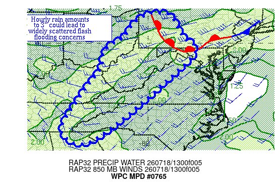
-
2026 Spring/Summer Mountain Thread
Maggie Valley Steve replied to Buckethead's topic in Southeastern States
It's been raining and thundering the past hour with gusty winds and occasional heavy rainfall rates. Currently 70 with moderate rain. -
2026 Spring/Summer Mountain Thread
Maggie Valley Steve replied to Buckethead's topic in Southeastern States
Showers were nearby today and mostly cloudy skies held my temperature in the low 80's. It sure looks like the Eastern trough will become active into the end of July. I'll take a mid summer pattern like that offering rain chances nothing too hot any day! -
2026 Spring/Summer Mountain Thread
Maggie Valley Steve replied to Buckethead's topic in Southeastern States
It was good to see the Sun today! Clouds built in around lunch time and kept temperatures in the upper 70's. Not bad for the middle of July. -
2026 Spring/Summer Mountain Thread
Maggie Valley Steve replied to Buckethead's topic in Southeastern States
It looks like an unsettled pattern will continue this week into the weekend. For the Mountains, high temperatures should remain mostly in check throughout the period with daily storms. We'll need to monitor the weekend as there appears to be potential for a tropical disturbance attempting to organize along the Northern Gulf or off the West Coast of Florida along the stalled frontal boundary to our South. -
2026 Spring/Summer Mountain Thread
Maggie Valley Steve replied to Buckethead's topic in Southeastern States
I'm getting a little concerned with the repeated rounds of heavy rain. The WPC has concerns also.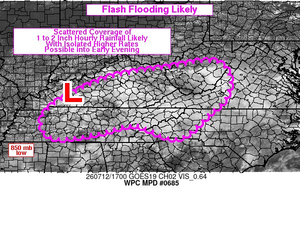
-
2026 Spring/Summer Mountain Thread
Maggie Valley Steve replied to Buckethead's topic in Southeastern States
Looks like another Mesoscale Convective System is heading our way from Central Tennessee tonight. -
2026 Spring/Summer Mountain Thread
Maggie Valley Steve replied to Buckethead's topic in Southeastern States
Happy Birthday Buckethead! -
2026 Spring/Summer Mountain Thread
Maggie Valley Steve replied to Buckethead's topic in Southeastern States
No rain today, but it was a little drier and a bit cooler. My high temperature was 82. Storms are still firing along the Tennessee border so maybe a nighttime shower is ahead. -
2026 Spring/Summer Mountain Thread
Maggie Valley Steve replied to Buckethead's topic in Southeastern States
It never hit 80 here at the house today. Clouds began bubbling around lunch time and off an on showers during the afternoon. -
2026 Spring/Summer Mountain Thread
Maggie Valley Steve replied to Buckethead's topic in Southeastern States
We've been getting a thundershowers the past half hour. Happy Birthday America! -
2026 Spring/Summer Mountain Thread
Maggie Valley Steve replied to Buckethead's topic in Southeastern States
Clouds have moved in and the temperature is dropping off after a high of 87. Hearing a lot of thunder off to my West. -
2026 Spring/Summer Mountain Thread
Maggie Valley Steve replied to Buckethead's topic in Southeastern States
88 for my high today. -
2026 Spring/Summer Mountain Thread
Maggie Valley Steve replied to Buckethead's topic in Southeastern States
85 here, but very little humidity. Makes for a pleasant evening for our 250 Independence Day celebration! -
2026 Spring/Summer Mountain Thread
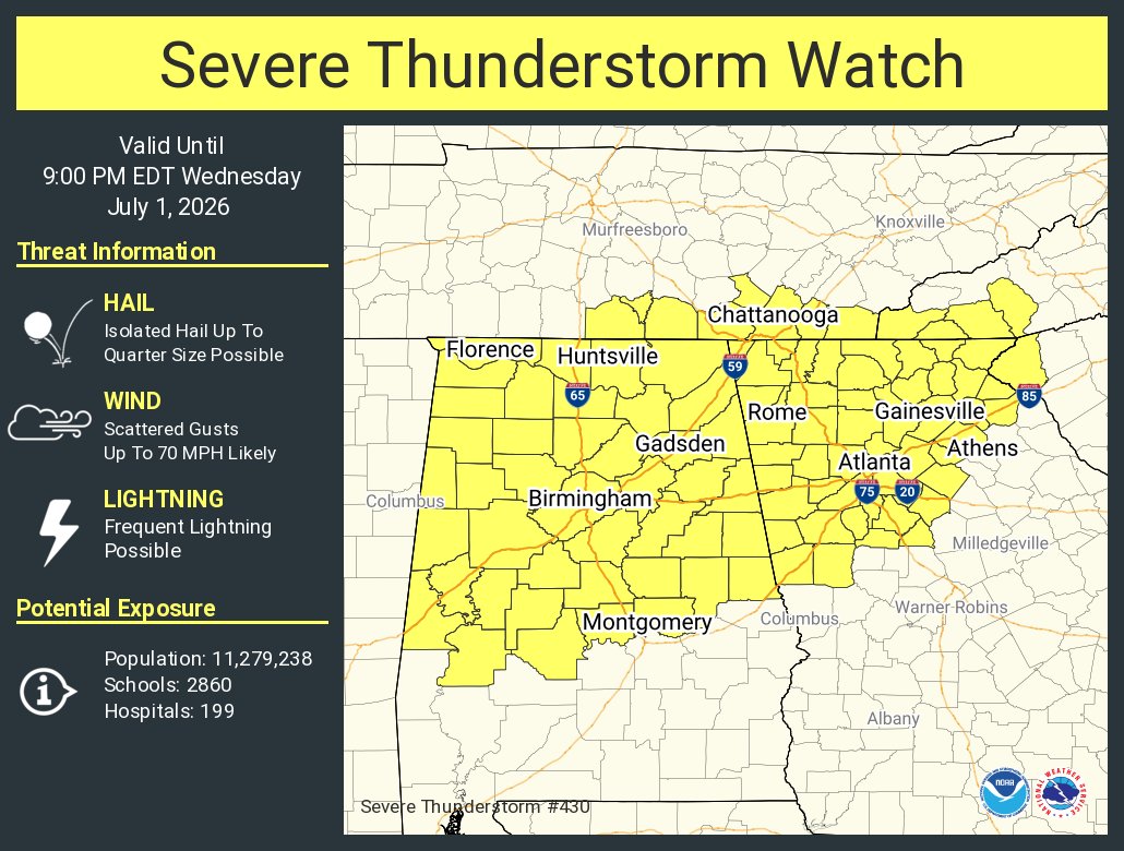
Maggie Valley Steve replied to Buckethead's topic in Southeastern States
Severe Thunderstorm Watch for portions of the SW Mountains.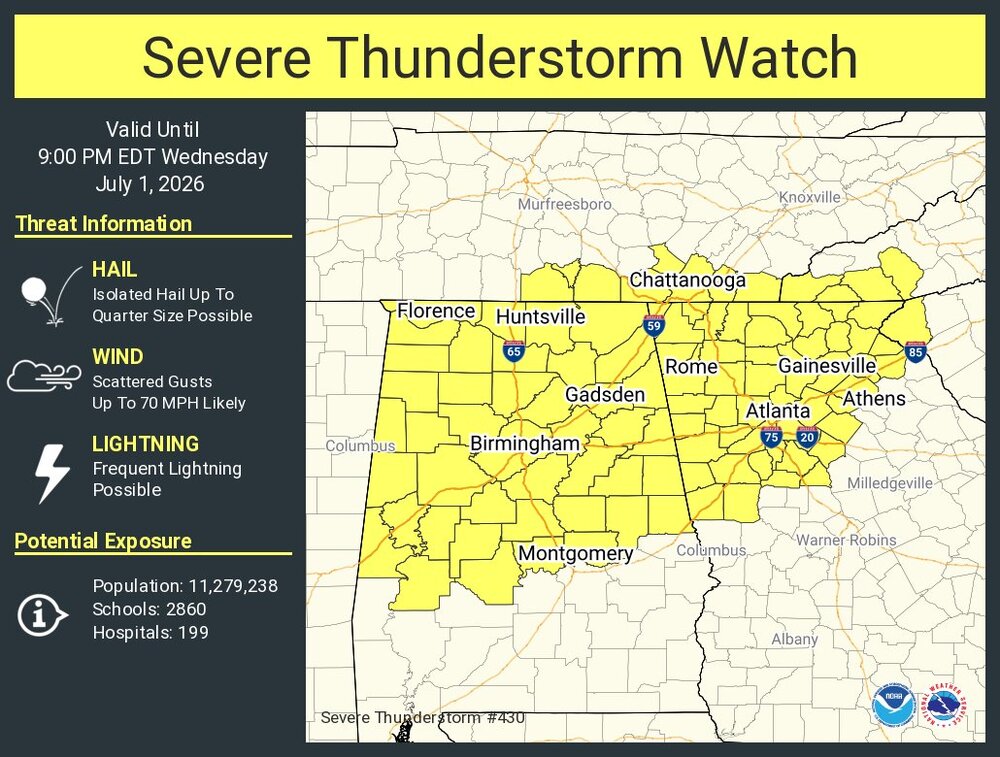
-
2026 Spring/Summer Mountain Thread
Maggie Valley Steve replied to Buckethead's topic in Southeastern States
83 again today for my high. Much cooler this morning with a 65 than the day before. I see signs in the medium to longer range a general troughiness over head. Once we get past Independence Day I believe a more unsettled pattern sets in. -
2026 Spring/Summer Mountain Thread
Maggie Valley Steve replied to Buckethead's topic in Southeastern States
83 for my high temp this afternoon and no rain here today. Congratulations Buckethead! -
Worse for me today Larry!
-
Mid-Long Range Discussion 2026
Maggie Valley Steve replied to BooneWX's topic in Southeastern States
@Wow -
Same problem today, particularly slow loading.
-
2026 Spring/Summer Mountain Thread
Maggie Valley Steve replied to Buckethead's topic in Southeastern States
I had a low of 53 this morning. What a way to run Summer in the Mountains! -
2026 Spring/Summer Mountain Thread
Maggie Valley Steve replied to Buckethead's topic in Southeastern States
Heavy rain in the Valley. -
2026 Spring/Summer Mountain Thread
Maggie Valley Steve replied to Buckethead's topic in Southeastern States
Happy Summer Solstice! It's all downhill from here until Fall! -
2026 Spring/Summer Mountain Thread
Maggie Valley Steve replied to Buckethead's topic in Southeastern States
I just emptied 1.79 inches out of the gage this morning. Not bad at all for yesterday's beneficial rain!