All Activity
- Past hour
-

E PA/NJ/DE Summer 2026 Obs/Discussion
LVblizzard replied to PhiEaglesfan712's topic in Philadelphia Region
I’m a little surprised we’re still under a slight risk for Thursday. The timing of the front and associated storms looks like it’ll be in the late morning/early afternoon, which is too early for instability to really do its thing. It does still look like we’ll get some rain at least which is very helpful, especially for the areas that got shafted on Sunday. -
It usually only happens in the spring, and stops around Chicago due to easterly component off Lake MI even then. I haven’t been paying attention because it’s just going to a chilly stratiform rainer with an embedded rumble or two IMBY.
-
Had a few quarter sized stones hit my sliding door around 4:30 PM. Most of the stones were probably .5” and soft looking, but some close to 1” were mixed in. I could definitely hear the bigger harder ones hitting sporadically. Had to warm my parents who live 1 mile away to protect their cars. No severe warning for this cell. I guess it’s hard to see a hail core very close to the radar.
-
Cloudy with a high of 85. Very humid out there though. Dew points in the mid 70's.
-
Our temperature has actually dipped about 5 degrees from 12:30-4:30 PM here today. Falling afternoon temps are hard to achieve without precipitation this time of the year.
-
If I drive 12hrs everyone will be below 90F because it’ll be 2am.
-
hope you get a banger
-

Sweet Pic Of A Rose In My Back Yard
PhiEaglesfan712 replied to Coach McGuirk's topic in Outdoor and Weather Photography
-
Could use more rain, but temps not bad. Worse of the heat behind us?
-
tbh, i believe tomorrow will pale in comparison to last thursday in illinois. that's my hunch.
-

2026 Mid-Atlantic Severe Storm General Discussion
high risk replied to Kmlwx's topic in Mid Atlantic
18z NAM Nest is the first really encouraging run for Thursday. It also seems to justify the outlook for tonight. - Today
-
The Midwest is going to have a Deep South outbreak on Wednesday, with fast storm motion and low LCLs. At least their trees aren’t as bad. Oh but we love battling trees, lol! And we don’t have Midwest chaser convergence. Enter the Southeast on Thursday! Remnant of PTC 1 (perhaps Arthur) will scoot from Mississippi through Alabama into Georgia. Despite hideous terrain, it’s close. From SPC Day 3 Southeast... The remnants of Potential Tropical Cyclone 1 will continue to move through the northern Gulf into the Southeast on Thursday. With 70+ dewpoints likely to be ahead of this feature, even muted surface heating will promote moderate instability will develop. With locally enhanced shear near the remnant low, isolated strong wind gusts and perhaps a tornado or two will be possible. Should greater destabilization occur, higher probabilities could be warranted.
-
I've never been there during the warm seasons. I do my hiking during winter. Colder the better. I've done all the popular hikes, but without seeing a soul. I hiked to Annopoils Rocks and back from route 40 in 2014. It was -5 at the trailhead and probably -8 or -9 at the rocks. I didn't see one single soul. I've been to Cunningham Falls twice and never saw anyone. The Falls were frozen. It was really cool. I love extreme winter conditions for my hikes. I like to hike on top of the Catoctins during the windiest days of winter. I've got all kinds of stories lol Ridiculously beautiful day today. Unreal
-
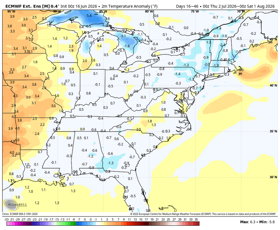
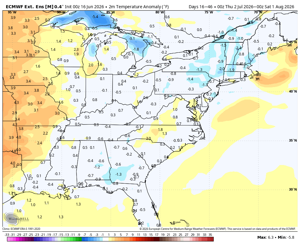
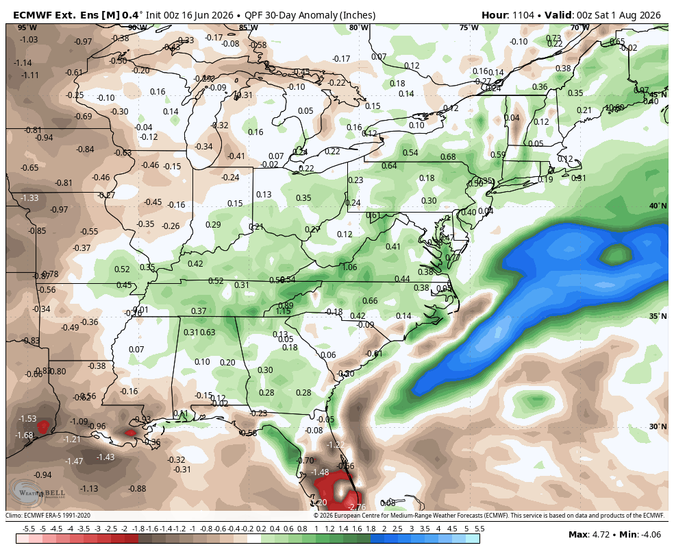
WB latest EURO extended weeklies for July.

- 158 replies
-
- 1
-

-
- we got burned
- rugpull central
- (and 1 more)
-
Hello everyone. Half the year is over. Here's hoping we can get one decent winter storm this winter. Its always fun to track them but its always about timing
- 271 replies
-
- 1
-

-
- severe
- mountain snow
- (and 1 more)
-
Im cautiously optimistic that we can get one decent winter storm this upcoming winter. Should have an active southern branch and hopefully we have enough cold air. I live in west tennessee and typically we get one event and the occasional 2 events. All about timing
-
51 this morning. 79 today. Absolutely beautiful
-
Hit a high on 69 today!!!! Half inch of rain so far. Miserable day. More of the same until the weekend.
-
No doubt. If Reed Timmer sets up shop somewhere around here, we know we’re in the bullseye. What an incredible setup tomorrow.
-
This is awesome! I've had the windows open all day, now sunny and 77. Gonna be a great porch evening. Hoping for some overnight showers with the warm front
-
Same my dude. Had the IKK/Aroma Park/Lake Village near miss and then this past Thursday was also a near miss for me Really dodging bullets here in east central IL
-
Legit a little anxious/worried for tomorrow.
-
I was just a period of short heavy rain and lightning/thunder when it came through my area.
-
looks like a good hail core on that cell NE of grand rapids
-
A sounding from eastern Illinois from the 18z NAM...a bit of a cap around 700mb but this is an extremely scary profile. You put a mature supercell into this environment and there is absolute concern for a long tracked tornado


.thumb.jpg.ad3a2e31d30aff035044689b311a0540.jpg)
