All Activity
- Past hour
-
just give up on winter
-
Temperature Forecast Fail
-
Looks like another cold front will stall across/just south of us end of the week. That could mean clouds with periods of showers through the weekend.
-
I would love a direct train to Baltimore Sent from my SM-G970U using Tapatalk
-
morning popcorn, feels like mid summer already
-

Extended summer stormlover74 future snow hole banter thread 23
LibertyBell replied to BxEngine's topic in New York City Metro
wow thanks Don, these are absolutely amazing! -
Seems like it's just some fog that needs to burn off. As for the pattern flipping to warm/dry for a long stretch...I'd bet on mid-December.
-
Great weather to start the week as long as allergies are not a problem! We should see temps well into the 70's today and 80's tomorrow. Next shot at showers looks to be around Thursday. Chester County wide records for today: High 98 degrees at West Chester (1962) / Low 32 degrees also at West Chester (2002) / Rain 4.89" at Coatesville 1SW (1894)

-

E PA/NJ/DE Spring 2024 OBS/Discussion
ChescoWx replied to Hurricane Agnes's topic in Philadelphia Region
Great weather to start the week as long as allergies are not a problem! We should see temps well into the 70's today and 80's tomorrow. Next shot at showers looks to be around Thursday. Chester County wide records for today: High 98 degrees at West Chester (1962) / Low 32 degrees also at West Chester (2002) / Rain 4.89" at Coatesville 1SW (1894)
-
Another cloudy damp morning. I don't remember ever going this long without a sunny day. It's been sunny twice this month. Does anyone know when this damp shitty pattern is going to break?
-
What an advertisement for the LSV. Perhaps one of our red-taggers who turned into a realtor could use that quote.
- Today
-
A friend lives there and her last Facebook post last night were that the sirens were going off. She hasn't updated yet if she's ok.
-
Thursday sounds interesting... from this mornings AFD .LONG TERM /THURSDAY THROUGH SUNDAY/... To the south of a deep upper trough tracking across Quebec will be a series of lower amplitude waves that race toward the Mid- Atlantic region on Thursday. As this occurs, a slow moving cold front is expected to push through the local area by midday into the evening hours. There is fairly strong mid/upper support with a belt of 500-mb west-southwesterlies around 40 to 50 knots. This is accompanied by ample right entrance region jet dynamics within a jet streak running between 100 to 110 knots. The key parameter that will dictate the degree of severe weather threat is the instability. At this point, even global ensembles are showing around 1,000 to 1,500 J/kg of surface-based CAPE on Thursday. This would be more than adequate to support severe convection given the extent of vertical shear in the profile. However, as usual, the near to short term trends of cloud cover which inhibits convective potential will need to be monitored ahead of the event. Besides the threat for showers and strong/severe thunderstorms, it should be a very warm day with decent humidity owing to persistent south-southwesterlies. Forecast highs are in the mid/upper 80s, with heat indices approaching the low 90s. The frontal boundary eventually slides off to the south by Friday morning.
-
What's going on in Cecil county? Never seen this before from LWX BULLETIN - EAS ACTIVATION REQUESTED Law Enforcement Warning MD Cecil County Department of Emergency Services Relayed by National Weather Service Baltimore MD/Washington DC 622 AM EDT Mon May 20 2024 ...Law Enforcement Warning... The following message is transmitted at the request of CCSO. Police activity in the area. Please stay indoors. There is currently no threat to the public. $$ OnSolve-e9a5f08051364d648cad1bae12903c97/MD Cecil County Department of Emergency Services
-
Great Game!
-
Real nice looking week coming up, but next weekend.... just watch that "chance of showers and partly sunny" on Sat and Sun end up being rain and highs of 60
-

May 2024 Discussion - Welcome to Severe Season!!!!
Torch Tiger replied to weatherwiz's topic in New England
Summer is officially here! -
As much as i despise ND lol those pics looked amazing. Congrats! im getting tired of mowing every 3 days. Make it stop.
-
Not even sure…took a Quick Look at some of the original paperwork and didn’t see it.
-
Now that’s interesting. Despite the hype, high Atlantic ACE doesn’t automatically = blocking
-

May 2024 Discussion - Welcome to Severe Season!!!!
Modfan2 replied to weatherwiz's topic in New England
First possible heat wave of the season this week with temps possibly touching the low 90’s here in SNE, enjoy! -
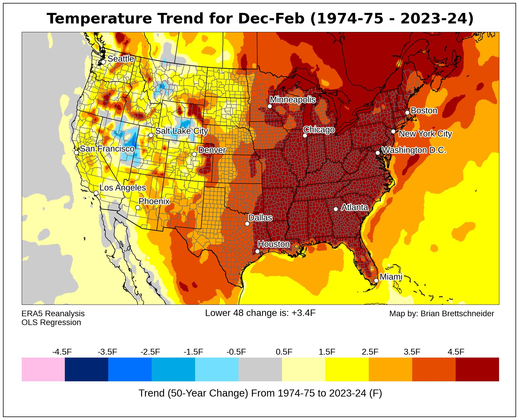
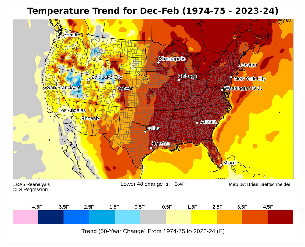
As usual you aren't addressing the issue. The station network has shifted north and west to higher and colder locations. Whether you acknowledge or not, the facts are clear from your station list. Even if station locations weren't shifting. Your analysis method of simply averaging station data skews the results. Stations can differ for a variety of reasons: sun exposure, degree of urbanization, vegetation, terrain slopes, etc. In any climate analysis of weather station data, differences between stations needs to be accounted for to remove station mix effects. You aren't doing it, so you are getting the wrong answer. The elevated group is a good example of the bias you are building in. I have data for 5 of the 7 stations. The other 2 only started in 2014 so don't have a big influence. Below is a plot showing linear temperature trends at the 5 individual stations and the linear trend for the 5-station average. Easy to see that simply averaging the raw data for these 5 stations biases the result. The 2 older stations, Glenmoore and Honey Brook, are warmer than the newer stations, Coatesville 2W, East Nantmeal and KMQS. This can be seen by comparing periods when one or more old and new stations are both in operation. All 5 stations have warming trends, with the most rapid warming in the three newer stations, which are warming as fast or faster than NOAA. Yet because they are cooler than the older stations, the 3 new stations cool the 5-station average when they start operation and enter the dataset. As a result the trend-line of the average of the 5 stations is completely flat. Despite the fact that temperatures are increasing at every single station. The relatively flat lines or lack of warming that you are getting is merely an artifact of the analysis method and doesn't reflect the underlying data. You aren't producing any evidence about Chester County's climate, NOAA, or the Philadelphia Airport. Instead you showing how to introduce bias in the analysis of weather station data, i.e., how not to analyze data.

-

Report: Another Year of Record Heat for the Oceans
Stormchaserchuck1 replied to donsutherland1's topic in Climate Change
Models suggest a strong -PNA (Aleutian High) for the next 10 days, so the warm weather there should continue.. -
How many panels do you have? I moved into a house with panels and I love it. I don’t get that much production but I’m almost certainly on a smaller lot.
-

Report: Another Year of Record Heat for the Oceans
GaWx replied to donsutherland1's topic in Climate Change
I’ve been following the Key West (KW) buoy data closely again recently to see how it is comparing to last year. Keep in mind that this buoy’s water temp is legit since it’s over deep water unlike the buoys over shallow FL Bay/just S of the S tip of FL. During 5/15-18/24, KW water averaged an insanely warm 30.5C! That was warmer than 5/15-17/23, which was “only” 29.1C. And then today (5/19), the KW avg rose to 31.0C! Last year around this date, KW started warming significantly and was up to 30.5C on 5/19/23. It didn’t fall back to that level til late August. The peak was on 8/10/23, when the avg was ~33.5C and one reading just touched 34.0C/93.2F!! There is a coral reef in this deep water near and I believe just S of the Keys chain. It suffered severe, extensive, and very longlasting bleaching much of last summer. I’ll be closely following this again this summer. If the most recent water temps are any indication, it isn’t looking encouraging. In addition to a significant increase in the warmth of the planet overall and more specifically in the N Atlantic Ocean in 2023 vs 2022, the Keys and nearby had a lengthy dry/sunny spell during July-early Aug, which exasperated the ocean heat. Will it be as bad there this summer? Key West latest buoy data: https://www.ndbc.noaa.gov/station_page.php?station=kywf1 2023 KW buoy data: https://www.ndbc.noaa.gov/view_text_file.php?filename=kywf1h2023.txt.gz&dir=data/historical/stdmet/