All Activity
- Past hour
-

2026-2027 Super El Nino
bluewave replied to Stormchaserchuck1's topic in Weather Forecasting and Discussion
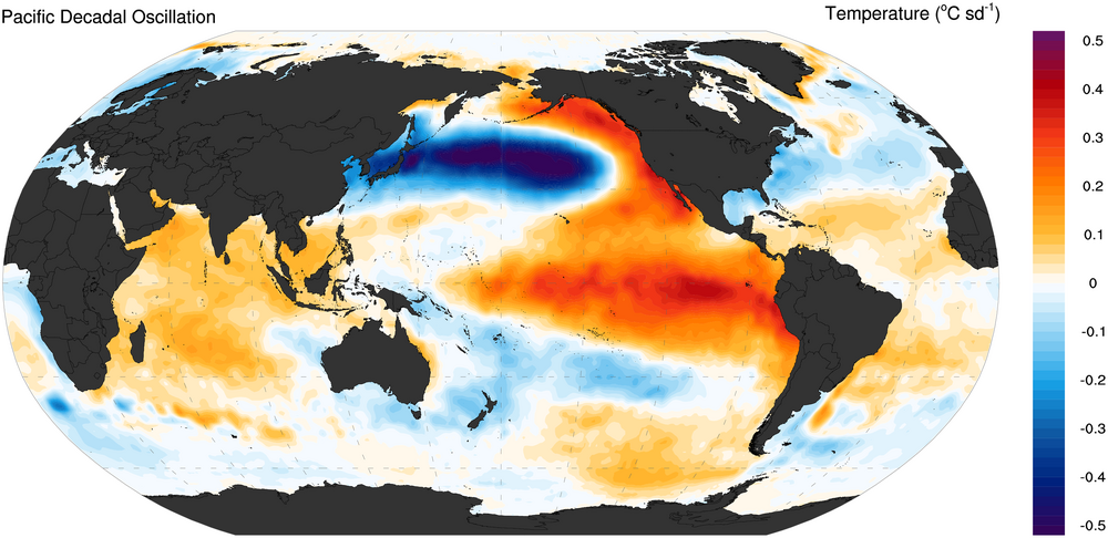
The extensive ridge driving the warm pool from east of Japan to the north of Hawaii is more of a 2nd EOF -PDO type pattern. This is why most of the analog dates for early July are La Niña years. You would want to see a deep trough set up from Japan to north of Hawaii heading into next winter to turn the PDO more positive.
-
Sun is out with a nice cool breeze...it's really comfortable out
-
1.23" in Leesburg? Feels like the rain event of the month so far, although admittely I haven't been around much but the yard looks mid summer parched.
-
Ended up with. 50 no complaints here
-
Used to spend a couple weeks up near Petoskey and Charlevoix as well every season. Great golf country.
-
There is no drought west of the Alleghanies. In addition to the lush foliage everywhere, was out on DCL twice last week and the lake appears full, even fuller than it was in the early spring. You can see the effects of the drought clearly as close as Hancock, the landscape almost abruptly turns brown past Sideling Hill.
-
.58" total last 2 days. Not bad. The first 21 days of June produced a glorious .09"..
-
Is that blob in jersey gonna make it
-

2026-2027 Super El Nino
frontranger8 replied to Stormchaserchuck1's topic in Weather Forecasting and Discussion
I believe the biggest factor for PDO calculations is that pool of water south of the Aleutians and to the north/northwest of Hawaii. -

Central PA Summer 2026 Discussion/Obs Thread
Itstrainingtime replied to Voyager's topic in Upstate New York/Pennsylvania
Wunderground stations near you would support that, a lot of them around .3" give or take. Interestingly, the stations down here recorded a bit less despite being further south. I finished with .21" at home so your area was a nice little jack today. -
https://x.com/SCweather_wx/status/2069485638059987262 Mitch West @SCweather_wx Ridge rider ring of fire pattern looking likely at the end of June into early July. This is by far one of the most interesting weather patterns we get during the Summer. Clusters of severe storms can ride down the side of the ridge. They can travel VERY long distances at times. We will watch to see how this unfolds in the coming days.
-
Occasional Thoughts on Climate Change
frontranger8 replied to donsutherland1's topic in Climate Change
Is the 33 record breakers for stations with 80+ year histories all-time records or monthly records? -
Translation: it'll still be very humid but the temp will be 90 instead of 100.
-

Wet late Monday 6/22 or another Fizzle?
BlizzardNole replied to Weather Will's topic in Mid Atlantic
Just 0.23 for today and it looks to be done. Pretty disappointing given expectations -
To each their own but meh. Besides the fresh seafood, I can do everything else right here locally on the shorelines of good ole Lake Michigan June-September. Wisconsin/Michigan/Indiana shores to be exact, IL beaches suck.
-
As if the sagamore wasnt already a huge bitch to drive through..what a nightmare
-
nothing beats a beach nap under a cabana with a light ocean breeze.
-
Spring break or bust
-
I love Florida (in February).
-

E PA/NJ/DE Summer 2026 Obs/Discussion
RedSky replied to PhiEaglesfan712's topic in Philadelphia Region
1.10" -
2026-2027 Super El Nino
bluewave replied to Stormchaserchuck1's topic in Weather Forecasting and Discussion
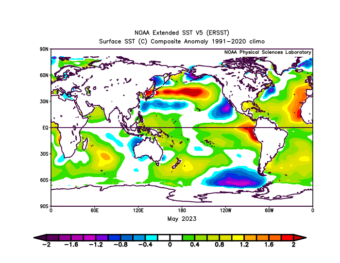
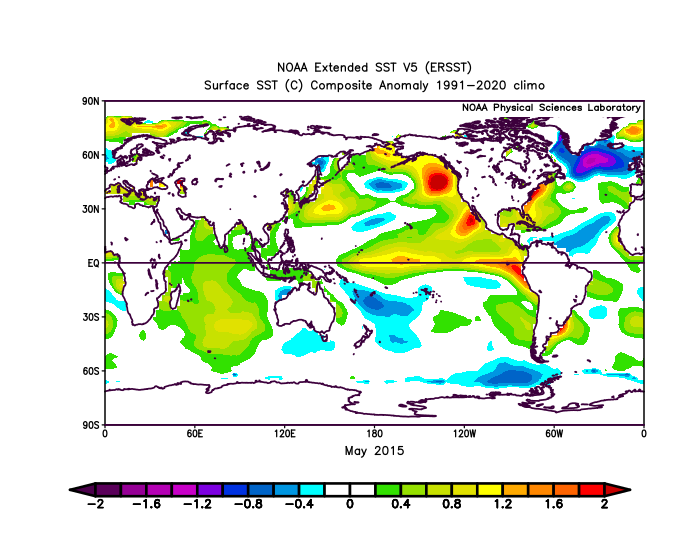
May 2026 was a little cooler than May 2023 around Japan. But much warmer than 2015 and 1997. This relationship is reflected in the PDO values for the month of May. Plus the area off the Baja was much warmer than 2023. https://www.ncei.noaa.gov/pub/data/cmb/ersst/v5/v6/index/ersst.v6.pdo.dat May 2026 PDO -1.60 May 2023 PDO -2.46 May 2015 PDO +0.40 and +1.65 by July May 1997 PDO +1.29 and +2.35 by June Traditional strong +PDO pattern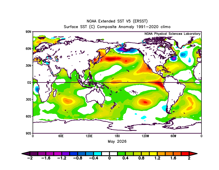

-

Late May/June 2026 Medium/Long Range
EastCoast NPZ replied to JenkinsJinkies's topic in Mid Atlantic
Of course it does, just in time for me to head out west. -

Central PA Summer 2026 Discussion/Obs Thread
Mount Joy Snowman replied to Voyager's topic in Upstate New York/Pennsylvania
I was thinking the same as I stare out the window here into the capital city. There was a sharp cutoff just southeast of Harrisburg, which was actually modeled very well by the Meso's this morning. I think I'm going to be up around a third of an inch back home. - Today
-
 Baum changed their profile photo
 -
Spent 15 straight summers on the beach in longboat key, Fla in June/July. Never encountered any bug issues on the shore. Even got a daily sea breeze. Beautiful cumulo nimbus towers with lightning, rainbows, and fire orange tops. Every now and then a tropical storm to cool it down and bring in some good wave action. Big calls; was lobster or shrimp for dinner? What day do I go deep sea fishing? SPF 6 or 15 on the lotion? Corona or a local beer for sitting on the beach. It sucked alright. All that said, looks like we may get some real summer before the 4th. On cue.
-
Wow. Nice. Just Under 0.15 here