All Activity
- Past hour
-
0.7" of snow imby yesterday. 1"+ inland. Next event is showing some mix come Thurs.
-
When models killed our 2 feet of snow in favor of 8-12 with 4” of sleet this is why I kept smiling and telling people that it made me even more excited. I know big snow number is something we all love but the 2017 sleet storm converted me and I knew what was possible. This storm delivered beyond my imagination. Cars will be locked in glaciers for weeks. The world is white and frozen. I love this so much lol.
-
That KHKY reading is bunk. It must be due to urban heat island of concrete around the airport. I'm a couple of miles from the airport (line of sight), and my Davis Vantage Vue registered 8.2 as our low this morning, around the time this was posted.
-

WxUSAF's weak ass frontal passage thing.
NorthArlington101 replied to dailylurker's topic in Mid Atlantic
This is gonna be a weak little system. Would be nice to get a consensus for a 1" strip somewhere but it may never happen. Might just need to wait til the day of and see. -

February 2026 Medium/ Long Range Discussion: Buckle Up!
Terpeast replied to Weather Will's topic in Mid Atlantic
Strat warming is on the atlantic side, so that should knock the AO back down. Can already see hints of it doing that in the dashed mean line starting to turn downwards right at the end. -
I’m in the cold pool of air to your east/northeast. My low was -3 currently it’s +6. It’s a rare occurrence where my temps get lower than yours.
-
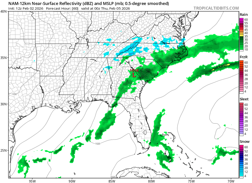
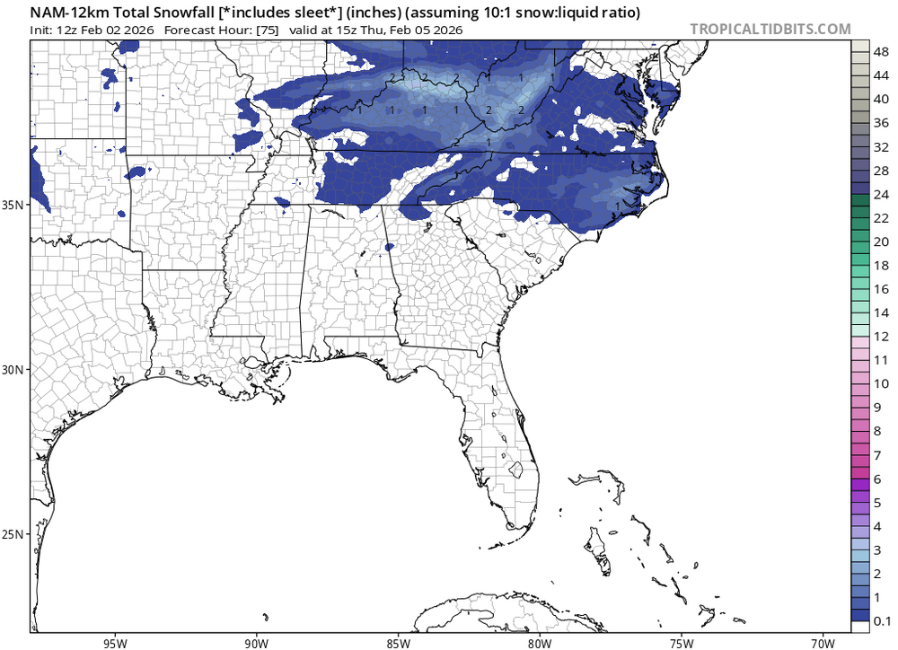
Someone's about to get NAM'ed start the thread! At this point a lot of us are playing with house money so let it Ride!! Also, FV3 is not quite cold enough but does have some heavier banding type precip building in the foothills. If the run were to continue I would think some eastern folks might get a little interesting!i
-
It’s going to torch today. We have gone from 12 to 28 already, the last of Saturdays nightmare might be gone by this afternoon
-

Pittsburgh/Western PA WINTER ‘25/‘26
TheClimateChanger replied to Burghblizz's topic in Upstate New York/Pennsylvania
Quite a wide variance in temperature on the car thermometer this morning. Saw as low as -8F at one point. Zelienople Airport had a low of about -15F. National Weather Service -
This is awesome! I don't remember the last time it was this easy to walk on a snowpack around here.
-

2025-2026 Fall/Winter Mountain Thread
Maggie Valley Steve replied to Buckethead's topic in Southeastern States
For what it's worth, the 12Z 3km NAM suggests an inch of snow tomorrow night into early Wednesday here in Western Haywood County. Clouds are moving in currently over the Valley. It would be nice to get above freezing today. -

February 2026 Medium/ Long Range Discussion: Buckle Up!
frd replied to Weather Will's topic in Mid Atlantic
The - AO on the rise. Have to see late month's reaction to the strat. Its been a crazy ride so far. -

Jan 30th-February 1st 2026 Arctic Blast/ULL Snow OBS Thread.
Jed33 replied to John1122's topic in Tennessee Valley
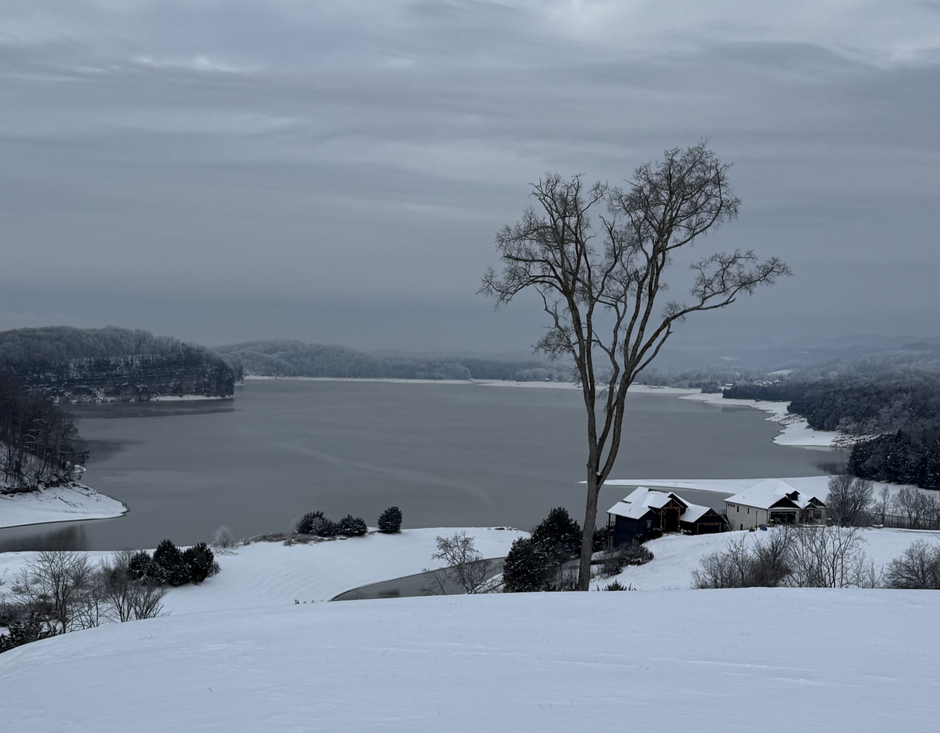
This was the view from my neighbor’s house earlier this morning. Overlooking Cherokee Lake. For reference I’m at the corner of Hamblen, Hawkins, and Grainger Co. Ice is beginning to form in spots on the lake. I’ve only seen that 1 or 2 times since we’ve lived here. An impressive airmass for sure!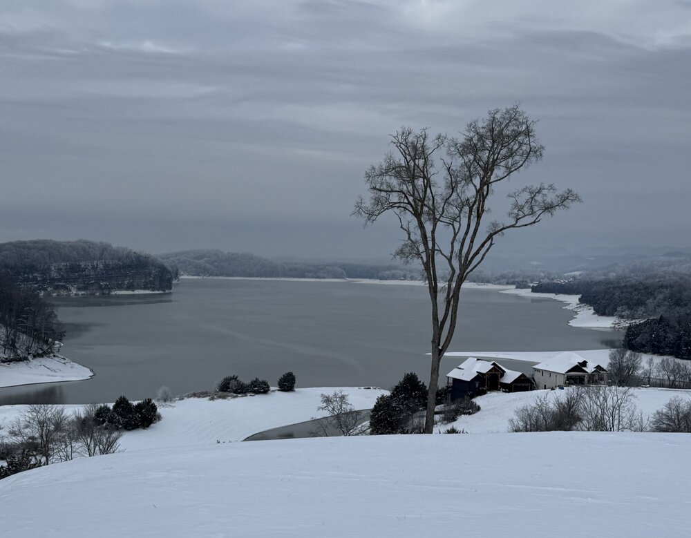
-
(002).thumb.png.6e3d9d46bca5fe41aab7a74871dd8af8.png)
Central PA Winter 25/26 Discussion and Obs
ChescoWx replied to MAG5035's topic in Upstate New York/Pennsylvania
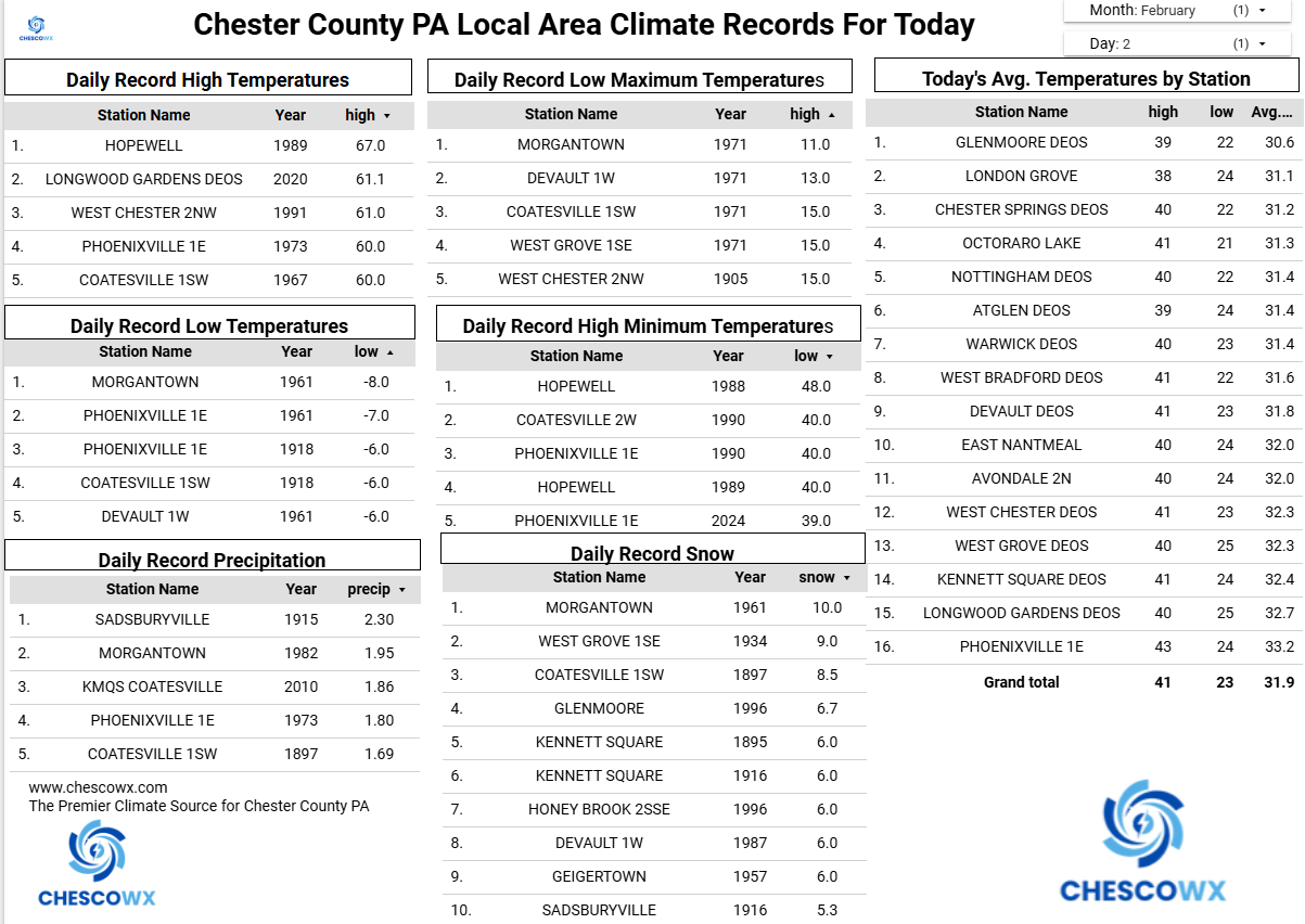
One of our mildest morning lows in over 10 days here in Chester County with all stations remaining in the low to mid-teens. Today and tomorrow look like our mildest days over the next week. High temperatures today will be in the upper 20’s, and some spots tomorrow have a chance to reach freezing or above for the first time in 11 days. We turn colder again to close out the work week and will turn significantly colder again by the weekend with temperatures remaining in the teens for highs. We have a couple of minor snow chances this week - the first on Tuesday night and another on Friday.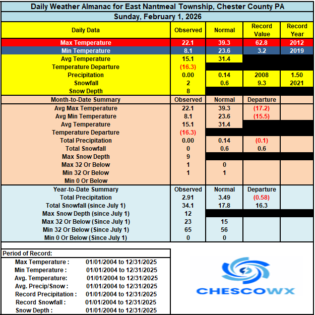

-
E PA/NJ/DE Winter 2025-26 Obs/Discussion
ChescoWx replied to LVblizzard's topic in Philadelphia Region
One of our mildest morning lows in over 10 days here in Chester County with all stations remaining in the low to mid-teens. Today and tomorrow look like our mildest days over the next week. High temperatures today will be in the upper 20’s, and some spots tomorrow have a chance to reach freezing or above for the first time in 11 days. We turn colder again to close out the work week and will turn significantly colder again by the weekend with temperatures remaining in the teens for highs. We have a couple of minor snow chances this week - the first on Tuesday night and another on Friday.
-
Definitely. We're on like a A-/B+ through Feb 2nd. Even if we get skunked from here on out the lowest i could give it is like a C/C+ even with zero snow but the chances of that happening are close to nil. We've had two warning events and very solid snowpack with a lot of cold but it hasn't been phenomenal like 95-96 or 10-11. Solid first half. Yeah it's Feb 2. BDR right now is around climo, BDL is about 15" below climo (for the whole winter). There's plenty of winter to go. We are at the halfway point climo-wise. Normal climo snowfall is at/around 50% through February 2nd. BDL is normally at 27.5 of 51.7 and is currently at 35.8, BDR is 15.8 of 33.6 and is currently at 33.2. BDR is doing extremely well through the date around 210% normal.
-
 What’s your lowest recorded temperature up there?
 -
 Widespread single digits this morning
 -
Wadesboro plummeted to 3° this morning.
-
some forecasters were mentioning it would fall below 0 in this current extended arctic outbreak - this next one over the weekend will last only a couple days so odds of Central Park going below zero as of today are not favorable IMO -suburban locations have a better chance - plus where is the thermometer they use located and how much snow cover is left there ?
-
and the 3k is worse lol (isnt it always)?
-
You guys have no idea how happy I am that my kids got to experience something I have never experienced myself. We went snow tubing on a local field that was at least 6 acres. Walking on the clean snowpack without our feet making footprints was wild! I'm 280lbs and I was literally running and my feet did not create footprints! And the tubing on the slickest surface ever? Kids loved it. The tube went fast and far. They could even slide down the hill on their butts! They laughed and had a good time. It is an awesome experience. If we don't get another inch, the last storm will create lasting memories which is good for any kid.
-
Siler City and Lumberton got down to at least 0° this morning
-

WxUSAF's weak ass frontal passage thing.
somecallmetim replied to dailylurker's topic in Mid Atlantic
Looks like we got de-NAMmed. -
What's the over/under that Central Park goes below 0 this weekend?