All Activity
- Past hour
-
-
Looked like a direct hit on Reading
-
Just missed by a cell passing to the north, and then a cell passed to my south and is currently blowing up to the SE. Can't win.
-
90/77 down here, nice comfortable heat index of 104.
-
1.41" rain here today, which bumps us to 4.03 for June.
-
Nice 4k cape bullseye for me https://twitter.com/miketfox5/status/2065198212349063610?s=46&t=JYOHM881b6groqc0-RqtxA
-
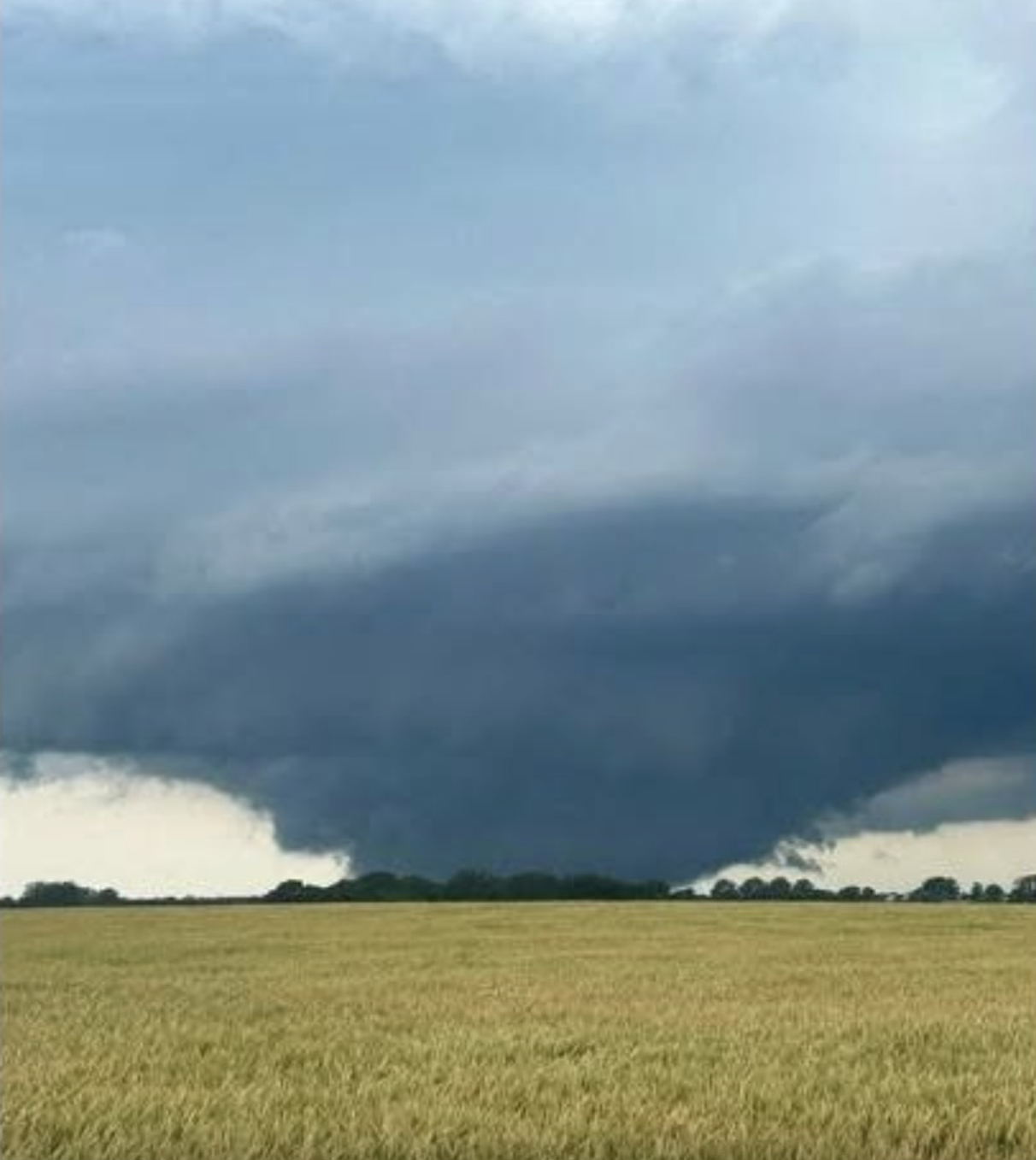
Giant tornado near Streator IL per Colin Davis. Environment near those two supercells in central IL is extreme, STP of 10, SCP of 40, 3000+ MLCAPE and 500+ ESRH.
-
tornado debris signature by Streator IL
-
I don’t know, but the SW corner of Michigan might still be in play for a couple tornadoes. Higher dewpoints have finally surged north. Maybe the dying crapvection boosted the moisture but 2000 j/kg should be enough if it maintains.
-

Central PA Summer 2026 Discussion/Obs Thread
Voyager replied to Voyager's topic in Upstate New York/Pennsylvania
Looks like a nice line of storms out west per radar. Their arrival after 8pm might steal some of their thunder (pun intended) though. -
Watching these storms evaporate into thin 95 / 75 air on approach is simply amazing. Lots of wind though, of course.
-

Central PA Summer 2026 Discussion/Obs Thread
canderson replied to Voyager's topic in Upstate New York/Pennsylvania
96 at the house. Car reads 98 here in camp hill. Had a 2 hour outdoor event at 3. I’m wiped out. It is nasty out. -

2026 Mid-Atlantic Severe Storm General Discussion
batmanbrad replied to Kmlwx's topic in Mid Atlantic
I can see some gust front/outflow boundaries pushing out ahead of that line -
The cell just north of Waldo IL might be next to go if it can stave off any crap-vection.
-
Another discussion, likely a watch is coming for some: https://www.spc.noaa.gov/products/md/md1096.html
-
95 in Kearny, nj still baking!
-
Yaphank got blasted. 2 for 2 with the thunderstorms this year. My highly sheltered PWS saw gusts of 35+ mph, the highest since Isaias. Probably 65-70 mph gusts in reality.
-
Central PA Summer 2026 Discussion/Obs Thread
canderson replied to Voyager's topic in Upstate New York/Pennsylvania
Sorry just got back here. I meant chances - it’ll storm but I don’t see guest severe with hail. Tomorrow is a better chance. -
I wonder if the cell merger well help steer it right at Kankakee, yet again. The track is so similar to the one in March. It’s isolated enough to produce multiple times.
-
https://x.com/Kentucky_WX/status/2065192083921543679?s=20
-

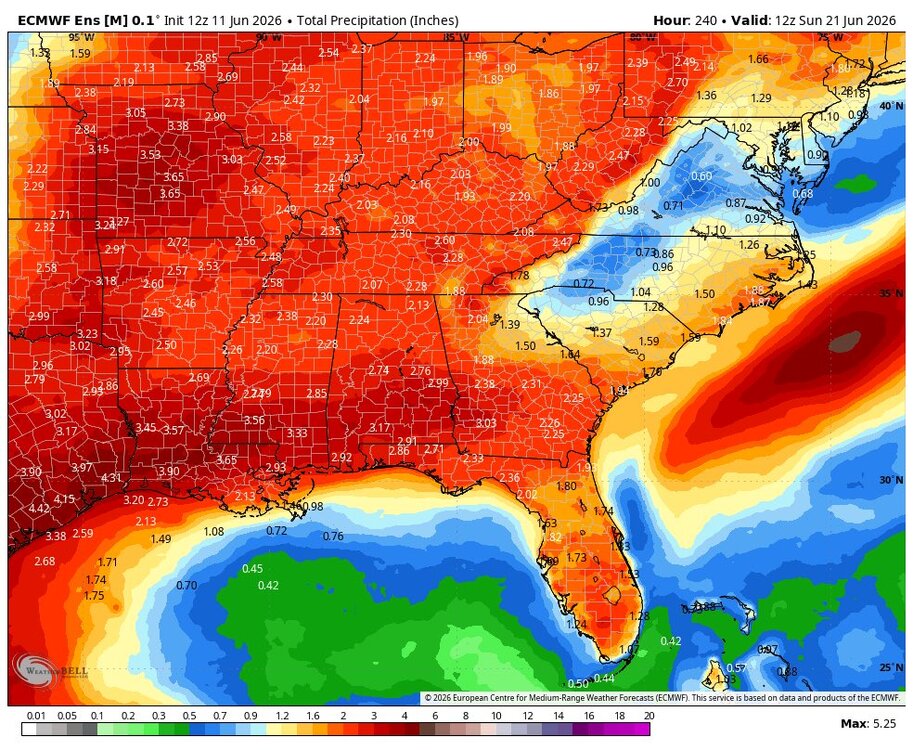
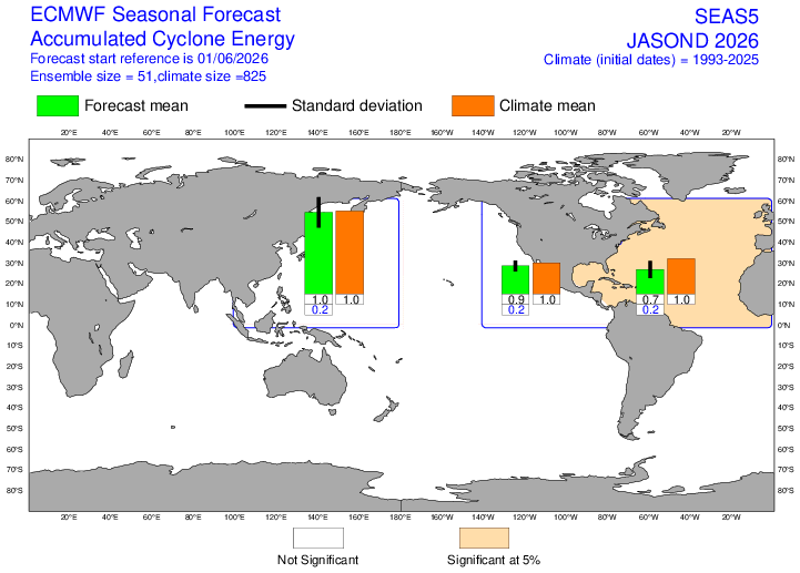
2026-2027 Super El Nino
mitchnick replied to Stormchaserchuck1's topic in Weather Forecasting and Discussion
This month's Euro seasonal doesn't look that impressed for hurricanes/tropical systems beyond climo, with only the eastern Pacific showing a slightly higher frequency while all areas, except western Pacific, within the forecast down in the intensity (ACE) department.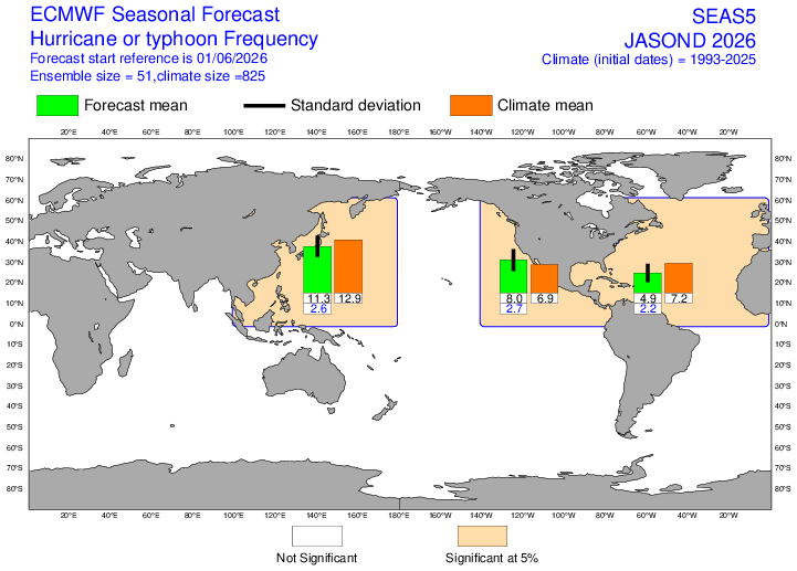
-
Anything coming out from the one that just passed over Toluca?
-
Looks like a couple more spinups possible on that line
-
insane pics coming out of that cell... will be interesting to see how it reacts to these mergers


.thumb.jpg.ad3a2e31d30aff035044689b311a0540.jpg)