mitchnick
-
Posts
26,304 -
Joined
About mitchnick

-
Cfs2 has been liking this look for August and September fwiw. Here's August: https://www.tropicaltidbits.com/analysis/models/?model=cfs-mon®ion=us&pkg=z500a&runtime=2025071806&fh=1 https://www.tropicaltidbits.com/analysis/models/?model=cfs-mon®ion=us&pkg=T2ma&runtime=2025071806&fh=1
-
Who referenced Nao or winter? I just pointed out the current solar spike was a short term spike. No more, no less. The irresistible impulse of you and Bluewave to turn everything negative for posters who enjoy cold or snow is strange to say the least. Actually, it's likely much worse than strange.
-
Transient as it breaks the following week.

-
Negative PDO may have peaked with notable cooling around Japan over the past 15 days.
.png.2ab49958f434b3def68398dc8617d2ef.png)
-
Looks much more temporary when you look at the graphs at the top and bottom of this page. https://solen.info/solar/index.html
-
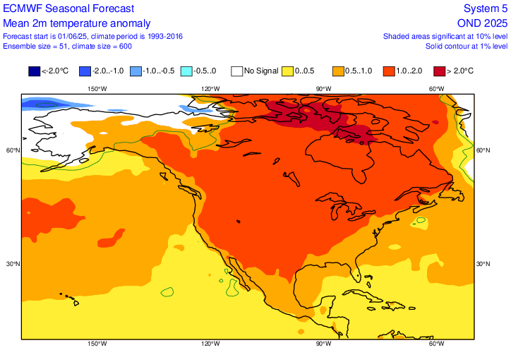
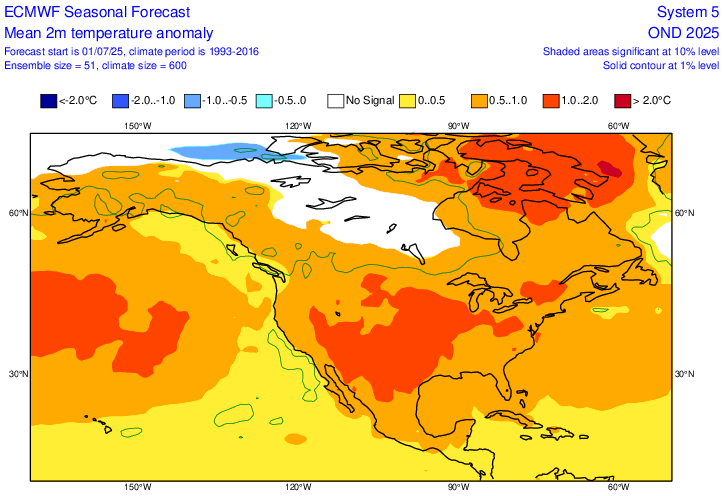
I hadn't posted this, but meant to relating to the trend issue. Top pic is the Euro seasonal June temp forecast for OND and the bottom is July's forecast for same period. I know 2 months aren't a trend, but again, it's moving toward the Cansip with a non-furnace Canada into the Conus. Plus, AN areas aren't going wild.
-
That's why I like the Cansips...it can be used to argue both sides pretty convincingly! But seriously, as I said in my last post, I think seasonal model trends for a future season, and not a 1 month forecast, are worth following.
-
Seasonal models by definition are intended for periods beyond 1 month, which is why I consider weeklies as being more accurate for 1 month, though flawed too as we know. But that's why I look at forecast trends in the seasonal models as a whole as a better method than taking the forecasts at face value.
-
Agreed, but you know as well as I do you'd never would have posted first! Lol
-
I didn't want to say it, but thought the same thing.
-
Ok, we're back to the 1 particular month issue again, so you'd have to do some kind of compilation of comparing 1 month forecasts verifications. But I've always considered the Cansips a seasonal model even though it forecast period begins at 1 month. For purposes of this discussion, I'm looking for forecast trends in modeling for 6 months out. And as I said, Cfs2 and Euro seasonal show similar trends in areas of at or BN as the Cansips.
-
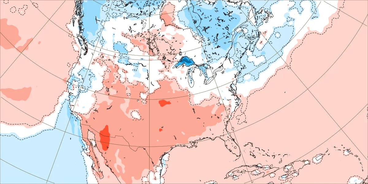
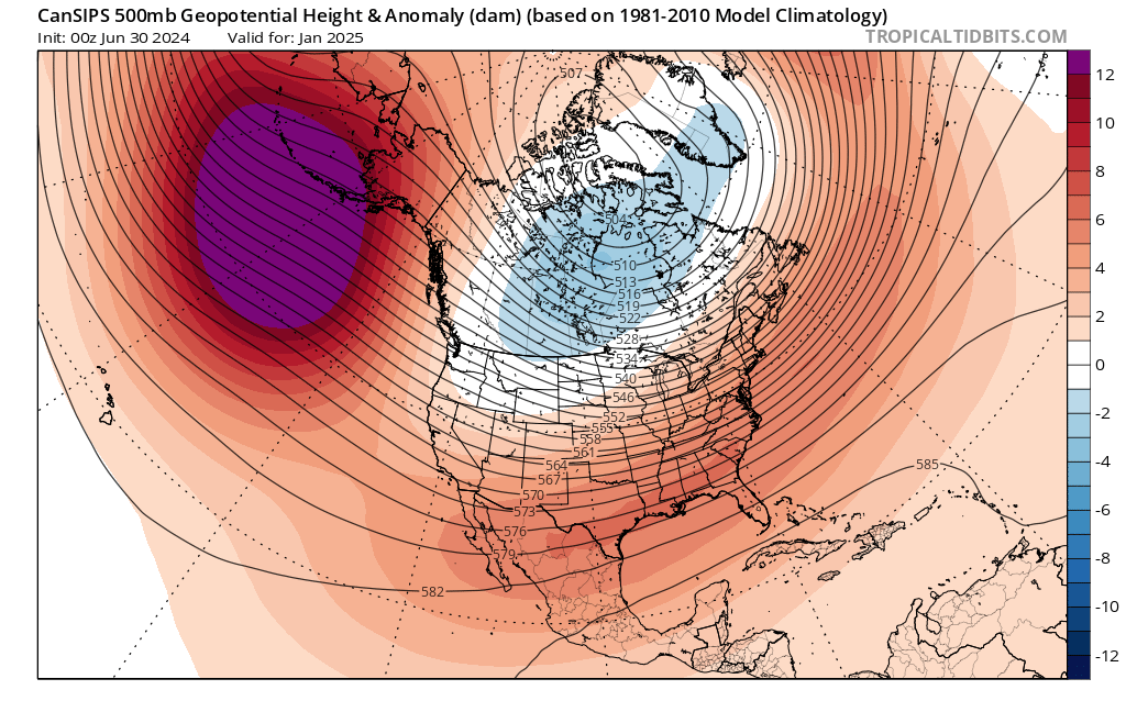
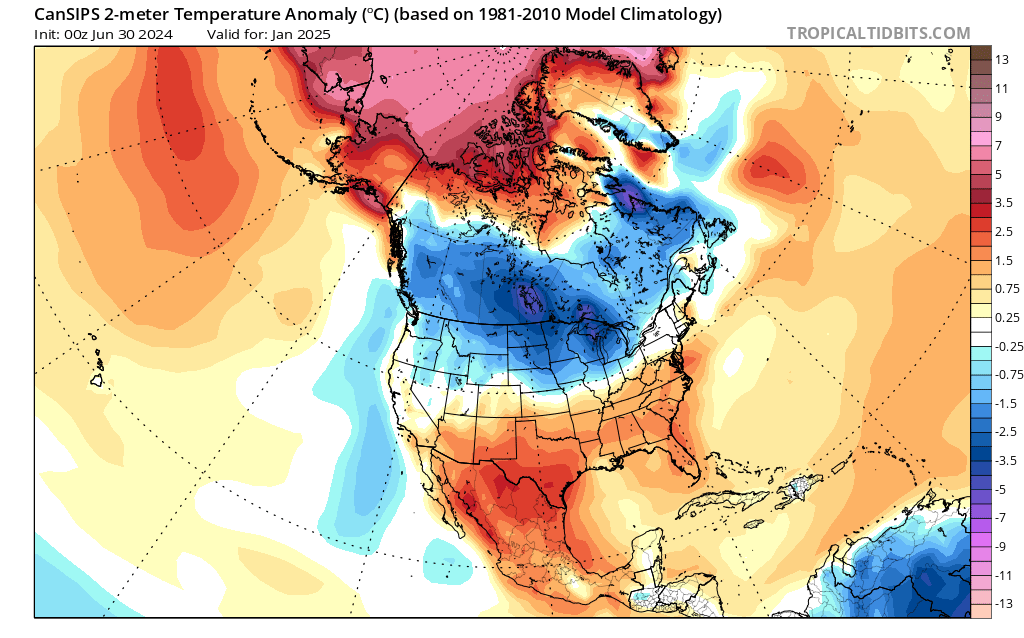
Cansips is not perfect, and I never said it was. But your statement it's biased in one direction doesn't always hold true. Ask the central, southern, and eastern areas of the conus about 1/25. Top map Cansips 500mb 1/25 forecast from 7/24 Middle map 2m 1/25 forecast from 7/24 Bottom map actual 1000mb map from 1/25 I'd like to know how many other seasonal models were showing any BN temps in January from their 7/24 forecast, other the Pac NW.


-
But we can always pick out model errors with every model, short, medium, and/or long range. Cansips had a "relatively" decent forecast last winter and now the ever warm Cfs2 and arguably the latest Euro seasonal are looking similar to its forecast for this winter. They could all be right or wrong, but to pick out any one forecast from any one of them and say "it was wrong here, so I don't trust it" is tantamount to saying all modeling is useless. If that's the way you feel, that's fine because sometimes they are, but to cherry pick one forecast doesn't support your case one iota it's going to be wrong.
-
Remember. The Euro is giving us 3 month averages on each forecast map, so keep that in mind when looking at the forecasts. The trend is what you need to consider as well as actual numbers.
-
Remember. The Euro is giving us 3 month averages on each forecast map, so keep that in mind when looking at the forecasts. The trend is what you need to consider as well as actual numbers.