All Activity
- Past hour
-
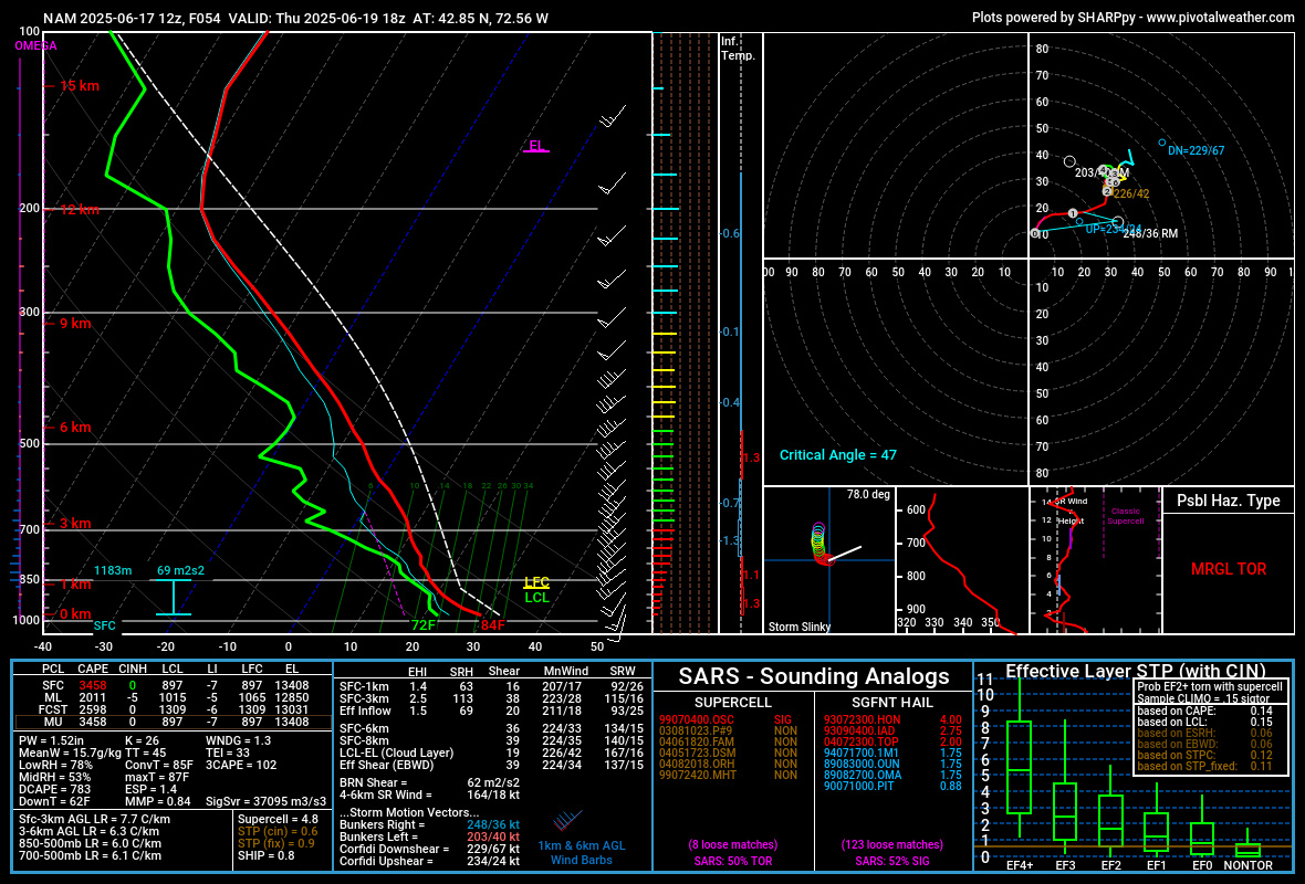
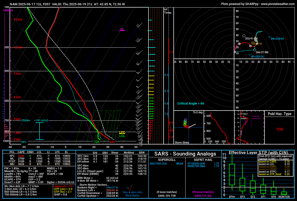
Thursday's severe threat seems decent especially near/west of I-91. Mid-level lapse rates are fairly steep plus decent low and deep layer shear.
-
Hot spot. Over the last 20 years, the BDL average for year's hottest is 98.2. 15 years reached 97 or hotter, though only 5 set a year's hottest before July 1.
-
Summer softball starts tomorrow. Need some sun to dry out soggy infields
-

New England 2025 Warm Season Banter
backedgeapproaching replied to bristolri_wx's topic in New England
Yea, I saw that..oof. I took mine apart as much as I could and did a bleach cleaning and let it dry. I think every window AC prob has some type of issue with water and some mold, but yea looks like a design flaw. -
I never lost power at my home in little ferry. It surged all night but never went out. Was odd being one of the few houses in the area with full power...and A/C!
-
Let's break the power grid. 105+
-
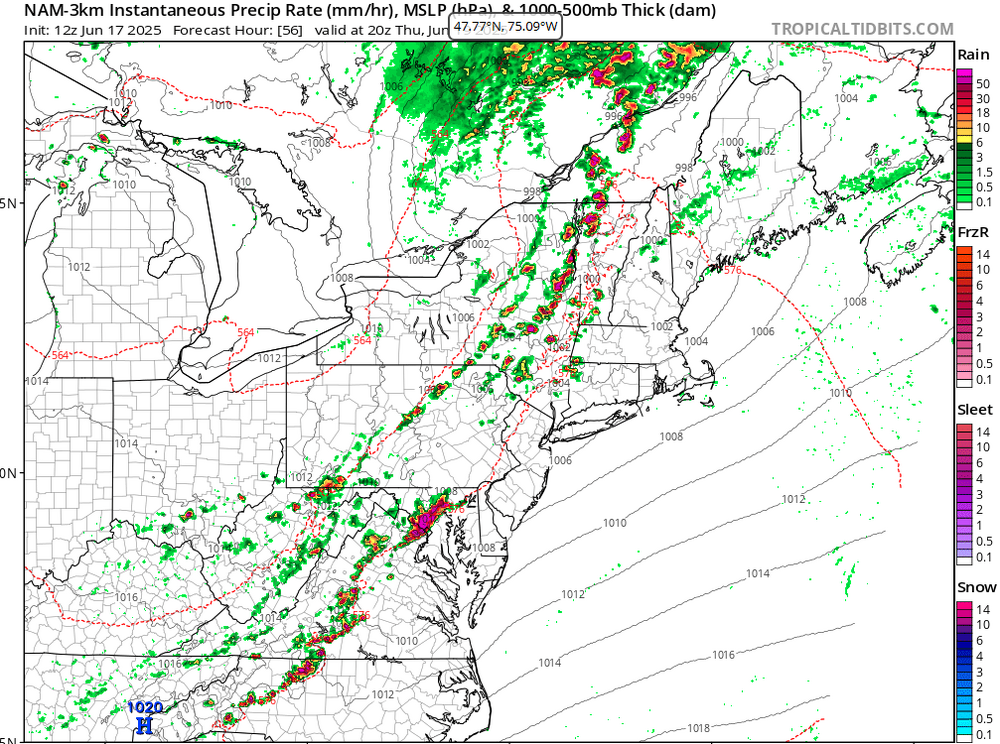
Much of central PA is now under a moderate risk of excessive rainfall today. CTP highlighting the area for "Dangerous Flooding."
-
We live on an island surrounded by water…
-
Yeah I’m selling on 104-106. 100 though seems possible
-
This looks fun for Thursday....
-
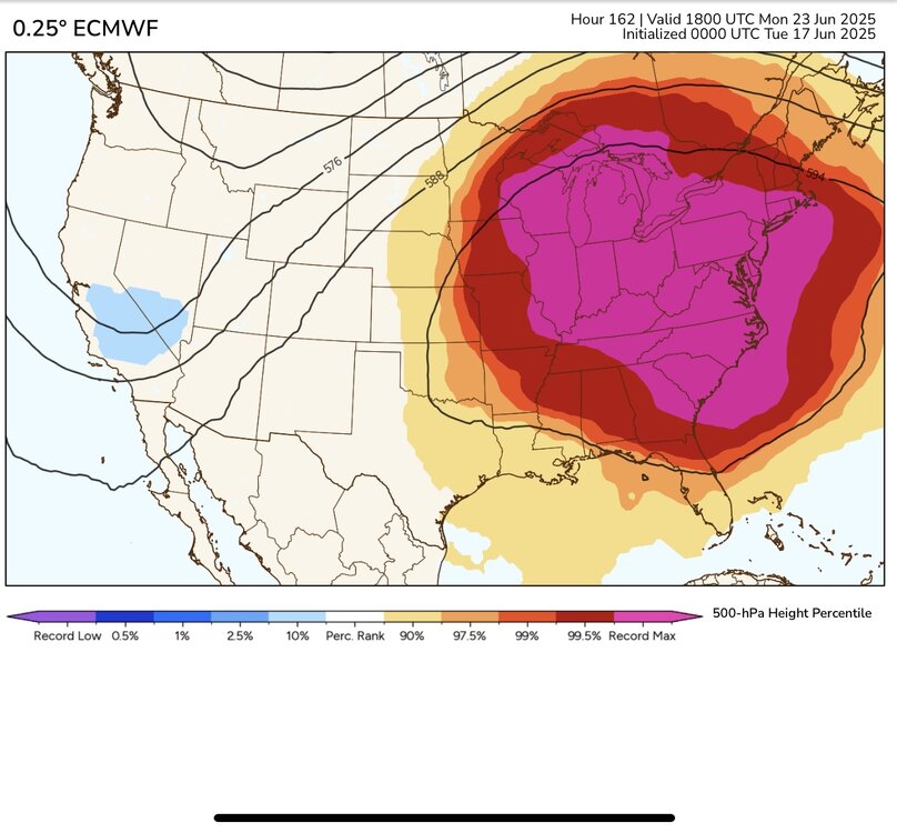
We just set the all-time 500mb height last June at 599 DM. So getting a ridge nearly this strong only a year later is pretty extreme. Several spots around the region made it to 100°. This time around the models are forecasting 850mb temperatures which will be several degrees higher around 22C to 23C. So there is a good chance that the usual warm spots from Central NJ to interior Queens will see 100° or higher heat next week with how unusually well the ensembles agree. Newark recently set their June all-time high of 103° back in 2021 which could be challenged. LGA recorded their 2nd highest June high temperature at 100°. Their all-time June high is 101° set in 2017.
-
lets frickin roast
-

E PA/NJ/DE Summer 2025 Obs/Discussion
LVblizzard replied to Hurricane Agnes's topic in Philadelphia Region
Slight risk for Thursday…of course I won’t be around, instead I’ll be in Denver baking in 100 degree heat. I also managed to pick the deadest 3 day period for storms in Denver since storm season began, so no chasing like I was looking forward to. Oh well. -
Euro ran way too high last year at range. GFS seems to have a high bias in the metro areas too.
-
While a bit warmer out than yesterday, 71. Just got myself a nice cup of tea and popped my slippers on. Also I know there are others on here with PWS in their yards. I have had my station reporting to Weather Underground for sometime now. But I finally was able to get my reporting set up for PWSWeather. It does not activate right away as it does quality checks of your station before making it active. But I have mine up and reporting now. You can find the link below in my signature. They have a handy App also for on the go.
-
Yeah, that is why I was confused a bit. I never noticed that either.
-
Pouring in Greenfield at the moment.
-
65/63 small droplet sheet rain nonstop since 11pm last night. Far cry from the 20% chance of showers that the NWS forecast was showing as late as 5pm yesterday.
-
all time june records are possible
-
Managed to get .24" from the scattered storms yesterday and early this morning, plenty for the garden.
-
Damn NAM...

-
I haven't watered at all this year. Not even my planting beds. And I'm cutting my grass every 5 days.
-
That MCV looks like a frickin' landcane on the 12Z 3K NAM. Too bad it can't be coming through 3-4 hours later.
-
keep dreaming snow bunnies
-

2025-2026 ENSO
PhiEaglesfan712 replied to 40/70 Benchmark's topic in Weather Forecasting and Discussion
Is this what happened on 7/22/2011 when EWR got to 108?


.thumb.png.4150b06c63a21f61052e47a612bf1818.png)