All Activity
- Past hour
-

Augdewst 2026: Summer's Last Stand
weatherwiz replied to Prismshine Productions's topic in New England
Looks like Hawaii dodging a bullet with Two-C -
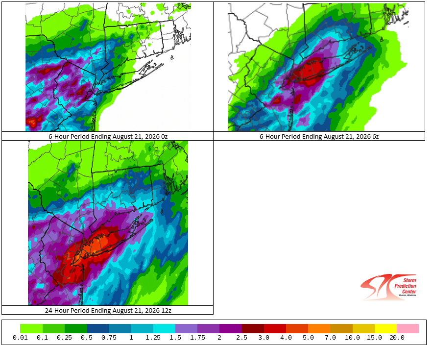
The August 20, 2026 12z HREF:
-

E PA/NJ/DE Summer 2026 Obs/Discussion
RedSky replied to PhiEaglesfan712's topic in Philadelphia Region
Drought buster incoming -
Augdewst 2026: Summer's Last Stand
weatherwiz replied to Prismshine Productions's topic in New England
Very tough forecast. Definitely better potential for more in the way of consistent rain eastern CT and points east, particularly on Saturday. Sunday I don't think is a rain all day but there could be some room for some strong storms and downpours in the afternoon if we destabilize enough. Saturday could be like EOR type ordeal and Sunday WOR -

Augdewst 2026: Summer's Last Stand
Chrisrotary12 replied to Prismshine Productions's topic in New England
We’re #1. We’re #1. We’re #1! -
Crapvection around now
-

Augdewst 2026: Summer's Last Stand
Ginx snewx replied to Prismshine Productions's topic in New England
Shit weather incoming. Damn it. Hopefully doesn't rain all weekend. -

2026-2027 Record-breaking El Nino
40/70 Benchmark replied to Stormchaserchuck1's topic in Weather Forecasting and Discussion
It seems to me like we are establishing a modest cool ENSO baseline of sorts due to the increased warmth pooling the western Pacific. however, for that same reason the frequency of powerful El Nino events is also increasing.....ie more frequent La Nina, but weaker...less frequent El Nino, but more powerful ones. -
A refresher on the way.
-
I've had lots of rain in Currituck NC the past few weeks. Mowed yesterday afternoon but ground still saturated. However, it doesn't take much for my particular location to stay wet for a long time since I'm only about 4 ft above sea level. Looking at another soaking the next 3 days.
-
hi-res baby canuck been having a summer
-
secret on our wonderful region very much out these days
-

2026-2027 Record-breaking El Nino
Maestrobjwa replied to Stormchaserchuck1's topic in Weather Forecasting and Discussion
And here I eas thinking we were going the opposite way with the perpetual nina we've had...I mean one double nina and one triple dip in the last 6 years has just been dumb, lol -
Agreed. Fantastic AFD. The team at LWX is top notch.
-
And Christmas 1965: 69hi Notice what happened later in the winter after the three Christmases we hit 69 or 70...lol Big blizzard! So maybe that'll be the tell this year...69-70 or above on Christmas day--we snow later 60 or below? No go...while I don't like warm Christmases I will happily take one in exchange!
-
Are you here on vacation? I live just outside of Estes Park, and Trail Ridge Road is really special. For an added experience, you can go up a one way road (Old Fall River Road) that exits at the Alpine Visitor Center at the top. You then take TRR back down. I have seen snow falling at the top in both July and August many times. Not much but enough to remind you just how high up you are.
-

Augdewst 2026: Summer's Last Stand
Brian5671 replied to Prismshine Productions's topic in New England
same ol pattern. Hoping it misses here...we are waterlogged -

E PA/NJ/DE Summer 2026 Obs/Discussion
Chadzachadam replied to PhiEaglesfan712's topic in Philadelphia Region
another case where strong storms are possible in the evening but we get some rain early in the day. wonder if we fail the same way as we have earlier this summer, with too much going on and not enough instability left by the time the storms are expected -

2026 Spring/Summer Mountain Thread
Maggie Valley Steve replied to Buckethead's topic in Southeastern States
Looks like an early taste of Fall will arrive this weekend extending into early next. My point and click forecast is showing low to mid 50's for morning lows! -
Lets see how the models do over the next 10 days precip wise. The mean average for MBY last Sunday was .5 inches, I received over 2in within 72 hours. To be honest, the Canuk and Baby Canuk did the best with last week and this week in the medium to long range. It has me around 1.5in thru 10 days while the others just a spittle. If it keeps up I'm riding it into March in mby lol
-

2026 Mid-Atlantic Severe Storm General Discussion
Eskimo Joe replied to Kmlwx's topic in Mid Atlantic
Given the tornado risk east of I-95, this is justified. I could see a tornado watch going up east of here.- 2,022 replies
-
- 2
-

-

-
- severe
- thunderstorms
- (and 7 more)
-
I think it's also possible to get too extreme in the other direction as far CC goes, and this isn't a slight at John..as I discussed last spring, I was actually guilty of that last winter and it ultimately served to tarnish what was an otherwise absolutely exemplary seasonal effort. It's crucial to find and maintain that balance between the synthesis of lessons learned to inform future efforts, while also appreciating that each individual season possesses important differences. I'm still trying to find my proverbial footing in that regard.
-
Spc has day 1 outlook a marginal risk out for south of i40 for west middle and east tn also for the majorityish of the Deep South for 5 percent hail in southwest tn nw Alabama north Mississippi and also 5 percent wind https://www.spc.noaa.gov/products/outlook/day1otlk.html .
-
No precipitation that was measurable this week. Still at 1" MTD for August. Drought remains at D1
-
I was surprised yesterday evening when my P&C forecast had 1-2 inches for tonight! Now it's a more typical quarter to half inch. Sun is coming out and it's a muggy 83/76. Hoping for a flush hit later but won't be surprised if it's NE Maryland pummeled again