All Activity
- Past hour
-

Winter 2025-26 Medium/Long Range Discussion
Baum replied to michsnowfreak's topic in Lakes/Ohio Valley
For sure. This week. -

February 2026 Medium/ Long Range Discussion: Buckle Up!
RevWarReenactor replied to Weather Will's topic in Mid Atlantic
The 6z GFS offers some hope. Tonights clipper is more north. Friday's clipped is more juiced with some places gettsing a few hours of light snow. VD looks like two potential's could be rain, could be congrats north carolina, but the potential is there. -

WxUSAF's weak ass frontal passage thing.
PrinceFrederickWx replied to dailylurker's topic in Mid Atlantic
He was a funny guy but hasn’t posted in many years. I remember in one of his posts before he disappeared he said he had cancer. -

Winter 2025-26 Medium/Long Range Discussion
A-L-E-K replied to michsnowfreak's topic in Lakes/Ohio Valley
zzzzzzzzz -
 Down to 0F here.
 -
Topped out at 34 here yesterday, currently @ 12F.
-

January 30th- Feb 1st ULL and coastal storm obs
WinstonSalemArlington replied to JoshM's topic in Southeastern States
-
-
 3 for the low, maybe a little roof shoveling small flat roof when we hit 30s later.
 -

Central PA Winter 25/26 Discussion and Obs
anotherman replied to MAG5035's topic in Upstate New York/Pennsylvania
Some mangled snowflakes in York. -

Richmond Metro/Hampton Roads Area Discussion
wasnow215 replied to RIC Airport's topic in Mid Atlantic
Pithy-not gonna cut it. Friday snow squaws better chance with clipper -

Is we back? February discussion thread
Damage In Tolland replied to mahk_webstah's topic in New England
Euro AIFS and GFSAI have major winter storm 13-14th. Gaining traction -
I'm no expert on the stratosphere, but it looks like it's about to split into two, which promotes more HL blocking?
-

Central PA Winter 25/26 Discussion and Obs
pawatch replied to MAG5035's topic in Upstate New York/Pennsylvania
When I went to bed it was 10 degrees. When I got up this morning it was 17 degrees. High of 30 yesterday, but it was pretty windy. Voyager you need a factory job. Where your in the warm. -
temp overperformed this morning in the city temps were predicted to go down in the upper teens..
-
It was the only time Central NJ finished a season with 80.8°of snow and Newark couldn’t make it to 50”. Snowfall Data for October 1, 2009 through April 30, 2010 Click column heading to sort ascending, click again to sort descending. WRIGHTSTOWN COOP 80.8 HAMMONTON 3.3 WSW CoCoRaHS 79.6 FRANKLIN TWP 2.7 W CoCoRaHS 79.0 TOMS RIVER COOP 76.0 JEFFERSON TWP 2.4 ENE CoCoRaHS 75.3 BUENA VISTA TWP 2.6 NNE CoCoRaHS 75.2 BETHLEHEM TWP 0.6 S CoCoRaHS 74.3 SPARTA TWP 3.7 E CoCoRaHS 74.3 HAMILTON TWP 2.1 SE CoCoRaHS 74.1 HAMMONTON 1 NE COOP 71.2 INDIAN MILLS 2 W COOP 70.0 PHILADELPHIA/MT. HOLLY WFO COOP 69.7 ESTELL MANOR COOP 68.6 MOORESTOWN TWP 0.6 SE CoCoRaHS 68.0 HOWELL TWP 2.5 W CoCoRaHS 67.6 HOLLAND TWP 2.6 NNE CoCoRaHS 67.2 HARDYSTON TWP 3.2 SE CoCoRaHS 67.1 VINELAND 3.5 NW CoCoRaHS 66.8 SOMERDALE 4 SW COOP 63.5 POINT PLEASANT BEACH 0.5 SW CoCoRaHS 62.9 BERKELEY TWP 2.9 ENE CoCoRaHS 61.2 OAKLAND 0.9 SSE CoCoRaHS 60.0 ROCKAWAY 0.4 NNW CoCoRaHS 59.3 WOODBINE 5.1 NE CoCoRaHS 59.0 BLAIRSTOWN TWP 2.0 SE CoCoRaHS 58.2 RANDOLPH TWP 0.8 W CoCoRaHS 58.2 ATLANTIC CITY INTL AP WBAN 58.1 Atlantic City Area ThreadEx 58.1 GREENWICH TWP 1.6 S CoCoRaHS 58.1 ROCKAWAY TWP 0.7 NE CoCoRaHS 57.6 LACEY TWP 6.3 E CoCoRaHS 57.6 ESTELL MANOR 4.0 WNW CoCoRaHS 57.5 RED BANK 1.3 NW CoCoRaHS 57.5 MANASQUAN 1 NW COOP 57.2 LINWOOD 0.7 SSW CoCoRaHS 57.1 VERNON TWP 1.7 N CoCoRaHS 56.8 LAWRENCE TWP 1.0 NNW CoCoRaHS 56.3 TENAFLY 1.3 W CoCoRaHS 55.7 PENNSAUKEN 1N COOP 55.0 MOUNT OLIVE TWP 2.1 WNW CoCoRaHS 55.0 CAPE MAY 2 NW COOP 54.2 BRICK TWP 1.5 NNE CoCoRaHS 54.0 FLEMINGTON 5 NNW COOP 53.9 CLINTON TWP 3.9 N CoCoRaHS 53.9 TRENTON-MERCER AIRPORT WBAN 53.6 Trenton Area ThreadEx 53.6 CALIFON 0.6 NW CoCoRaHS 53.5 LEBANON 2.8 N CoCoRaHS 53.3 WASHINGTON 0.6 ENE CoCoRaHS 53.0 LIBERTY TWP 1.7 WSW CoCoRaHS 52.7 ROBBINSVILLE TWP 1.7 WSW CoCoRaHS 52.7 VERNON TWP 2.4 WSW CoCoRaHS 52.3 UPPER DEERFIELD TWP 1.7 SW CoCoRaHS 51.8 HILLSBOROUGH TWP 4.7 ESE CoCoRaHS 51.7 KNOWLTON TWP 3.2 SSE CoCoRaHS 51.6 NEW BRUNSWICK 3 SE COOP 51.5 New Brunswick Area ThreadEx 51.5 FRANKLIN TWP 2.8 NNE CoCoRaHS 51.2 HAMILTON TWP 2.3 NE CoCoRaHS 51.0 RAMSEY 0.6 E CoCoRaHS 50.4 HIGH BRIDGE 0.6 WNW CoCoRaHS 50.3 LONG HILL TWP 1.8 WSW CoCoRaHS 50.1 WANTAGE TWP 1.5 SE CoCoRaHS 49.8 SUSSEX 1 NW COOP 49.7 FREEHOLD-MARLBORO COOP 49.4 CHATHAM 2 W COOP 49.4 BRIDGEWATER TWP 3.3 NW CoCoRaHS 49.3 NORTH BRUNSWICK TWP 1.5 W CoCoRaHS 49.1 SADDLE BROOK TWP 0.6 E CoCoRaHS 48.8 HACKETTSTOWN 0.8 W CoCoRaHS 48.6 Newark Area ThreadEx 47.9 NEWARK LIBERTY INTL AP WBAN 47.9
-

Central PA Winter 25/26 Discussion and Obs
Mount Joy Snowman replied to MAG5035's topic in Upstate New York/Pennsylvania
Low of 21 since midnight but pretty sure it was colder than that earlier in the evening. Clouds rolled in and did their thing. -
Snowpack doing it's job. Was forecast to hit 20 degrees but im sitting at 14 degrees currently.
-
1.6° currently, maybe I can sneak in another below zero morning.
-
 -13F
-13F -
Definitely an interesting battle between AI and the legacy models in the extended. Friday hasn’t trended any more exciting yet.
- Today
-
Most guidance continues to show this threat. Still some discrepancy on where the best totals will be but it looks like to me the highest totals would be 3" wherever that sets up. Everywhere else it looks like a 0.5-2" at most.
-
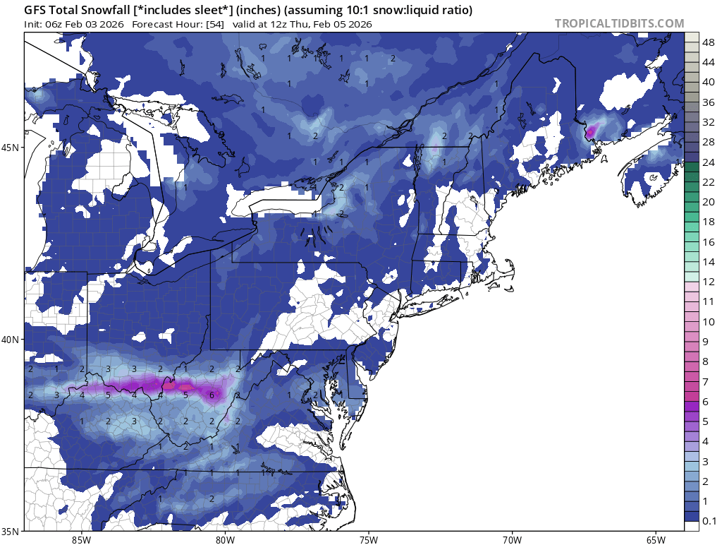
6Z GFS. Time to reel this big fish in.

-
11F. Snow Pack and clear skies doing its thing
-

E PA/NJ/DE Winter 2025-26 Obs/Discussion
MickeyTim6533 replied to LVblizzard's topic in Philadelphia Region
man, this place is a morgue