

BornAgain13
-
Posts
4,468 -
Joined
-
Last visited
3 Followers


About BornAgain13

- Birthday 07/02/1988
Recent Profile Visitors
11,912 profile views


-
The Severe threat for Monday continues to increase for sure.
-
Deck _2026-03-12T17_34_53.mp4
-
Snowing good out in Dry Fork!! 86 yesterday. 33 now
-
Been watching this time period. A lot of guidance has shown flashes of something around then. Something to watch.
-
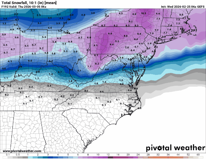
Last 3 runs of GEFS for next week
-
12z GFS for next week continues to trend south. Shows a decent Snowstorm for southern VA north.. UK has showed it several runs in a row and so has the Euro AI
-
The Euro holds weight but its not the king in my opinion.
-
Been quite some time since the NE saw a Blizzard like this thats about to happen. Gonna be some SnowTV!
-
6z NAM just dumped 30"+ on SE VA. Lol
-
The GFS is either gonna score a huge win on this or its gonna be an embarrassment... unreal how much snow its putting out now. I can't imagine being a met around those parts making a forecast
-
GFS is the only one showing that much snow. I hope they aint relying on that
-
18z GFS shows more snow in the first few days of March, a little like the 12z EURO
-
Wow.
-
This weekend isn't far from trending to something at least light for the upper SE
-
Been watching this weekend's storm on and off. Mostly looks to hit north of here, more so Northern VA and into the NE. Could be the storm they've been waiting on!


