All Activity
- Past hour
-
The gfs has done an outstanding job of sniffing out these storm cycles this year. When I’ve seen that darker blue precip shield sitting over the northern greens for 18-24 hours on a nw flow flow show up for 3-4 runs in a row, you can almost lock in an 18” upslope party every time so far this year. Even at a 3-4 day lead time. .
-
This is most helpful. Thanks for the clarification on what is considered a trace. It also confirms my suspected conversion factor was pretty much spot on: 5280 T = 1 in. .
-
Really looks like the -NAO wants to develop. But ideally we would want it to develop a bit more to the west and force some blocking across northern Canada and Greenland. But I believe east -NAO are good flow slowing storms down on the Atlantic side. That being said, you need help from the pacific as well but as long as Alaska stays cold and stormy, I’m not sure we’ll get much help. Looks like northeast will be the only place colder than average for the rest of the month. Been a torch across most of CONUS this entire week and will likely prevail into the new year. Places down south that we’re running 10 degrees below normal will finish around average from this torch. Warm Christmas for many, doesn’t look like that pattern will Let up through early January.
-
I grant that a few flakes may have been seen in the air on these dates, but nothing was measurable. If that counts as a trace, so be it. I need a skiff, or a dash, or a dusting, or a coating, or some other such word before I would call it even remotely measurable. .
-
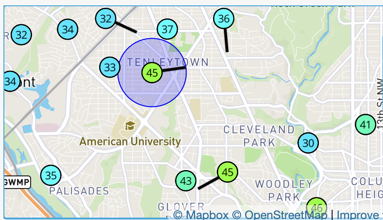
it's 47F at my house on 43rd St. A station along the same cross street but at 47th St (and probably about 80-100' lower) is at 33F. The hill we are on basically slopes down to the Potomac River, so I assume that is something. Also the wind is very slight out of the east - about 1.5-2 blocks east is a much more commercial area along Wisconsin Ave.
-
Alot of fluffy snowstorms that winter
-

Central PA Winter 25/26 Discussion and Obs
canderson replied to MAG5035's topic in Upstate New York/Pennsylvania
Wind threats are a big things Friday. Possible even 60 mph winds for some of us. -
Low of 30, high of 66. Looks like the last of the cold for a bit.
-

E PA/NJ/DE Winter 2025-26 Obs/Discussion
Albedoman replied to LVblizzard's topic in Philadelphia Region
E PA/NJ/DE Autumn 2025 Obs/Discussion Albedoman replied to PhiEaglesfan712's topic in Philadelphia Region in October My forecast did suggest a slow start. Enjoy the fall weather while you can. Come january you will be wishing for temps above 45 . I expect more mix events than anything else in late nov into mid dec as the pattern sets up for january------- well I was pretty close. We will get 1-2 days this week above 45 degrees. Thank god it will melt the .50 in of snow equivalent liquid precip with the expected 1-2 inches of rain. That will help the drought somewhat for the stream base flows but the main problem is that the frost in the soil horizon is already pretty deep especially in the LV. The groundwater is likely not going to be recharged at all. You will see real muddy conditions in the yard for a few days as the topsoil is unfrozen, but then back into the deep freeze. I would love to see t storms Thursday night. The snow will quickly disappear with sublimation from fog and from the heavy rain. The down trees on Friday will be a huge problem from the winds as the soils around the tree roots will soften up just enough to be wind thrown before freezing. Main concern for me, if it rains hard enough Friday afternoon, the expected winds may not dry our the road surfaces from the excessive ponding and we will have flash freeze conditions Friday evening in many areas. Saturday morning may not be very nice around our region. Also, my utility bill is doubled from last year according to my usage and I still have have a 15 days to go. Going to be many homeowners wishing they had not spent so much on Christmas gifts come mid January when they get their utility bill. This chart says it all just posted by Mt Holly. -
Always interesting tweets from the British weenies. Did it get cold in January 77?
-

December 2025 Short/Medium Range Forecast Thread
Matthew70 replied to John1122's topic in Tennessee Valley
There is winners & losers in any pattern as we all know. Even with the Chinook here in TN it’s been a cold December so far. At least it’s felt & looked on some days like a wintry Christmas. I think I saw where Chicago was off to a great start for snow? Maybe it was the snowiest in some time? Even ND has had a lot of snow. The pattern will change, and there will be winners & losers again with the reshuffle. I just think many have forgotten winter has officially not even started for most. We’ve been cold enough so far in December to actually have snow showers & dustings for many. Anytime you get snow in December is a huge bonus. January is usually dry & cold. February is the usual timeframe for Middle & West TN to receive snow. Anything in January is a 50/50 shot. Crazy to think higher odds for here are in February. So it’s warming up some, which I for one hope it hangs around till day after Christmas. That way I don’t freeze taking down the outside decorations. -
What one considers a “big” storm is sort of arbitrary/subjective, so there’s certainly room for pushback. But your comments help to make the point – I can’t even tell you when those two 20” cycles occurred. I’m not sure if anyone in the forum other than you knows when they happened. Most likely they were “nothing” events in terms of their impacts on the majority of the Northeast. There have only been three TWC named winter storms so far this season, and they all impacted us and are in the list below, but none of them were named for their impacts in our area because their effects here were minor as you can see by their accumulations at our site. Alston and Bellamy earned their names because of impacts in the Midwest, and Chan was named because of impacts off to our south. If you look at this list below of the 18 storms that have hit our site so far this season, it’s loaded with Clippers, cold fronts, and shortwaves. My main argument was that the Mansfield stake has reached record depth without being in the sweet spot for any major synoptic storms. If someone told me that Mt. Mansfield had reached a record snowpack depth for mid-December, I’d assume there had to have been at least a couple of major synoptic storms in which our area was in the perfect position to cash in and get a ton of snow. But that hasn’t been the case. And, what’s more interesting is to consider that perhaps the record depth wasn’t achieved just in spite of not getting hit by those big synoptic storms, but the record depth was actually achieved because we were in a pattern that wasn’t conducive to creating big storms. What has transpired so far this fall just proves that it’s not necessary to have multiple perfectly placed coastal storms to achieve a record mountain snowpack around here - that’s the part I find most counterintuitive and intriguing. Below is the list of accumulating storms that have affected our site so far this season, and it should be just about the same list for the local mountains. The description of each storm is included, and none of them were big coastal systems. The closest to a typical nor’easter was Winter Storm Chan, but it was still quite weak, and its effects this far north were fairly minimal (only 4.8 inches for a storm total at our site).
-
2013-2014 was pretty damn good too.
-
In January yes, February not so much.
-
Legit wild - I went from 32° to 38° in like 10 minutes an hour ago, back down to 35° now
-
It’ll be 45° during tomorrow morning’s bootcamp workout…now if the rain could just hold off for a couple hours it would be glorious. 6-9” is big snow in this here land of hit or miss clippers and dry bone breaking northwest flow.
-
Hurricane Josh's Melissa chase is up. Insanely intense. Up there was the Marsh Harbor footage in Dorian.
- Today
-
46F here and rising (most of my snow has been obliterated) while DCA is at 35 and dropping lol. Don't think I've seen that type of spread before absent it raining in one location and not the other.
-
Every CAM has a nice forced line just ahead of the front, with consensus showing it passing through DC around 6 or maybe 7AM. Most of these events end up being just heavy rain, but they do occasionally surprise us with more. Another thing to watch is that all of the guidance has another round of scattered heavy showers around midday in a well-mixed environment with a bit of low-level CAPE and low freezing levels. Would not be surprised to see some graupel out of those.
- 1,372 replies
-
- 1
-

-
- severe
- thunderstorms
- (and 2 more)
-
Yep saw that this evening. Nothing you can do but hope the pattern changes and brings more snow to the area.
-
My shaded ground is frozen solid and full sun is hazardous as too 1/4” is melted clay much but still frozen right underneath. Fast drop down to 35 now
-
2010-11 was by far the best snow cover winter I’ve ever seen.
-
This was Islanders Pond, VT yesterday. You don’t have to watch the entire video lol. Very nice for opening day. And I had to work
-
this is insane lol
-
49.5F here. A WILD inversion going on right now around here - it's 45F here, about 4 blocks away and downhill, it's 33F lol.


