All Activity
- Past hour
-
It was TS Erin in 2007 over Oklahoma. I have to check but I thought Erin formed around the same spot S of TX as this to-be ghost of Erin but higher intensity over OK than the gulf.
-
I can remember some night squall lines just like that back in the 90s. .
-
92/67/100 10th 90 plus of year but not a heatwave as yesterday only got to 89. Have only 1 3 day heatwave thus far
-
.thumb.jpg.6a4895b2a43f87359e4e7d04a6fa0d14.jpg)
Central PA Summer 2026 Discussion/Obs Thread
Yardstickgozinya replied to Voyager's topic in Upstate New York/Pennsylvania
I completely agree, chances are this will be sporadic at best and that's perfectly fine. However, the one thing that all the top dogs have in common is the presence of the EML. It seems to be the main deciding factor between more of the same and a true widespread sig/svr weather when other enhanced indices are present. -
I’m trying to recall, was it Ivan that become such a beast over middle America as a hybrid low? Memory fails me. .
-
Word, ready to comma head mcs tho
-
92/64 split today... 4 day heat wave .
-
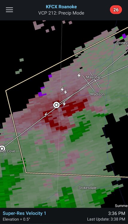
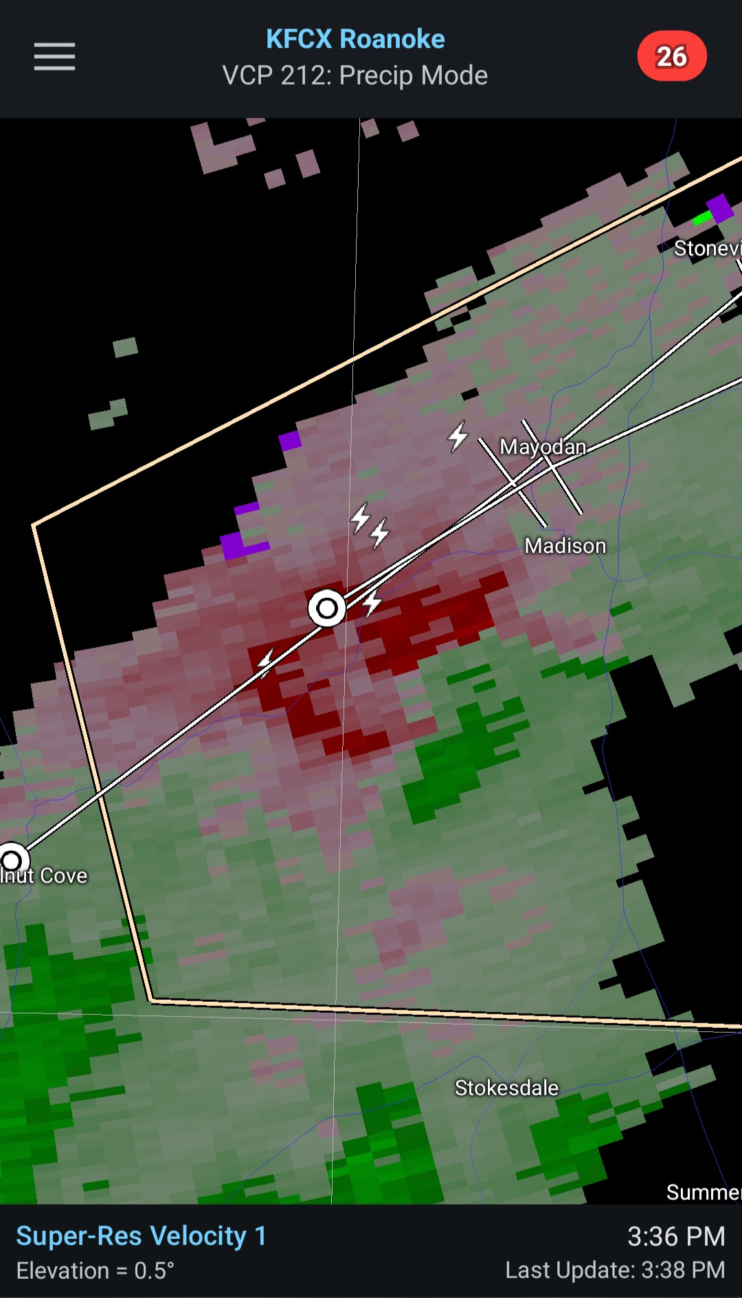
Some rotation showing between Madison and Stokesdale NC.
-
gonna go ahead and call a miss north/west here, and will hopefully be proven wrong
-

Pittsburgh PA Summer 2026 Thread
jwilson replied to TheClimateChanger's topic in Upstate New York/Pennsylvania
Severe Watch until 9 PM, but it has been pretty cloudy around here today, so I imagine that caps some of the potential. NWS did mention a possible tornado watch to come, but TBD. -
When all is said and done, Peoria to NWI gonna be the hot spot again.
-
It's been raining down your way. Looks like you're getting more today. It's been dry up here.
-
Wagons north?
-
Clouds kept temps down a bit here. Still 84 which isn’t bad. Forecast was 88
-
Central PA Summer 2026 Discussion/Obs Thread
Yardstickgozinya replied to Voyager's topic in Upstate New York/Pennsylvania
I'm not familiar with that outbreak. However, it was a major player in the 5/31/85 outbreak for western pennsylvania. An additional component to the magnitude of the thunderstorms on May 31st was the presence of a significant “elevated mixed layer” (EML) , a common supporting ingredient in severe weather across the northeastern U.S. (Banacos and Ekster). EMLs act as a ‘lid’ in the atmosphere, stopping convection from occurring unless the lid can be removed or sufficient lift is present. The strength of the front and the degree of instability lead to the erosion or breaking of the cap and thunderstorms exploded with violent results. This following two figures from Markowski show 1, the presence of the EML in the 7pm May 31st Pittsburgh sounding and 2, the formation and subsequent migration of the EML across the United States. The following hand-analyzed upper air maps (provided by NWS Cleveland) from the morning of the 31st highlight the significant area of dry air (yellow shading) or ‘cap’ coming into play. The forecaster even analyzed a dryline (the bumpy blue line through the central Plains) on the 850mb map, showing the leading edge of the dry air. -
There it is... 80%... watch needed soon https://www.spc.noaa.gov/products/md/md1141.html Mesoscale Discussion 1141 NWS Storm Prediction Center Norman OK 0217 PM CDT Sun Jun 14 2026 Areas affected...portions of Virginia...far southern Pennsylvania...eastern Maryland Concerning...Severe potential...Severe Thunderstorm Watch likely Valid 141917Z - 142115Z Probability of Watch Issuance...80 percent SUMMARY...Thunderstorm clusters will move eastward with damaging wind potential into the afternoon/evening. DISCUSSION...Thunderstorm activity across the Shenandoah Valley and Blue Ridge Mountains will increase in coverage and intensity as they shift eastward into the more favorable air mass across central/eastern Virginia this afternoon. Additional thunderstorm development is likely downstream of the ongoing activity, with several areas of deepening cumulus noted in visible satellite. Mostly sunny skies through the morning has allowed for strong daytime heating and warming, with temperatures warming into the mid 90s. Higher theta-e air is advecting northward, with around 1000-2000 J/kg across southern Virginia. Steep low-level lapse rates are noted in SPC Mesoanalysis (7-8 C/km) and in the 18z RAOB from IAD. Though deep layer shear is marginal (around 20-30 kts), very warm and unstable conditions amid steep low to mid level lapse rates will support potential for water laden downdrafts and severe winds. A watch will likely be needed to cover this potential this afternoon. ..Thornton/Mosier.. 06/14/2026 ...Please see www.spc.noaa.gov for graphic product... ATTN...WFO...AKQ...CTP...LWX...RNK...PBZ...RLX... LAT...LON 37138079 38198017 39397896 40127747 39997643 39767636 38557680 37327783 36827815 36537946 36688084 36838089 37138079 MOST PROBABLE PEAK TORNADO INTENSITY...UP TO 90 MPH MOST PROBABLE PEAK WIND GUST...55-70 MPH MOST PROBABLE PEAK HAIL SIZE...UP TO 1.25 IN
-
I just came here to ask exactly that, never seen anything like that on a modal run; I'm got. Would the NHC declare it like that TD over Senegal all those years ago if it meets criteria?
-
Will never have a cool summer again sans a massive volcanic event
-
Just got back from a week on the beach in SC. Came back to a lush lawn. Things are looking much better up here than they have all spring. It's really bad down in SC. Very little surface water. I was in the low country for a week and didn't get a single mosquito bite. That's severe drought. And it didn't rain a drop the whole time we were there.
- 264 replies
-
- 1
-

-
- severe
- mountain snow
- (and 1 more)
-

2026 Mid-Atlantic Severe Storm General Discussion
high risk replied to Kmlwx's topic in Mid Atlantic
You’re not wrong that there are some factors working against this setup, and there are some legit questions about storm coverage. That said 1) dynamics are much better today - synoptic lift will be overspreading the area later today 2) we’re still several hours from game time for most of us, and better moisture should be arriving 3) while cape will be lower today compared to a few days ago, shear is way better.- 683 replies
-
- 5
-
-
- severe
- thunderstorms
- (and 7 more)
- Today
-
90/66 Need rain, like 1-2". Another quarter to a half inch won't do anything.
-
Looks like some training supercells in Maine
-
that's more than the entirety of some of our cooler summers
-
Interesting storms today. The shear is there, instability lagging as usual. Meh from BTV, but big beam blockage. I've been keeping an eye on Canadian radars for our northern storms, and this is something... That sure looks like a TDS in the Northeast Kingdom.
-

E PA/NJ/DE Summer 2026 Obs/Discussion
RedSky replied to PhiEaglesfan712's topic in Philadelphia Region
Hrr has critically needed showers 3k nam is a dry disaster


.thumb.jpg.a628c2147efdff1c820341d5143d9237.jpg)

.thumb.jpg.ad3a2e31d30aff035044689b311a0540.jpg)


