All Activity
- Past hour
-
Put 1.7 in the bucket with that one so that puts me over 2in locally. At least thats something. That and the incoming cold snap ought to trigger the Morels that haven't flushed yet to do so and the areas that have, to do it again, hopefully. Double flushes of mushrooms DO happen so if your favorite spot popped early because of the wet and the cold/heat/cold/heat cycles over the last month check them again over the next couple of weeks. Cold snaps shock them into fruiting. I've had 2 spots double flush this year. Been the best year in while for me, I'm over 400 bagged. Hell found 50 in my front yard 2 weeks ago and it hasn't flushed since Covid. They are finicky lol
-

2026-2027 El Nino
Stormchaserchuck1 replied to Stormchaserchuck1's topic in Weather Forecasting and Discussion
It looks like the 26c isotherm has made it down the thermocline. Doesn't get much warmer than that. I mean, there's not a perfect correlation of subsurface making it to the surface, but it is pretty high +time. I have also theorized that subsurface anomalies on the thermocline effect the N. pacific pattern, and we are seeing that on current models in May with more +PDO-type patterns, n. pacific 500mb low pressure It must be interesting for deep sea fish in the area to go from 65 degrees to 80 degrees (El Nino) to 55 degrees (La nina), all along the equator. Maybe some interesting evolutions there. -
half and half here
-
Whoa !
-
Kinda chilly out there. Upper 40s.
-

2026 Mid-Atlantic Severe Storm General Discussion
southmdwatcher replied to Kmlwx's topic in Mid Atlantic
I was in the supercell 24 years ago as well. Very heavy rain HP supercell and then the back half of the storm passage was all hail. I did see what became the 2nd tornado/waterspout as this storm crossed into the Bay....but overhead in southern St Charles...rapidly rotating funnel maybe no more than 100 to 200 feet above us. The trees were swaying but none fell. That was immediately preceded by some clearing and the steam coming up from all the hail. Just an incredible storm. I drove down to La Plata and I remember so many windows busted along the way by hail. Then seeing the guard rails wrapped around the tops of the trees a considerable distance away from the 301/Rt 6 intersection. Wild stuff. -
0.46 for me this morning. Nice!
-

E PA/NJ/DE Spring 2026 Obs/Discussion
Birds~69 replied to PhiEaglesfan712's topic in Philadelphia Region
By a week or so? And the fruit world would be catastrophically destroyed this season? Drought guy said the freeze was 2 weeks ago which is around mid April. Doesn't sound super late? I think things will be just fine...perhaps a record setting over abundance. 57F, heading to the 40s. -
It’s shorts weather everyday once mid Morch hits. I’ve had shorts on since then .. other than some cold morning runs .
-
I just got back from Sarasota a couple days ago from a family wedding and mini vacation and man this is a tough adjustment. 80 nearly everyday with a gentle breeze in the evening and walking around in shorts everywhere is hard to beat. I did get a bit of a burn on my upper back and shoulders but it’s totally worth it just having that nice change of pace for a while!
-

January 25-26th, 2026 Final Storm Totals
Baroclinic Zone replied to The 4 Seasons's topic in New England
Ahhh, reminiscing. 1 of 2 20”+ storms this year. -
by the way, this large hail storm was right at Springfield MO
-
Tomorrow will see temperatures reach the lower 60s. Another shot of rain will arrive. A general 0.50"-1.00" rainfall appears likely tomorrow into Thursday. Following the rainfall, temperatures will top out in the lower 60s through Saturday. May will likely open with cooler than normal conditions. Sunday could be especially cool with highs only in the upper 50s. The ENSO Region 1+2 anomaly was +1.5°C and the Region 3.4 anomaly was +0.7°C for the week centered around April 22. For the past six weeks, the ENSO Region 1+2 anomaly has averaged +1.47°C and the ENSO Region 3.4 anomaly has averaged +0.27°C. El Niño conditions will likely develop during late spring or early summer. The SOI was -15.07 today. The preliminary Arctic Oscillation (AO) was +0.394 today. Based on sensitivity analysis applied to the latest guidance, there is an implied near 100% probability that New York City will have a warmer than normal April (1991-2020 normal). April will likely finish with a mean temperature near 55.2° (1.5° above normal). Supplemental Information: The projected mean would be 2.2° above the 1981-2010 normal monthly value.
- Today
-
18z HRRR is insistent on //some// rain for everyone, but it really tries to run a few decent thunderstorms north of I-66 that drop localized 1" amounts.
-
Drove the pike to Lee today, still full stick season at 1,700 feet in Becket
-
Let’s make a plan together to “MYLGA”
-

The "is it ever going to rain again?" discussion.
JenkinsJinkies replied to JenkinsJinkies's topic in Mid Atlantic
-
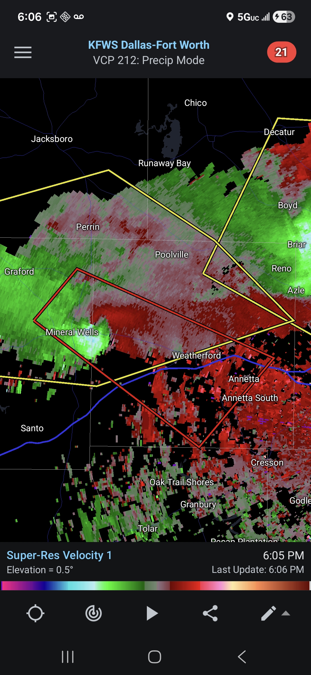
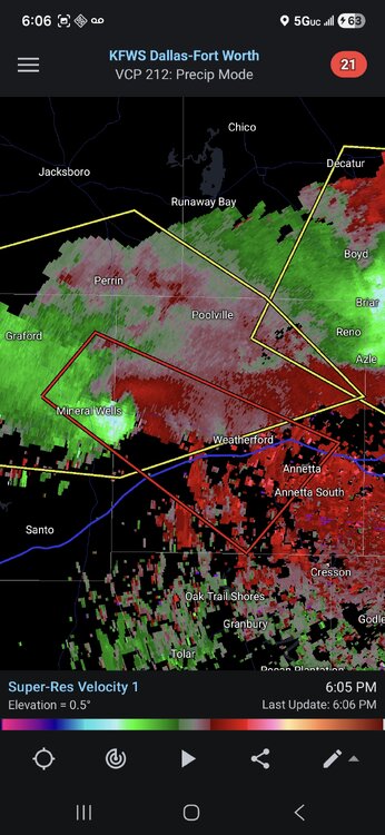
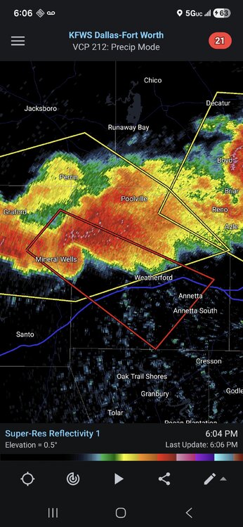
Decent couplet on the cell near Mineral Wells TX. Solid radar presentation as well.
-
dangerous supercells near Fort Worth
-
Peak wind gust of 67MPH at ARR yesterday afternoon with the wake low, just down the road from home. Had isolated to scattered branches down around town. ORD had a peak wind gust of 54MPH.
-
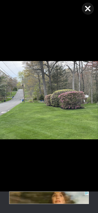
I won't trigger your OCD with a picture of my "lawn". It is, unfortunately, mostly weeds.
-
Looks frieken fabulous!
-

E PA/NJ/DE Spring 2026 Obs/Discussion
RedSky replied to PhiEaglesfan712's topic in Philadelphia Region
It was a record late freeze in many areas -
E PA/NJ/DE Spring 2026 Obs/Discussion
Birds~69 replied to PhiEaglesfan712's topic in Philadelphia Region
Isn't this around normal (last freeze) around these parts? What makes this year especially bad? AI Overview The average last spring freeze (32°F) in Philadelphia usually occurs between late March and mid-April, with central city areas often seeing their last frost around April 4th–5th and suburban or outlying areas frequently experiencing frost as late as April 15th–20th. A safe, conservative date to avoid damage to sensitive plants is often considered mid-May. The Old Farmer’s Almanac +4 Average Last Frost Dates: Central Philadelphia/Franklin Institute: ~April 4-5 Suburban/Higher Elevation: ~April 15-20 Risk Period: A 30% chance of frost remains up until April 25 in some areas. -

Central PA Spring 2026 Discussion/Obs Thread
canderson replied to Voyager's topic in Upstate New York/Pennsylvania
Ugh. Last I heard was they were think a 30-40% crop reduction. Very sad.