All Activity
- Past hour
-
Any snow coming to north Georgia Monday afternoon?
-
Didn’t it get up to something like 90 degrees or close to it in Traverse City in March 2012? There’s not many guarantees in weather but I can guarantee Traverse City isn’t getting that warm this month.
-

Fall/Winter Banter - Football, Basketball, Snowball?
GBOVolz replied to John1122's topic in Tennessee Valley
FYI… I ate lunch with Mike Witcher and Anthony Cavallucc. We had some great conversations and it was really cool. I got to learn a lot of stuff that I didn’t know about the weather and just how everything works at MRX. I’m not sure if this is common knowledge and I haven’t heard this but apparently the WPC is going to take over the forecast duties for all of the local NWS stations. I think he said they already do the 4 to 8 day forecast and MRX does the 1-3 day forecast. . -
Too high up here but it's impossible to predict in advance where the best banding sets up. The RGEM maybe showed it best with the western snow max then second one over eastern LI. You have the western band with high ratios then the second max with the highest QPF and semi-shaft zone in between in most storms like these.
-
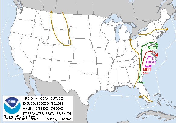
You beat me to my edit lol. I only went by the main page which showed mdt https://www.spc.noaa.gov/exper/archive/events/
-
-
There was a high risk that day in NC... mod risk was south of the LWX CWA looks like https://www.spc.noaa.gov/exper/archive/event.php?date=20110416
-
Holy smokes this looks like one hell of a storm. Kind of reminds me of the Blizzard up in Wisconsin about 7 or 8 years ago.
-
yup...not sure what vendors use as an algorithm for those wind gust products but there are as bad as the snow maps
-
Definitely work and you have to be very strategic. To be clear, unless it's a wind blown storm, I only take 10 measurements at 12z daily, not every 6-hr new-snow ob. I also have one of those fancy 40" sticks with a handle, plus an 8' wingspan, so I can space far from my feet. Helps great deal.
-
almost always overdone on models as well-got to reduce by 20-25%
-
18z GFS still has it.


-

2026 Mid-Atlantic Severe Storm General Discussion
09-10 analogy replied to Kmlwx's topic in Mid Atlantic
Yeah he cites the mid-April 2011 NC outbreak, which tends to get overlooked because of what happened later in that month, but it was substantial. I'm pretty sure we got at least TOR watches in the DC area, and of course there was a HIGH risk in NC. I think we were MOD locally. -

Severe Weather Thread 2026
WinstonSalemArlington replied to goldsborosnow's topic in Southeastern States
Have mercy -
Where are you?
-
Picked up a surprise inch of snow. Season total at 76.5”.
-
Severe Weather Thread 2026
WinstonSalemArlington replied to goldsborosnow's topic in Southeastern States
-
Mid-Long Range Discussion 2026
WinstonSalemArlington replied to BooneWX's topic in Southeastern States
-
Seen a lot February’s come up lame on the snow front through the years. Not new. To get back on topic have also seen a lot of these March defo bands with these deep big cyclones surprise on the back end snow front as well through the years. Really don’t want zero windchills with 40 mph winds and a coating come Monday.
-
Lava being cooled down a bit. Steam bath of Kilauea I bet.
-
Not shocking with the MJO and teleconnections.
-
In their defense, Chicago did barely see an inch of snow in February…and through today. But last winter was worse…which is sad if you love snow.
-
.thumb.jpg.6a4895b2a43f87359e4e7d04a6fa0d14.jpg)
Central PA Spring 2026 Discussion/Obs Thread
Yardstickgozinya replied to Voyager's topic in Upstate New York/Pennsylvania
The latest nws take on severe and snow. Plenty to be worked out yet ,but I get the feeling, this is all going to work out for the best or the worst, depending on how you look at it. Exciting times ahead. Monday continues to be a period of high focus, as model consensus zeroes in on the potential for significant convective development. At this early juncture, confidence is quite high on the synoptic-scale evolution (the approach of a negatively tilted upper-trough, an associated sharp cold front, and impressively strong wind fields at all levels). More uncertainty still has to be dealt with, though, in terms of smaller-scale factors, such as: exact timing of the cold frontal passage, can any breaks develop in the overcast conditions that should prevail to start the day (which would enhance instability)?, and convective mode (will any discrete cells form ahead of a probable intense squall line?). Bottom line, though, ultimately we have increasing levels of confidence in high wind producing thunderstorms Monday afternoon, with the best potential for damaging gusts near and south of I-80, as well as east of I-99. Please stay tuned for later updates over the next couple of days. KEY MESSAGE 2: Following Monday storminess, a period of sharply colder temperatures is expected through mid-week, with some snow possible Monday night, as the cold air first builds in. On Monday evening, once the surface cold front pushes through, colder air should rush in. At issue is how much steadier precipitation will linger behind the boundary. Given favorable upper jet placement and the probability that some wrap-around moisture will get steered into the Commonwealth, there is the potential for a quick 1-3" of snow in some areas Monday night, particularly over the higher terrain and northern sections of the state. Again, this will come down to smaller details, so it is advised that you stay tuned for later forecast updates -

Central PA Spring 2026 Discussion/Obs Thread
Itstrainingtime replied to Voyager's topic in Upstate New York/Pennsylvania
Yes, snow and cold are about the worst things that could happen IF there is widespread damage/power outages which certainly seems possible.