All Activity
- Past hour
-

E PA/NJ/DE Summer 2026 Obs/Discussion
Hurricane Agnes replied to PhiEaglesfan712's topic in Philadelphia Region
Ended up yesterday with a round 1 of 0.22" and then additional later for a total of 0.57". Then got 0.34" this morning for a 2-day event total of 0.91". The 67 low this morning was a nice break (with dps in the 60s), but that disintegrated and high dps are back. Currently mostly sunny and at my high of 84, with dp 76. -
86 / 73 steaming up
-

2026-2027 Record-breaking El Nino
mitchnick replied to Stormchaserchuck1's topic in Weather Forecasting and Discussion
It's a 3 month average and Cfs2 is showing on the monthly forecasts that December's a dumpster fire and February looks workable to great. So you're going to get goofy 3 month averages. -

Mid-Long Range Discussion 2026
WinstonSalemArlington replied to BooneWX's topic in Southeastern States
-

Augdewst 2026: Summer's Last Stand
ineedsnow replied to Prismshine Productions's topic in New England
Lets get that trough to the west and a high to the northeast of us and bring up that GFS cane! I'll take warmer weather and higher dews to pull something like that off -
It currently feels like hell...
-
Excessive heat warning for us too. Currently 97/80 for a feels like of 117.
-

2026-2027 Record-breaking El Nino
LakePaste25 replied to Stormchaserchuck1's topic in Weather Forecasting and Discussion
It worked in 09-10 but that’s because there was a TPV anchored near James Bay that could phase with these pacific systems. Without that, we’re just relying on dynamic cooling which tends to only favor snow for the mountains. Pacific jet is also usually too strong to allow a TPV to anchor up there. -

Fall/Winter Banter - Football, Basketball, Snowball?
nrgjeff replied to John1122's topic in Tennessee Valley
I am about to rage about the odd ball streaming games. Sports has become an even more crooked hack. Time to go back into the archive. All this Spanish eclipse stuff has me reflecting on 2017 and 2024 in the USA. -
One area actually got what the RRFS was forecasting. 6.41" Midlothian VA! RRFS overdid the areal coverage. HRRR was a bit high but still 2.00" max a Franconia VA not far S of DC metro. Looking at the wind reports, it appears the Appalachians barrier for bow echoes/derechoes was a big factor here. https://www.spc.noaa.gov/climo/reports/260816_rpts.html
-
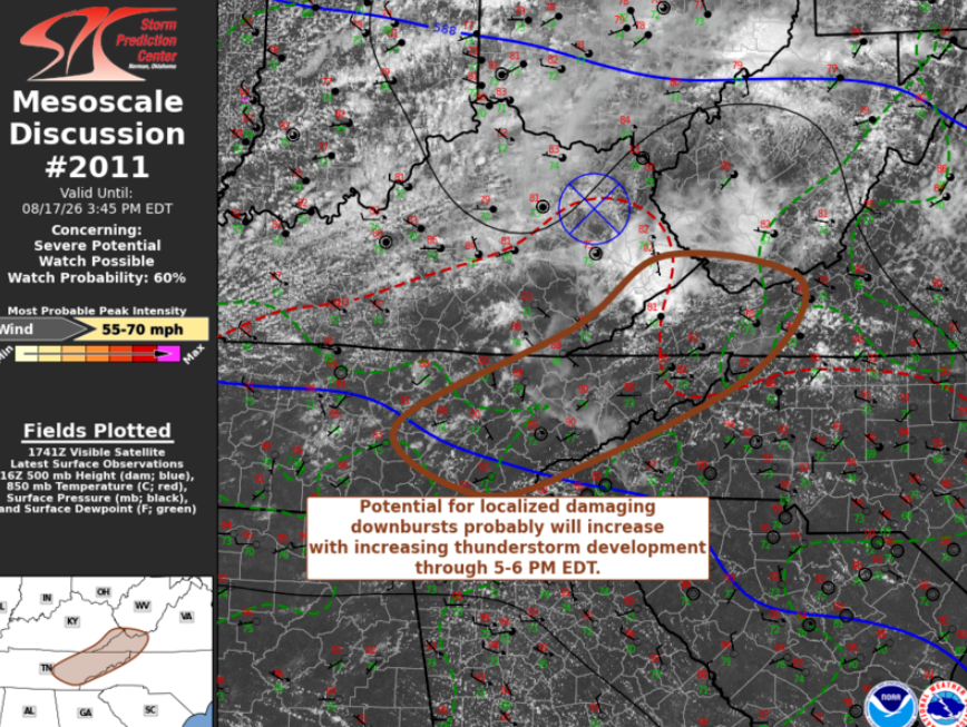
Things should heat up soon from MRX to TRI, eventually unzippering through Knox and Chatt. Monday Aug. 17 The SPC bumped up wind to 30% (not shown) but it is still Slight because no hatch. We'll see if 30% verifies. Requires the said multiple bowing segments. Otherwise 15% would do. I suspect any bowing segment would provide some nice photography. Just don't get struck by lightning. This airmass (very deep CAPE) has promoted prolific lightning for a week now.
-
No shame at all, it transforms that shot into an award winner. That's spectacular.
-
Still a long way to go to figure out the weekend, but latest runs of GFS and Euro now show a dry Saturday. They do bring in some rain for Sunday.
-

2026 Spring/Summer Mountain Thread
Maggie Valley Steve replied to Buckethead's topic in Southeastern States
Severe Thunderstorm Watch until 10 PM.png.8765888d50bfed1950b1c8099c471c54.png)
-
84 degrees with a dewpoint of 70 here.
-
 You are not going to get a deep EC trough with the Pacific like that. The Pacific is a more powerful pattern driver. They used to happen like that in the 1960s but not anymore. Model error/flaw.
 -
No kidding....I typically top my tank off this time of year and pay the lowest price per gallon. Just checked and it is $4.58 per gallon and on the rise, for comparison, I paid $2.75 per gallon last year. Most of my heating comes from a wood stove, so I really only use around 100 gallons per year. Can't imagine how much the price will be come fall, into winter, let alone what the current lock in rates are right now, I have no clue?!. Literally going to costs thousands more just to heat your home. Hoping for a warm winter for all if that is the case...
-

Augdewst 2026: Summer's Last Stand
dendrite replied to Prismshine Productions's topic in New England
I think it could break positive if the mean trough is more over the lakes. It’s not overly torchy or anything though. -
Mostly sunny here now.
-
I think that artistically the clouds added to the beauty of the photo. More artistic than scientific. (Just my opinion of course.)
-
Saw this online, and hadn’t realized how well they’ve played up to the competition. The Orioles are 18-9 this year against teams currently leading their divisions: Vs Tampa 6-3 Vs Houston 5-1 Vs White Sox 4-2 Vs Dodgers 2-1 Vs Brewers 0-0 Vs Atlanta 1-2
- Today
-
SPC has day 1 marginal risk and slight risk for both east of i65 in middle Tennessee and also in East Tennessee for 5-15-30% damaging wind https://www.spc.noaa.gov/products/outlook/day1otlk.html .
-
Currently 98 degrees and 78 DP, with an apparent "real feel" of 116. Haven't checked many inland readings but I'm sure they're worse. We considered hitting the beach this afternoon, but with winds at only between 5-7 mph, an excessive heat warning out for today, and an excessive heat watch already hoisted for tomorrow, I think we'll wait until Wednesday. It's just generally hotter than Satan's anus anywhere up and down the Grand Strand today and likely tomorrow.
-
The only option today was for a rogue shower to beeline over Frederick.
-
Mid-Long Range Discussion 2026
WinstonSalemArlington replied to BooneWX's topic in Southeastern States
Light at the end of the summer tunnel