SouthboundYank
-
Posts
1,986 -
Joined
-
Last visited
1 Follower

About SouthboundYank

- Birthday 03/25/1966
Recent Profile Visitors





-
Currently 98 degrees and 78 DP, with an apparent "real feel" of 116. Haven't checked many inland readings but I'm sure they're worse. We considered hitting the beach this afternoon, but with winds at only between 5-7 mph, an excessive heat warning out for today, and an excessive heat watch already hoisted for tomorrow, I think we'll wait until Wednesday. It's just generally hotter than Satan's anus anywhere up and down the Grand Strand today and likely tomorrow.
-

Winter 2026-2027 Seasonal Outlook
SouthboundYank replied to WinstonSalemArlington's topic in Southeastern States
Great summary, and TY for sharing this. I'm brand new to learning SE climatology, after having lived in the Mid Atlantic for the past 30 years...and there are some definite differences. -
I have some awesome pics of mammatus that I snapped in NoVA, from over the past 1-2 decades when we lived there...my favorite wx phenomenon to photograph.
-
These are INCREDIBLE pics, TY for sharing!!!!
-
Big Heat (and storms?) Week into July 4th Weekend
SouthboundYank replied to yoda's topic in Mid Atlantic
Currently 81/70 here in MB. But c'mon, man..."stifling?" You Alexandrians are beastly PROS at handling triple-digit heat in summer... -
Jan 30th-Feb 1st ULL/Coastal Storm Pics Thread
SouthboundYank replied to DTP's topic in Southeastern States
Thx for sharing the great pics, y'all...here's a video from just before 8:30 last night. Will post a few more stills from the storm and aftermath in the morning. -
The “I bring the mojo” Jan 30-Feb 1 potential winter storm
SouthboundYank replied to lilj4425's topic in Southeastern States
I personally appreciate your continued inputs, comments and obs...please keep 'em coming, if you have the time. -
The “I bring the mojo” Jan 30-Feb 1 potential winter storm
SouthboundYank replied to lilj4425's topic in Southeastern States
I remember you and always enjoyed your comments/obs from the MA sub, having lived there for the past 30+ years. I'm sorry that y'all have to be here under these circumstances (and I hope your wife is okay/improving), but hope you contribute and observe here in the SE forum while you're here. Yeah, have noticed that, too. On a whim, I pinged Google Gemini and its "Weather next 2.0" wx AI tool on the latest models and it produced this. Seems mostly common sense, with exceptions that Horry County has been upgraded to a warning and not a watch: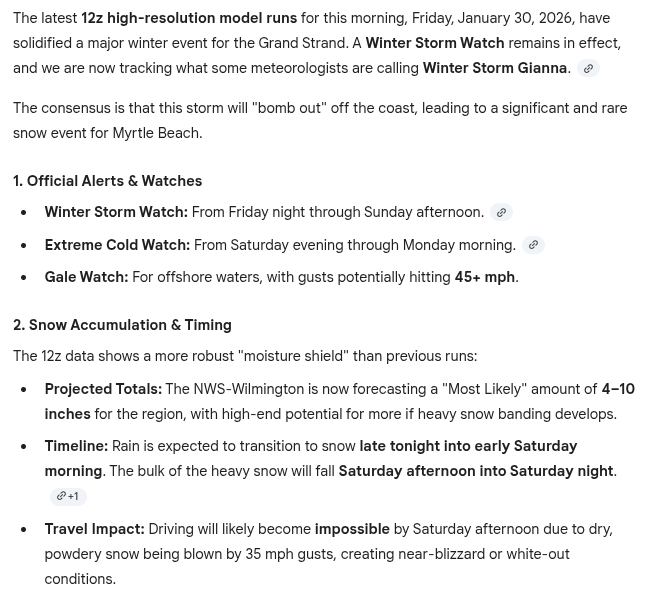
-
The “I bring the mojo” Jan 30-Feb 1 potential winter storm
SouthboundYank replied to lilj4425's topic in Southeastern States
Yeah, similar with Myrtle. Trust and believe -- I'd GLADLY give up our forecasted accumulations here in MB for everyone north and west and south of us. Of course, I know there's folks in this area that want it...so I hate to rain on their parade. Beyond never wanting to see, let alone clean up, snow again for the rest of my life after moving to MB in mid-Nov...when we were cleaning out the garage at our former house in NoVA to prep for moving I told my wife, "yeah, leave those two snow shovels here for the new owners...we certainly won't need those in MB." And now, you can't find a shovel to buy within a 30 mile radius. -
The “I bring the mojo” Jan 30-Feb 1 potential winter storm
SouthboundYank replied to lilj4425's topic in Southeastern States
VERY valid advice here. While I posted a somewhat common sense intepretation from Gemini's interpretation from WeatherNext 2.0 earlier....when I ask the same of Gemini on my GoogleTV, it tells me that highs on Sat/Sun this weekend are going to be in the 50s, with lows in low 40s, with NO precipitation. So yeah, always confirm and double-check AI interpretations...the hallucinations are very real. -
The “I bring the mojo” Jan 30-Feb 1 potential winter storm
SouthboundYank replied to lilj4425's topic in Southeastern States
LOL. You, and about half to 2/3'rds of the Mid Atlantic sub... -
The “I bring the mojo” Jan 30-Feb 1 potential winter storm
SouthboundYank replied to lilj4425's topic in Southeastern States
The past two mornings, I've fed Google Gemini this exact prompt: "What's the latest from WeatherNext 2.0 concerning the storm in Myrtle Beach this weekend?" And (again, for MB) came back with what I believe is a fair assessment of what could be potentially be arriving Sat PM: The latest 12z model runs (as of January 27, 2026) have dialed back slightly on the "blockbuster" snow potential for Myrtle Beach, but they have significantly ramped up the concern for extreme cold and a possible wintry mix late Saturday into Sunday morning. Here is the updated breakdown of what the models are signaling: 1. The Storm Track (Saturday Night - Sunday) The models are now converging on a "Coastal Low" that will track further offshore than initially hoped for by snow-lovers. The Transition: Instead of a pure snow event on Saturday morning, the 12z data suggests Saturday will likely remain overcast and raw with a high of 38°F. The Window: Precipitation chances increase to 67% late Saturday night (after 10:00 PM) as the low-pressure system passes. This is the critical window where rain is expected to transition into sleet or light snow. Sunday Morning: Models show lingering moisture as the Arctic air truly arrives. Expect a potential for light snow flurries early Sunday morning before the system moves out. 2. The "Deep Freeze" (The Higher Certainty Event) Regardless of how many flakes fall, the models are 100% certain about a historic drop in temperatures. Lows: Saturday night will drop to 23°F. Sunday night is projected to be even colder, reaching 18°F to 21°F. Highs: Sunday will struggle to reach 32°F (freezing), which is extremely rare for Myrtle Beach. Winds: North winds at 15–20 mph will keep wind chills in the single digits to low teens all weekend. Weekend Comparison: 12z Run vs. Previous Data Metric Previous Run Latest 12z Run Trend Snow Timing Saturday Morning Sat Night / Sun AM Delayed Precip Chance 45% 67% Increasing Sunday Low 21°F 18°F Colder Accumulation Dusting possible Trace to 0.5" Stable -
Got down to 21 overnight. Certainly didn't expect that when we moved here 2.5 months ago...
-
The “I bring the mojo” Jan 30-Feb 1 potential winter storm
SouthboundYank replied to lilj4425's topic in Southeastern States
Good early reads, and TY all...but you know, if that would come to fruition, I'd gladly ask the snow gods to send that modeled wx to any of the surrounding environs except Myrtle Beach. Having said that, The Wilmington NWS team posted a good afternoon disco concerning the upcoming weekend...I couldn't include all of it in the screen cap, but there was a good two paragraphs of all of the moving pieces prior to what I pasted below.