

WVclimo
-
Posts
5,244 -
Joined
-
Last visited
About WVclimo

- Birthday 03/21/1963
Recent Profile Visitors
10,368 profile views


-
1.20” and more on the way.
-
Heavy rain here. No thunder, lightning or wind.
-
Finally getting raked here. It’s raining about as hard as it can rain. Winds gusting above 40 mph.
-
Watched for an hour as a storm on radar took direct aim on my yard. It dissipated just before it arrived. Sun is back out.
-
Picked up 0.51” of rain after several hours of thunder from numerous storms nearby. Martinsburg scored with 1.41”
-
The warned cell formed a mile to my southeast. Been watching it build as it slowly pulls away. Continuous house-shaking thunder under sunny skies.
-
About 1/4 mile visibility here this morning in dense fog.
-
That warned cell in southern PA just to my north has been dumping for the past hour. FFW up for that area. Getting a lot of thunder and lightning here from it and some gusty wind. Looks like it may slip just east of here though. Edit- Storm developed right over me on the outflow boundary. Pouring for the second time today.
-
Got a direct hit here with loud cracks of thunder, and winds gusting above 40 mph. Knocked temps down from 96° to 76°.
-
97° in the shade. 105° in the sun.
-
When I go to that link, it takes me straight to weather.gov without any issues. For the local WFO, try this one: https://www.weather.gov/lwx/
-
New STW up for my yard Severe Thunderstorm Warning MDC021-043-WVC003-037-065-191845- /O.NEW.KLWX.SV.W.0147.250619T1744Z-250619T1845Z/ BULLETIN - IMMEDIATE BROADCAST REQUESTED Severe Thunderstorm Warning National Weather Service Baltimore MD/Washington DC 144 PM EDT Thu Jun 19 2025 The National Weather Service in Sterling Virginia has issued a * Severe Thunderstorm Warning for... Washington County in north central Maryland... Northwestern Frederick County in north central Maryland... Northeastern Jefferson County in the Panhandle of West Virginia... Central Morgan County in the Panhandle of West Virginia... Berkeley County in the Panhandle of West Virginia... * Until 245 PM EDT. * At 144 PM EDT, a severe thunderstorm was located 7 miles northeast of Greenwood, moving east at 50 mph. HAZARD...60 mph wind gusts. SOURCE...Radar indicated. IMPACT...Damaging winds will cause some trees and large branches to fall. This could injure those outdoors, as well as damage homes and vehicles. Roadways may become blocked by downed trees. Localized power outages are possible. Unsecured light objects may become projectiles. * Locations impacted include... Hagerstown, Martinsburg, Thurmont, Shepherdstown, Hancock, Municipal Stadium, Greenwood, Robinwood, Fountainhead-Orchard Hills, Boonsboro, Smithsburg, Paramount-Long Meadow, Wilson-Conococheague, Williamsport, Berkeley Springs, Mount Aetna, Mount Lena, San Mar, Long Meadow, and Wolfsville. PRECAUTIONARY/PREPAREDNESS ACTIONS... For your protection move to an interior room on the lowest floor of a building. Large hail, damaging wind, and continuous cloud to ground lightning are occurring with this storm. Move indoors immediately. Lightning is one of nature`s leading killers. Remember, if you can hear thunder, you are close enough to be struck by lightning. Torrential rainfall is occurring with this storm, and may lead to flash flooding. Do not drive your vehicle through flooded roadways.
-
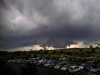
Just an awesome light show here for the last 90 minutes with the storms riding off to the NW. What’s left of the line is finally arriving.
-
After watching Charlie Morton throwing 76 pitches to get 7 outs, I am fine with never watching him pitch again.
-
Lots of thunder here with a slow-moving line of storms approaching. 79/72.
