All Activity
- Past hour
-

Pittsburgh/Western PA WINTER ‘25/‘26
TimB replied to Burghblizz's topic in Upstate New York/Pennsylvania
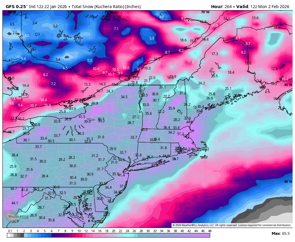
NWS point and click is showing about 11”, for whatever that’s worth. -
Yeah, next weekend has big potential.
-
He is right. The Euro is doing a piss poor job of handling the sleet aspect of this. The sleet bomb idea is real.
-
I long for the days of a storm like this...uncomplicated Miller A
-
This... I mentioned this after Mitch posted the 6z UK ensembles...the UKMET 10-1 snow maps counts sleet as snow so they are inflated on the southern end. Can't compare them to other models that don't do that...it gives the false impression the UK is further south than it is...if you just look at those maps...which you shouldn't anyways
-
I think you are thinking of 2/13/14….the 2/5/14 storm was much more of a SWFE with a latitude gradient south of SNE.
-

E PA/NJ/DE Winter 2025-26 Obs/Discussion
Mikeymac5306 replied to LVblizzard's topic in Philadelphia Region
Ralph (or anyone) can you pull up the 12z GFS snow numbers after this run? I'm getting Quagmire vibes again. -

January 24-26: Miracle or Mirage JV/Banter Thread!
aldie 22 replied to SnowenOutThere's topic in Mid Atlantic
You are going to be about 19 miles due north of me...I'm counting on you picking the right spot!! ENJOY! -
I knew this thing would correct back to the SE…oh crap. That’s next weekend.
-

January 2026 regional war/obs/disco thread
Sey-Mour Snow replied to Baroclinic Zone's topic in New England
since we are in storm mode and this is pretty much the banter thread til next week.. Both storms here
-

Richmond Metro/Hampton Roads Area Discussion
RVASnowLover replied to RIC Airport's topic in Mid Atlantic
There appears to be another threat next weekend. Something to track -
Hey that's my storm, so I should get it lol. Been saying big potential in that window for coastal storm.
-
Remember what Carver said yesterday. Be nice...
-

Possible Record Breaking Cold + Snow Sunday 1/25 - Tuesday 1/27
NittanyWx replied to TriPol's topic in New York City Metro
Risk here is primary handoff to coastal and slotting. I think coastal areas, especially Jersey and ELI have a period of sleet, but the slotting on Monday with primary handoff is a tricky feature. Should still be a very soli event, just a mater o top end -

“Cory’s in LA! Let’s MECS!” Jan. 24-26 Disco
LSC97wxnut replied to TheSnowman's topic in New England
Guess NWS-Boston has seen enough, Watches are up. -
The 540 critical thickness was more important in forecasting in the 1990s when we were more limited on the model data we received. It’s definitely outdated now. Usually it can snow even with a 552dm thickness in these overrunning SWFE setups.
-
The weekend storm could be one of the most widespread we have had in a while. Some pretty large totals from icon and Canadian runs. Will be interesting once we get into short range to see if the lake will add on anything additional.... though most likely frozen by then.
-
Im heading up to VT this afternoon. Was supposed to come back sunday but I'll wait things out until Monday afternoon. I feel like we're in the window of the run up to a storm where people are nervous and pointing to everything that could go wrong. Then tomorrow the storm thread will start with "this a nowcasting event". As if that isnt true of every event.
-

“Cory’s in LA! Let’s MECS!” Jan. 24-26 Disco
weatherwiz replied to TheSnowman's topic in New England
This is why I can't wait until we get into meso model range. The mesos I think should handle this very well and this is when we can really talk about the potential for >15" totals and where those would be most likely to occur. -
There's going to be sleet. Especially here in AA county. The question is: how much sleet? GFS says not a lot, every other model has substantially more. GFS is probably going to cave, but its not certain. We're still three days out. Better confluence up top will lead to a more GFS-like solution
-
I ended up with several inches of sleet here from this one on top of 3" of snow. https://www.raymondcmartinjr.com/weather/2007/14-Feb-07-SurfaceMaps.html
-
I like this one for the Eastern areas. A one two punch coming up seems a good bet.
-

January 24-26: Miracle or Mirage JV/Banter Thread!
Kay replied to SnowenOutThere's topic in Mid Atlantic
Sounds like you enjoy it and it's part of your weenie-ing out vs just a sense of duty, which I respect haha I like being out in it, too, but walking and stuff more so than shoveling -
Mods are probably starting to pick up on downsloping .
-
If this turns into widespread 10-12" you hope there won't be a lot of disappointment here In the next few days I'll be watching out for drying midlevels showing up, especially if the trough keeps trending west. As mentioned if it goes the other way and you start seeing mesobands and mid-level magic or ivt snows then we'd start to push the expectations up. 2/5/14 was widespread 10-14" even down to DC and it was an awesome storm. Just hope a redux of that wouldn't be considered a fail.