psuhoffman
-
Posts
26,419 -
Joined
-
Last visited
6 Followers


About psuhoffman

- Birthday 08/01/1978
Recent Profile Visitors
32,061 profile views


-
This isn’t that complicated. It’s getting warmer. And no I don’t care if you can’t handle that fact emotionally. Either because you love snow so much or because you’ve tied your identity to rejecting facts that are inconvenient to your preferences. The thermometer DGAF about your feelings. Regression studies of snowfall are somewhat flawed imo because they apply increased temps to historical storms. Storms tracks depend on thermal boundaries so warmer temps mean the storms aren’t even in the same places anymore. But let’s simplify this. If it’s warmer in general meaning on the average storm tracks will shift north…well that means less snow for us because as you go south from here at similar elevations snowfall goes down. It’s that simple. The climate zones are shifting north with the temps. So what was once normal snow for somewhere in south or Central VA 30 years ago is now DC. Yes there will continue to be snowier and less snowy cycles and winters and there will be occasional big storms but the larger trend is really clear.
-
I agree with the general tone of your posts. but last winter was also typical of cold dry Nina’s prior to 2016. 2008-2009 was one of my top analogs and it ended up a really close match in reality. If the PDO relaxes as it did last year we might so marginally better than the typical 2017-2024 period of crap. But marginally because the background pattern drivers aren’t really good even in a pre 2017 era. We got low snow winters back then too lol. My gut says the last 8 years was a nadir and even in a lower new normal we will look back on it as a low point. But the next high snow tide isn’t likely to be as good as the last just like the last snowy period in the 2000s wasn’t as snowy as the late 1950s-1960s. The exception will be the random fluke anomaly events that will happen. And sure line up everything and another 2010 can even happen. But there will be longer stretches of snowless dreg in between those positive anomalies.
-
We can always hope for something like 1999-2000 when 90% of the winter was a hopeless garbage pattern but we got a 10 day window and scored multiple snowstorms. It takes epic good luck though. It’s always possible though.
-
Looks perfect to me. I’ll head up to ski this for a few days then come home in time for this


-
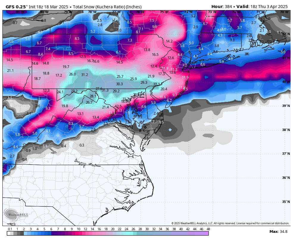
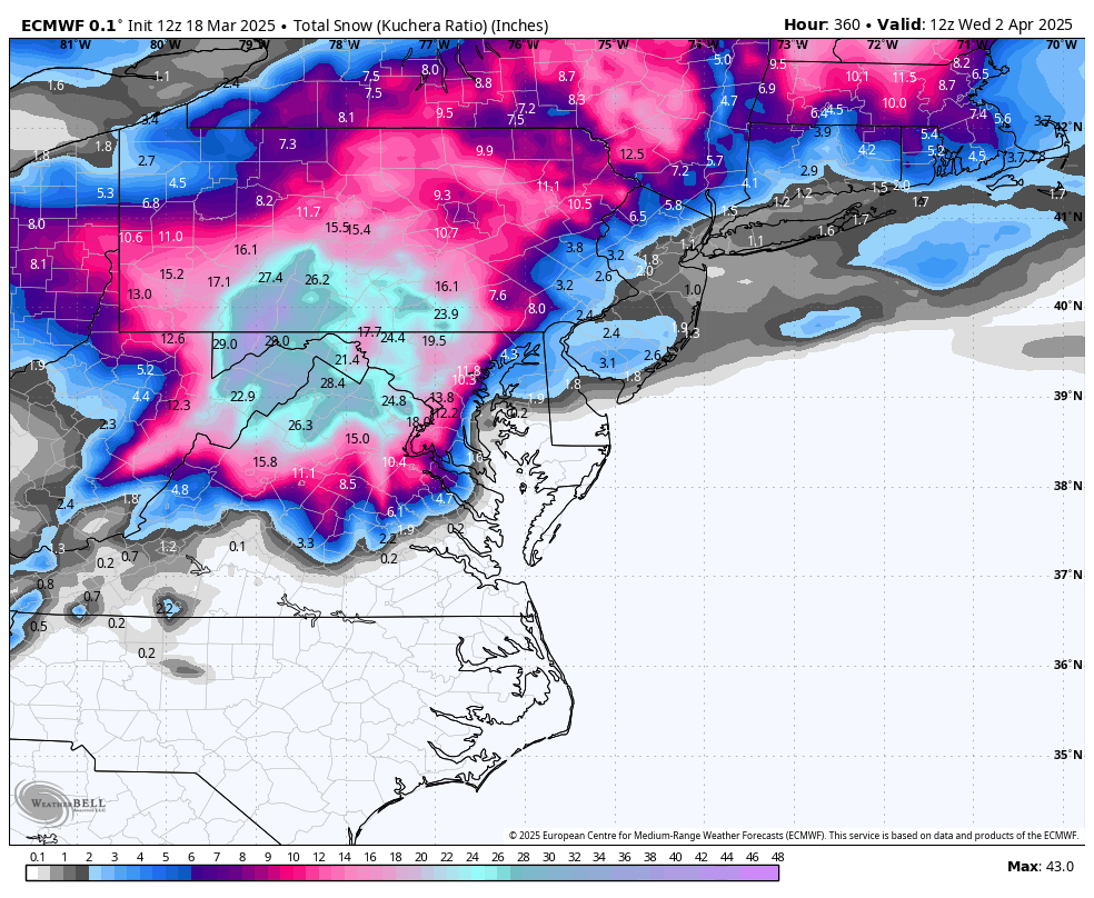
We had 2 busts in February which were legitimate modelling errors. This though, doesn't seem to me to be a good example. If you know how to use the tool this is fine. That blizzard solution is NOT the majority solution across guidance. It's a fluke that it showed up for a couple runs on the Op GFS and one run of the Op Euro. But across the full spread of guidance, operationals and ensembles, it was a 10% minority solution at best! But 10% is not 0. It is a pretty extreme pattern. There is a non zero chance some fluke snow does happen. Its most definitely a long shot and not likely to happen...but given its not zero chance...that solution will show up on an odd run of the models here or there. And if all someone does is take that one run as if its a forecast yea thats BAD. But if you look at the guidance holistically every day, you see that is NOT the most likely outcome and was just a fluke run.
-
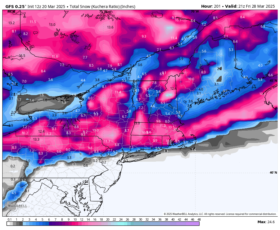
I do think the signal is there for an anomalous late season storm. But in the end the snow will most likely favor higher elevations and further north simply based on climo and time of year.
-
It does not mean it’s any more likely but it is odd to see two major operationals spit out similar crazy results at that range. Just something to log in the annals of the strange shit I’ve seen over the years.
-
Gfs smoked the same funky stuff

-
I’m not really in the mood but it’s likely going to be cold and miserable from March 15-April 1 so we might as well root for a fluke snow event. Even if it’s unlikely and probably just ends up some messy event that lets us down.
-
Im still keeping an eye on the period but we need a major amplification for it to work because the temps are meh and then we need it to happen pretty far south compared to where guidance is hinting. But it’s a non zero chance still something could pop up next weekend or early the week after. @WEATHER53 so….just getting caught up and did you decide to scrap the truce where we agreed to be civil and no personal attacks? We back to open season? Or was that a slip up the other day. Cause I ain’t said a thing about you since we agreed. I liked it more civil. Not sure why you felt the need to go into attack mode again when I wasn’t even here and the issue had nothing to do with you or models. So how do you want to proceed? I’m ok either way but if you decide you want open season that works both ways. Don’t complain and say it’s unfair when I respond.
-
It’s off topic. It’s not in the weather thread. And I found your jingoistic posts a few days ago to be political. But I didn’t try to stop you from expressing yourself I simply made my case why I disagreed. Then that ironically got shut down as “political”. But you haven’t had an issue making posts clearly articulating your ideological standpoint. Granted you do so in an ambiguous and subtle way but it’s picked up on. Don’t think I’ve not noticed. But then you complain when you have to be confronted by an opposing pov.
-
So I guess you decided to end the truce you asked for? Are we attacking each other personally again now? If so ok but then don’t you dare play some game where you complain I’m attacking you unprovoked or “stalking you” or some such nonsense. I’ve not said jack since you asked if we could be civil. If you want to go back to open season so be it but that works both ways. So what’s it gonna be?
-
I’m not going to engage in personal attacks but careful with the “love it or leave it” stuff. First of all I’ve been to many other places and it’s true our society is better than most I don’t think we are the best. There are places I think have their value more aligned to mine than here. I’d be perfectly happy there. Does that make me a horrible person? Do I have to leave? IMO being critical of your own society in order to improve it is not negative. It’s how you make progress. Should the founders not have been critical of King George? If you disagree with a point address that point. Explain why you don’t agree. Neither side (and I mean that) should use the flag as a way to stifle expression.
-
I felt I was not in the right frame of mind to be civil and didn’t want to make things a shit show so had to step away. But seeing the current state of things…not sure that matters much now. I didn’t come in here to escalate things even further. I’ll be civil. But 2 points that aren’t political. These are just facts 1) we cannot fix our fiscal problems this way. Even if we eliminated all of our regulatory and public service agencies it wouldn’t even account for half the deficit! Plus the damage it would cause to the economy would hurt tax revenues which is the other half of the equation. This isn’t politics it’s math. This isn’t going to help the fiscal mess we are in it’s just going to hurt a ton of people. If we really want to get out of fiscal hell the only viable path is to freeze spending at current levels then only increase it at inflationary increments and grow our way out over time. That’s the only way. Cutting our way won’t work because only a small % of the deficit is from discretionary spending and the damage to our tax revenues offsets the cuts. Sorry again this is basic economic and math. Not politics. 2) attacking our public servants is dangerous. But more so the cruelty I see right now is ridiculous. What’s the point of all the “welcome to the real world where people get fired all the time” comments. Yea and my whole life our culture openly despised the evils of corporate America. This is the part I really don’t get. There feels like this idea that some think public servants are their enemies. That because at some point they felt economic pain they should too. Why? Many of them are in careers where the whole point of what they do is to fight the private sectors cruel inequities! But instead of joining them you decided the better course was to make sure they suffer also? Is that who you want to be? You think teachers and meteorologist and civil engineers and environmentalists and doctors and social workers and first responders should all suffer because you aren’t as well off economically as you want to be? You think attacking the people who devote their lives to public service and rejoicing in their pain and suffering is making us a better society? That isn’t political it’s insanity and cruelty
- 873 replies
-
- 12
-

-