All Activity
- Past hour
-
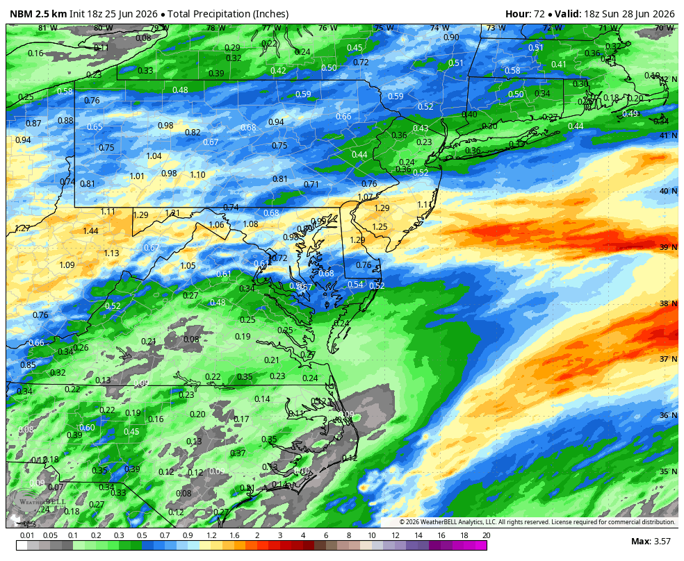
Yup. 18z NAM is rather dry. A narrow stripe of 1" - 2" along I-66, while just about everyone else gets less than half an inch.
-
Worse than Joe Namath on MNF
-
18z NAM shifts qp south thru Sunday. WPC camps out front near Winchester thru Sat morning then crawling south .
-

2026-2027 Super El Nino
michsnowfreak replied to Stormchaserchuck1's topic in Weather Forecasting and Discussion
2015-16 is exactly the kind of pattern id gamble with if forced to have a strong nino. I had largely filed that winter in the unforgettable camp, especially with the hangover from 2013-15, but after looking at it further, there were lots of winter storms in the region from late November to early April (sans December). While snowfall finished near to slightly below avg in far southern MI it jumped to above to well above avg snow in south-central MI. The caveat applies that no winters are identical, but the storminess is key, as opposed to drier ninos. -

2026-2027 Super El Nino
snowman19 replied to Stormchaserchuck1's topic in Weather Forecasting and Discussion
-
This site is struggling right now.
-
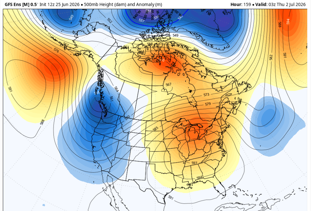
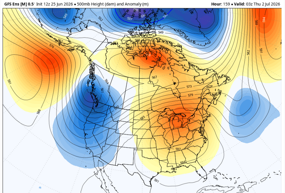
The 12z GFS for Juy 4th:
-
By the way my, site very slow for 2 days. Keep getting upload errors...

-
WB 18Z NBM; better than I expected.
- Today
-

Central PA Summer 2026 Discussion/Obs Thread
canderson replied to Voyager's topic in Upstate New York/Pennsylvania
Yea 98 am 75% humidity won’t be fun. -
Like I said, a very small movement in the total mass structure of these featured layout cleans things up quite a bit. We're on the edge ... this, below, doesn't suggest heat can't get in here. But yeah, it's also close enough that some form or another of a SW calving ( which does happen as part of our climo - ) S out over top would present challenges to getting warm here. And agree on the MCS stuff given this config Too early to call either way. The continuity of the models isn't good enough at this range for having small room for adjusting.
-
Weird the NAMS moved way north at 12z
-
Would be cool to go from this unbelievable stretch of weather we’ve had lately to 100 on Monday. It’s going to be close!
-
Yes, I vividly recall one event in July 1980. N to S cell movement w/ svr, and it was a nasty mid evening event. That's what stuck in my memory as to, "look for for storms that move N to S in hot ridge patterns!" Summer of 1980 was among the biggest heatwaves and drought on record for the CONUS.
-
At this range, I am just looking at the wavelengths and axis of the ridge. That has not changed much in the last several days overall. The point being it appears New England will be on the fence for big heat. Tastes of heat but lots of caveats present w/ cloudiness, extent of convection, and weak fronts hanging up over or just S of the region. It's not a classic Bermuda High situation w/ solid low-level SW flow for the best heat in the NEUS. But in some ways, I think this will be better if one like tstms. We don't get ring of fire solid situations every year here. Just HHH for days on end, that's get kind of boring after a awhile for some. Very warm/humid w/ bouts of tstms I think many would enjoy better.
-
A good chunk of PA isn't far off from being as bad as us.
-
It's been awhile since we've seen one of those nocturnal strobers running through southern VT/NH into NE Mass. 1990s had a few. Then...rather mysteriously, they went away. or the frequency just dropped dramatically
-
Up to 87
-
I remember back in the 70’s and 80’s we were good for at least a few nights during the summer having an intense line move from the north move south east into E MA. Rarely see a storm from that direction at all here anymore
-
Lots of discussion concerning ring of fire pattern setting up with this heatwave coming through. Honestly feeling like we'll get missed north this time around
-
 Oops. So, that’s why most others’ maxes are significantly warmer than mine. I inadvertently in my mind entered a different max temps contest than most. One other entrant @RodneyShas similarly lower maxes to mine. I wonder if he also thought it was just for June. And I saw people before me putting “June” on their entry, which further made me think the maxes also were for just June. If there’s any way you can remove my maxes picks, please do so. Otherwise, it’s ok. Maybe I’ll get lucky.
 -

2026 Mid-Atlantic Severe Storm General Discussion
high risk replied to Kmlwx's topic in Mid Atlantic
Instability looks marginal, but deep-layer shear is very good. I don't see any high-end potential here, but I would think that the updated Day 3 in an hour might contain a MRGL here. -
RGEM was showing a big soaker, but now it shifted south. I see Euro just shifted a little south. It's still a very close call, but it seems to be going in the direction of the heavier rain missing to the south for Saturday morning to early afternoon with only some light rain up here.
-

Mountain West Discussion
mayjawintastawm replied to mayjawintastawm's topic in Central/Western States
Yeah, we got 0.08"- storms really fizzled as they came out of the foothills here last night around 10 PM, no good explanation. Continuous lightning and thunder to the west, walked the dogs quickly and took the plants in, then 20 minutes later just some light rain and poof. -

Occasional Thoughts on Climate Change
donsutherland1 replied to donsutherland1's topic in Climate Change
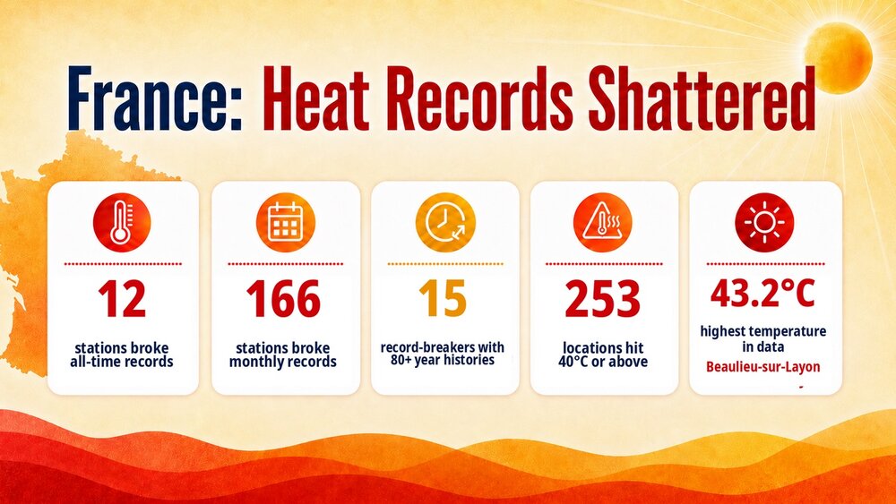
Today was another day of furnace-like heat in France, Jersey, and the UK. The extreme heat will shift eastward over the next few days.