All Activity
- Past hour
-
NWS confirms straight line wind microburst for Burke, VA, yesterday
-

2026-2027 Super El Nino
frontranger8 replied to Stormchaserchuck1's topic in Weather Forecasting and Discussion
I think the main issue with comparing the PDO from 2015 to 2026 is that was a second year Nino, which tend to have +PDO much more established by this point. Since it is a lagged response in part to ENSO. I would be surprised if the PDO is not at least moderately positive by early winter. -

Wet late Monday 6/22 or another Fizzle?
nw baltimore wx replied to Weather Will's topic in Mid Atlantic
We need some more yellows! Up to .70” on the day and about 2.70” for the month. -
https://partnerservices.nws.noaa.gov/products/cache/174-2026/PNSLWX/6fbb0920f9aef4b8b9451fd1f9c3b496 Remove if already posted, NWS preliminary survey found downburst winds in Burke up to 90mph. Reports of damage pretty extensive
-
Area Forecast Discussion National Weather Service Mount Holly NJ 110 PM EDT Tue Jun 23 2026 KEY MESSAGE 2...Another cold front is expected to approach the region late this week, bringing more chances for showers and storms. Another cold front is expected to approach our region late in the week (likely crossing through our region Friday into Saturday). More showers/storms are likely beginning as early as late day Thursday and then continuing Friday. Southwesterly flow ahead of the front should allow for plenty of moisture advection ahead of the rain chances. However with the best forcing more centered north of the region, that could limit how widespread significant rain is with this event. As for what hazards to expect with this event, that will be highly dependent on the timing of the showers and storms, which is still uncertain. The front may linger nearby next weekend and if this occurs it would keep chances for shower/storms going, especially in the afternoon/evening hours. There is uncertainty regarding this though.
-
This thing is moving slower than an anorexic at an all you can eat buffet.
-
Occasional Thoughts on Climate Change
frontranger8 replied to donsutherland1's topic in Climate Change
Not to downplay the casualties from this event at all, but that's one statistic that's a stretch to tie directly to the record heat. Heatwaves in general do increase drownings, but the evidence does not suggest that they rise in proportion to extreme heat. Heat waves increase the overall risk of unintentional drowning by approximately 17% to 26%, depending on the intensity of the heat wave. This spike is primarily driven by a surge of people seeking relief in unsupervised bodies of water. [1, 2] Key Risk Factors Activity: Swimming and bathing-related drownings see the largest jump, increasing by 28% compared to non-heat wave days. Demographics: People aged 65 and older are the most vulnerable, facing a 36% higher risk, followed by children/teens at 24%, and adults (20–64) at 7%. Gender: Men are disproportionately affected, being 22% more likely to drown during a heat wave compared to a 5% increase for women. [1] Geography & Extremes While risk generally climbs with heat, studies show that during extreme (the highest intensity) heat waves, drowning rates can actually fall slightly (to around a 9% increase), likely because the heat becomes so oppressive that people choose to stay indoors. -
nw baltimore wx changed their profile photo
-
-
2026-2027 Super El Nino
frontranger8 replied to Stormchaserchuck1's topic in Weather Forecasting and Discussion
Would not say it balanced out that month.
-
Wet late Monday 6/22 or another Fizzle?
nw baltimore wx replied to Weather Will's topic in Mid Atlantic
Making up ground, but the back edge is in sight. Probably won’t get to an inch today but grateful that today delivered after yesterdays near shutout. -

2026-2027 Super El Nino
GaWx replied to Stormchaserchuck1's topic in Weather Forecasting and Discussion
Thanks, Chris. Related to the PDO, I saw this quote today: “Waters around Japan have been cooling quite a bit lately while warming north/northeast of Hawaii.” -

E PA/NJ/DE Summer 2026 Obs/Discussion
RedSky replied to PhiEaglesfan712's topic in Philadelphia Region
Back edge approaching -
Really fortunate with storms around dark yesterday and a little shower this morning - picked up 1.15. Going to need it as it looks like we bake soon.
-
The fairly reliable S stream super-Nino fire hose pattern doesn’t typically start til after the end of the active part of the tropical season, i.e. not til November usually.
-
.80 since yesterday.
-

E PA/NJ/DE Summer 2026 Obs/Discussion
Birds~69 replied to PhiEaglesfan712's topic in Philadelphia Region
Down to 65...
-
Over 1” now counting yesterday
-
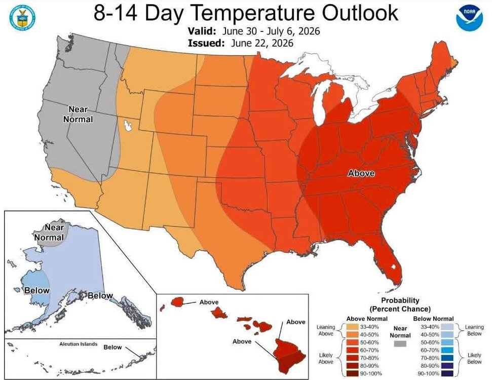
https://easternmassweather.blogspot.com/2026/06/forecast-intense-el-nino-potential.html
-

2026-2027 Super El Nino
40/70 Benchmark replied to Stormchaserchuck1's topic in Weather Forecasting and Discussion
https://easternmassweather.blogspot.com/2026/06/forecast-intense-el-nino-potential.html -
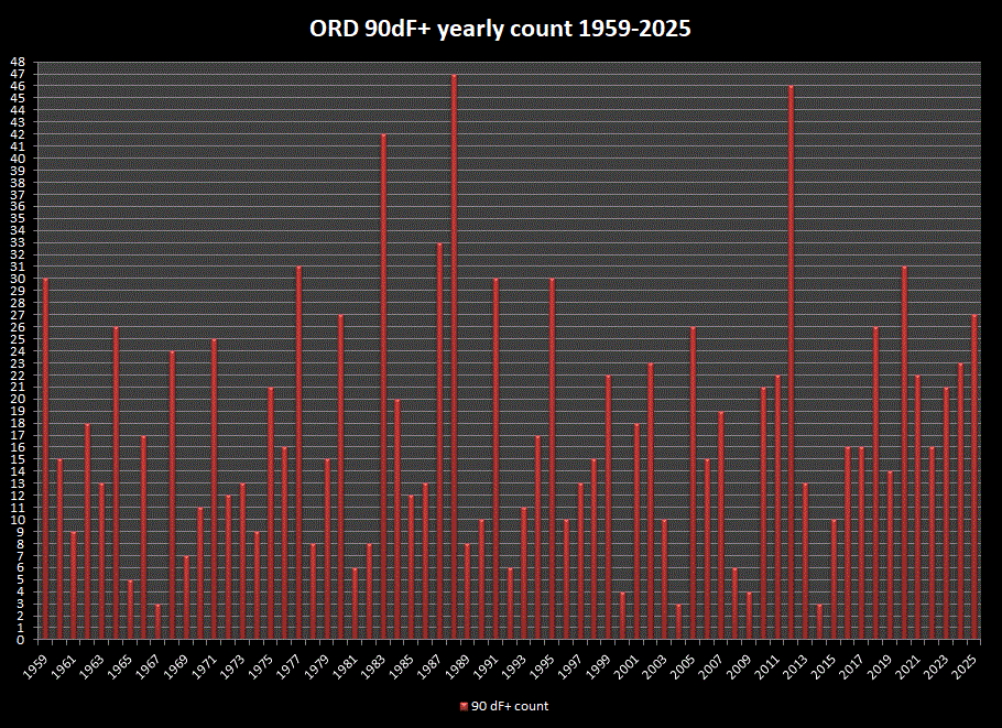
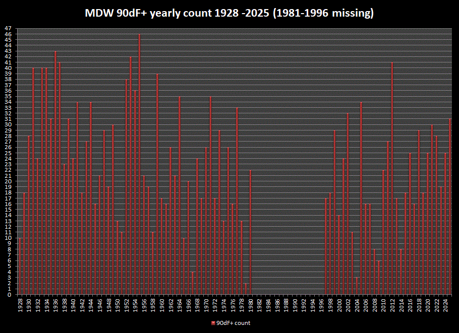
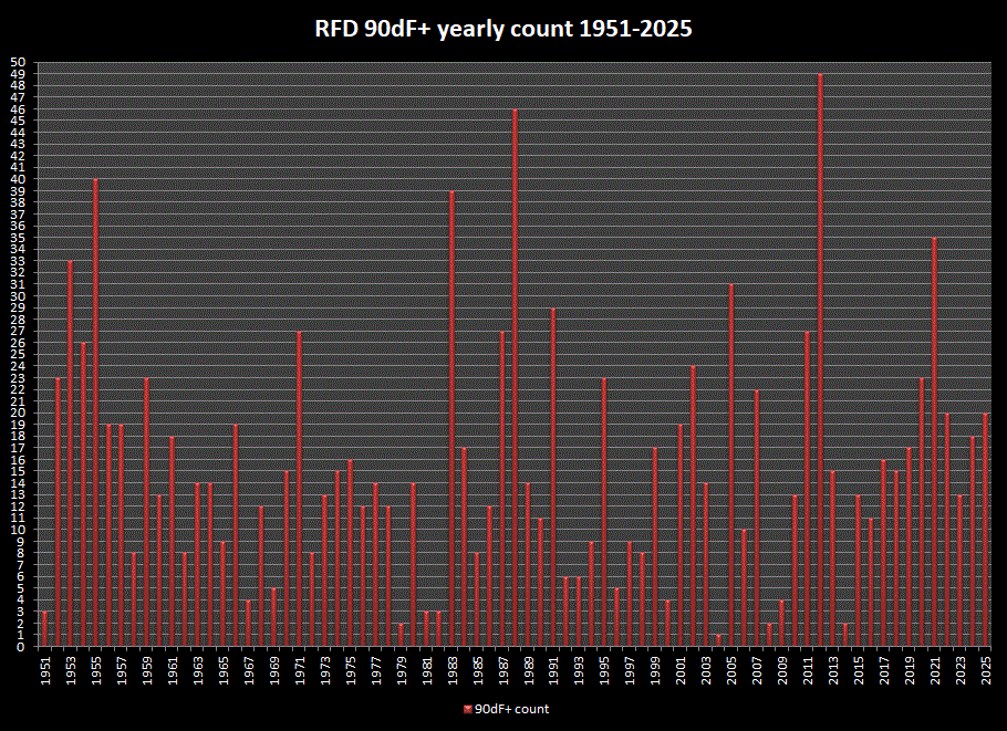
Joe, since your tracking 90dF+ days each year, thought I'd look at the longer period stns on your list, and graph the yearly counts as reference. Unfortunately, MDW has a 15 yr gap.
- Today
-
Absolutely, sorry if that came off as having a “winner” or “loser”. It’s a discussion board, so it was a little funny that after 6 paragraphs about the overuse of “heat dome”, that Tip writes a one liner about a massive heat dome in the long range. Hopefully we can see a little of the humor in that sequence of posts.
-
One hopes that before that happens the developing super-ultra-mega-El Nino will break through with a southern stream fire hose.
-
I don’t have a clear forecast like I do during Niña years. I think a moderate to strong Nino seems likely. Normally, I would just go with 70-75% of days at AN for temps with normal to AN rainfall for E TN. The other 25-30% at normal. However, recent winters have featured 2-3 weeks of bitterly cold weather west of the Apps. Granted, that is likely due to a Niña signal. However, I think those cold shots may well just be a feature of winters right now…regardless. Normally, Nino winters are rainy and dreary with a lot of clouds…nothing remarkable with temps. But…the warmer temps may well cause some convection in MJO regions 8-1-2 near the dateline. That would cause some colder rotations with the MJO which has had strong influence during recent winters. The current June CANSIPS parks a monster EPO ridge over AK for most of the winter. The seasonal Euro is warmer over the East. I lean AN for temps this winter DJF, but that is not a strong lean. As for snow, Nino winters need to really be weak to weak-moderate for best chances. But for E TN peeps, the chances for coastal storms increase which creates a feast for famine pattern during many winters. Normally, Nino winters are kind of back loaded with normal Fall temps preceding that. I could see kind of a meh December with chances in Jan and Feb.
-
E PA/NJ/DE Summer 2026 Obs/Discussion
RedSky replied to PhiEaglesfan712's topic in Philadelphia Region
Epic snow hole -
The rain in Garner was fun-for about 8 minutes I guess it was measurable lol


