All Activity
- Past hour
-
That's funny you wrote this... I was wondering how being +2 to +5 for 10 days isn't sustaining? I guess the subjective side of that needs to be brown out 100s for 10 straight days and with Locus swarms, brimstone and and booming voice from the heavens that says, "I don't like you!" lol
-
If anyone is forecasting based upon climate ( and I'm not saying that's what anyone or source actually did - ) they take risks to put it nicely. More of a philosophy of approach op ed: Climate shouldn't be used as much of any correction for any scenarios mapping at less than extremes. We look over all these modeling depictions and/or cinemas going out way in time.. comparing those to trends ( which trend is a lost/deeper art than most are aware frankly but that's another discussion - ), we get an idea of/what the biases may end up like. That's our prototype/beta forecast. Once we have that, we can/may/maybe should, reflect on whether or not climate should factor? Frankly, it won't factor very much. Why? because climate is a mean of everything that happens. It says nothing about the SDs that took place along the way - in fact... it hides them! Climate invocation should be limited to the obvious: it's probably won't snow in June; it probably won't be 90 in January - though revisit that in 30 years lol The fact that Climate Change is hugely coherent and objectively real, and cannot be denied by anyone that is not diluted ...eh hm, means that all the above is especially made more true. Because climate inference, itself, is problematic when the proverbial goal posts are moving - not just moving, but accelerating, too.
-
Cue @CoastalWxto say that is the only acceptable weather in summer.
-
Comma head of the complex seems to be moving a bit more NE now. We’ll see, but this is gonna be an interesting day for sure.
-
Yeah, dews are 70F right now up here. It’s warm and humid. It’s barely mid-June. Do we need 95F over 75F now until September?
-
IKK is the spot
-
It’s 6/11. BOS normal is 75/58 today. It’s going to be 2 weeks of WAN by Sunday. We already have powderfreak running his AC at night. I’m not sure what people want or expect?
-
Enhanced and moderate risk in the Midwest so I think it's possible
-

2026 Mid-Atlantic Severe Storm General Discussion
Eskimo Joe replied to Kmlwx's topic in Mid Atlantic
SPC mesonalayis is pretty loaded at 10:30 am for us. Incredible surface CAPE, stouts LI's, and decent low level lapse rates. Only thing lacking is shear. If something fires up today it'll have a solid airmass to work with. Hmm...even some decent mid level lapse rates west of I-81. I wonder if we have a bit a remnant EML trying to crest the mountains?- 482 replies
-
- 2
-

-
- severe
- thunderstorms
- (and 7 more)
-
Quite possibly. The latest HRRR already has a better handle, and never gets the WF back to even I-80.
-
Yeah we get it, Central Park runs cool in the summer. It has for many years. No one seems to care to fix it any time soon, so we don't really care about that 1 site either. The island was pretty much all trees before humans cut them down, so maybe that site is actually the most accurate for what conditions should be before humans stripped all the land.
-
89.0, HI approaching 100
-

2026-2027 Super El Nino
LakePaste25 replied to Stormchaserchuck1's topic in Weather Forecasting and Discussion
I do think we should still shy away from “recent nino events have featured a persistent W pac warm pool, so this one will too.” I think it’s a forecasting trap. Probably true that we deal with it much more frequently, but i don’t believe there’s enough evidence to suggest it’s a permanent feature. It’s very possibly we get clean canonical forcing by the fall. In fact I think we are on track to see that. It will just take stronger events such as this one to start seeing it. -
86/73
-
I think RDU has a shot to break the all-time record again. RAH calling for 102 and RDU has a habit of exceeding that during dry periods as you outlined
-

2026-2027 Super El Nino
George001 replied to Stormchaserchuck1's topic in Weather Forecasting and Discussion
DC-NYC yeah but Boston is a bit different in that average snowfall is in the low 40s, so our area really needs either 1 big one + several smaller events or 2 big ones. In super ninos we don’t usually see those smaller ones, and the bigger ones tend to be more Miller A due to the strong southern jet which often run inland a bit and rain in Boston or go out to sea. Thats why these super ninos tend to be not great for us. Not only do we not get those minor events that add up in super ninos, the storm track when the big one does hit if it does often screws us. It’s basically the opposite of the southern mid Atlantic, they tend to get fucked over by Miller Bs and clean up in miller As, coastal SNE cleans up in miller Bs and often gets fucked over in miller As. This is a big reason why I’m not too thrilled about the upcoming super Nino for my area, but we will see how things play out. Metfan was saying in the other thread some of the long range seasonal guidance was showing a coastal track, I’d like to see that on guidance come November. -
If this initial MCS stays further south, you think the warm front may be closer to I-80 corridor or even further south for the next round? LOT AFD sort of alludes to this.
-
To be fair, many thought it would be a cooler June, due to this being a pre-strong nino summer. Such Junes/summers are notorious for being cooler, like 1972, 1982, 1997, 2009, and 2023. The only real exceptions to this rule were 1991 and 2015, and both were preceded by a warm neutral ENSO winter. That wasn't the case this year.
-

Central PA Summer 2026 Discussion/Obs Thread
canderson replied to Voyager's topic in Upstate New York/Pennsylvania
I don’t love today’s changes. We’ll see. -
Phil will be going crazy today
-

Central PA Summer 2026 Discussion/Obs Thread
Voyager replied to Voyager's topic in Upstate New York/Pennsylvania
83/71 at 10:30am. She sure is muggy today. We've got a good deal of sun here currently, so good fuel for storms later I suppose. -

E PA/NJ/DE Summer 2026 Obs/Discussion
The Iceman replied to PhiEaglesfan712's topic in Philadelphia Region
30% wind probs today and tomorrow for most of the area... decent soaking last night for my area, picked up a quick .40". SPC day 1 ...Mid-Atlantic ad central Appalachians... Forcing for ascent from multiple shortwave disturbances across the northeast and dewpoints in the 60s to 70s F will support development of widely scattered thunderstorms by afternoon across the Mid-Atlantic into the central Appalachians. Though vertical shear will be generally weak, moderate to strong instability will be in place will support stronger updrafts capable of damaging winds. It is likely that several clusters will emerge with potential for organizing along cold pools and more focused corridors of damaging wind potential. -

2026-2027 Super El Nino
bluewave replied to Stormchaserchuck1's topic in Weather Forecasting and Discussion
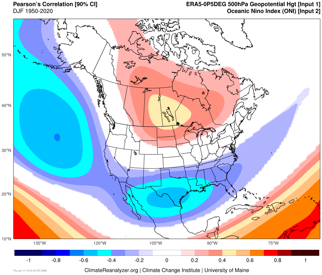
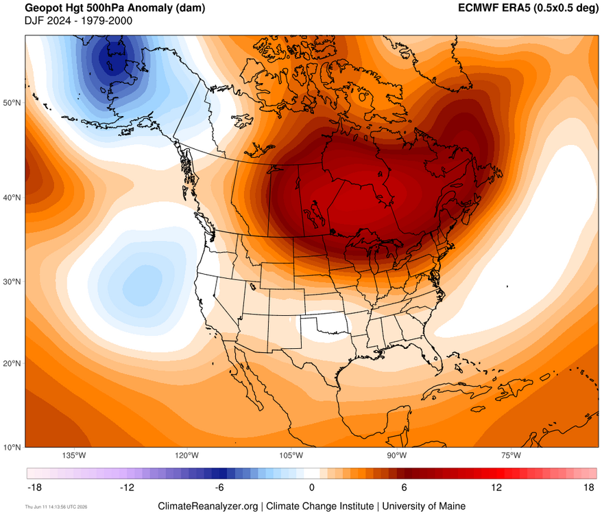
It appears that the -PDO through the warm pool east of Japan and active MJO 4-7 caused the Aleutian low to split into two weaker low pressure centers. Probably why the -1.5 RONI was so far behind the ONI. But for the Great Lakes into Northeast the El Nino ridge was even stronger than would be expected with a +2.1 ONI. Could also be the general expansion of mid-latitude ridges leading to the lack of a strong trough response in the Mid-Atlantic and Southeast.
-

Junorch obs and discussion 2026
TauntonBlizzard2013 replied to Damage In Tolland's topic in New England
Bone dry here overall. Hate to see it -
So absurd, most places have seen mean high temps in/near top 10 warmest on record for first decade of June. Philadelphia - 5th warmest; Providence, RI - 3rd warmest; Newark, NJ - 9th warmest. But Central Park is at 36th warmest. Closest analog is Worcester, MA at 23rd warmest, but their station thread includes decades from a station hundreds of feet lower in elevation.