All Activity
- Yesterday
-
Don't know if I trust ensembles or not...but the Euro AIFS ensemble and GEFS at 18z make a lot of sense, though different on several levels. The 18z Euro deterministic AIFS actually ends up w/ a strong EPO/PNA ridge with split flow. Maybe that is where this is headed. If so, Canada would restock w/ very cold air in days, and set the stage for Cosgrove's last third of January to be frigid. Those seeds seem to be in place in LR modeling. I think we have chances prior to that, but just commenting for Jan 15-31st. Either way, it looks some HUGE back and forth cold/warm swings could be in play....I still kind of think Jan 2 is being under modeled in regards to cold. I will try to update one more time as ensembles finish running....with individual members in an effort to sift through this.
-
 VivaManchVegas changed their profile photo
 -
What lake is the source of the squall in West Virginia? They’ve never experienced this phenomena you speak of, so do explain.
-
why don't you read the Upton AFD I attached ??- also snow squalls from the lakes don't usually reach into south jersey and beyond - glad you have this all figured out already...
-

December 2025 regional war/obs/disco thread
weatherwiz replied to Torch Tiger's topic in New England
Heck of a storm for the Great Lakes region with it -
There have been countless great patterns in the long range over the last few years that looked great only to disappear as the time drew closer. Count me in with the I will believe it when I see it crowd.
-
Pretty wild ski conditions in Japan.
-
Happy hour GEFS is closer to 12z eps look around D10
-
Oof. Well there is always…got nothing
-
Totally agree
-
I don’t believe they clear the board every time they measure. That was the old way every 6 hours. Now, I believe it’s clear the board after 24 hours or when there is a change of precip type.
-
Thanks for confirming my original post on this. Big Dog's in the Midwest is 15"(+/-) but setting the bar at 12" for DTW is much more realistic. DTX/White Lake/M-59 on north has held its own over the decades with the rest of the MW neighborhood. South of that gets plenty of snowstorms as you've noted, but over history the BD's are much less frequent for that region. As I've said before and you know, I am as much a fan of getting and maintaining a decent snowpack as I am of the larger storms. So far since my relocation here, I've gotten mostly the first and not much of the second. The impending storm is another fine example of that. I realize Harrison is not BD haven, but the way powerhouse storms have been shirking the LP of MIchigan the past 6 winters is getting really annoying. Toronto gets back-2-back BD's and now Yooperland about to do the same. Nothing is taking the sweet-spot track for us - nothing.
-

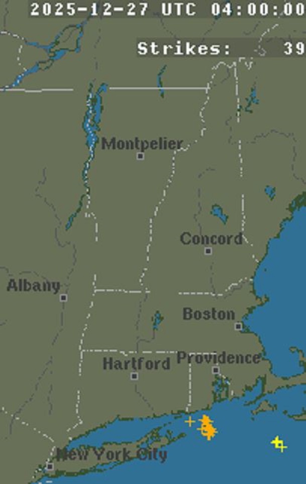
Wounded Duck Strikes Back: Dec 26 & 27th Winter Storm Obs
vortex95 replied to WxWatcher007's topic in New England
39 CGs between 00 and 04z. Not bad!
-
The 18z gfs wasn’t that bad. A “disaster” run would be a torch with 5 to 10 C 850s with a constant stream of western cutters. This one always had the boundary close or just south of us with some shots at us. A couple of those shots were a bit warm, but at that range, it wouldn’t take much at all. 500s look good.
-
Looks more like snow squalls coming from Great Lakes and up north. Not really a clipper system. Spotty precip at best, just dry and strung out
-
Go with JI on this one. Lol
.thumb.png.4ffab2bbe4868bded2fc37beab024f99.png)
-
Where did you get your 18z NAM numbers?
-

Boxing Night Snow/Sleet/Ice Dec 26-27 Storm Thread/Obs.
KamuSnow replied to Mikeymac5306's topic in Philadelphia Region
Good practice for driving in snow! One Saturday night we went bowling and when we came out the parking lot was a sheet of ice. Even better it was on a slight incline, so you could do a string of donuts moving downhill. Good stuff! A few years later they ruined it by putting planters etc. all over it. Lol. -

Winter 2025-26 Medium/Long Range Discussion
RogueWaves replied to michsnowfreak's topic in Lakes/Ohio Valley
Because you've already gotten a big storm. DTW/TOL haven't. -
18z (EURO AIFS, GFS, and AIGFS)...yuck. Ensembles appear steady, but that is a big time warming trend across deterministic modeling at 240. I wouldn't call if a flip, but welcome to wx model watching this winter. Yet again, we are likely dealing with feedback...this time w/ an Alaskan vortex which cuts off our cold air supply. That kind of makes sense, but the downstream effects are just model chaos. Do I think it spins up that strong? Nope. It probably is a legit player, but like so, so many other features this winter past d8...it is likely over amped to a point it just ruins the run from a rigor standpoint. Also, we are seeing a trend for the NAO to simply evaporate. That could happen. It is very difficult to model. The good trend is that there is a trend for a western ridge by Jan10. A reasonable model bias(and not feedback) is to break down the NAO too quickly. I am guessing that is in play. But the 18z deterministic suite is about as ugly as it gets, and a complete flip from 0z and 6z. Thankfully, most of that is in fantasy land.
-
.thumb.png.4150b06c63a21f61052e47a612bf1818.png)
December 2025 regional war/obs/disco thread
HIPPYVALLEY replied to Torch Tiger's topic in New England
Hoping Greenfield can at least lock in a decent glaze for Monday sunrise so I can get some good pictures. -
It’s only not relevant if you ignore the warming temperatures since then.
-

Central PA Winter 25/26 Discussion and Obs
Mount Joy Snowman replied to MAG5035's topic in Upstate New York/Pennsylvania
My daytime temp never got above 33 today. Now at 31. Been a fair amount of low busts in the temp department lately. Love it. -
Climate is dynamic and ever changing, 1840s is not relevant
-

Central PA Winter 25/26 Discussion and Obs
Jns2183 replied to MAG5035's topic in Upstate New York/Pennsylvania
What's nuts are there are people within 10-15 miles of me who are above 60", even close to 70" for the year. Convection seems to be all that matters any more. Sent from my SM-S731U using Tapatalk -
Mele Kalikimaka a warm Hawaiian Christmas!


.png.36e4f086b9854c0d072c3201a083e26b.png)


