All Activity
- Past hour
-
+4 at SLK is still a very cold winter for 90% of New England lol.
-
I have this feeling too, and if you think about it, the warmer December is the colder JFM can be and still the winter can average normal to slightly above overall. I am almost ready to root for this as it feels close to a lock anyway.
-

2026 Mid-Atlantic Severe Storm General Discussion
EastCoast NPZ replied to Kmlwx's topic in Mid Atlantic
And miss it will. -
(002).thumb.png.6e3d9d46bca5fe41aab7a74871dd8af8.png)
E PA/NJ/DE Summer 2026 Obs/Discussion
ChescoWx replied to PhiEaglesfan712's topic in Philadelphia Region
Me too! -

Augdewst 2026: Summer's Last Stand
powderfreak replied to Prismshine Productions's topic in New England
Bummer on the snow depth down to 0”. -
Long time, everyone. Looks like the names are mostly the same. I live in Stephens City. We’ll see how it goes I guess. .
-
We just got back from a trip to Portugal, Spain, and the UK. All I can say is they have had a very long, hot, and incredibly dry summer. The leaves in London are all falling from the lack of rain and the grass is all burnt out. When we were in London it was their first "cool" shot of the whole summer, but moisture starved front, so no rain. It felt like October the first night we were there, but looked like it even more with so many leaves on the ground. We did not see one cloud the whole time we were in Portugal and Spain though. Weather was hot hot hot, especially in Spain. Great trip overall though. Really incredible places. Now hopefully we can maybe dry out just a bit...
-

2026 Mid-Atlantic Severe Storm General Discussion
dailylurker replied to Kmlwx's topic in Mid Atlantic
A tornado through Stephen's City would be funny, but not funny at the same time. Hail core headed right for Stephen's City. I can't wait to see how it misses lol- 2,174 replies
-
- 1
-

-
- severe
- thunderstorms
- (and 7 more)
-
Torch!
-
This is actually a good series to go to since we are 5 games away from .500 (the problems don't start until we're 3 games away), and we have randomly owned the Rays for some strange reason this year, lol
-
Looks like its re-intensifying... hail core has reappeared
-
Mesoscale Discussion 2091 NWS Storm Prediction Center Norman OK 0502 PM CDT Sat Aug 22 2026 Areas affected...Portions of western/central Virginia and northern North Carolina Concerning...Severe potential...Watch possible Valid 222202Z - 230030Z Probability of Watch Issuance...40 percent SUMMARY...Storms are expected to increase in coverage while spreading eastward into this evening. The primary concern is locally damaging wind gusts. While a watch is not currently expected, trends are being monitored. DISCUSSION...Thunderstorms are increasing in coverage along the Blue Ridge in western VA, potentially aided by increasing midlevel height falls preceding a broad midlevel trough approaching the region from the west. Over the next few hours, these storms should continue spreading eastward across western/central VA and northern NC. A warm, moist, and uncapped air mass downstream should support a modest increase in thunderstorm coverage. While midlevel lapse rates are limiting overall buoyancy (around 1000-1500 J/kg MLCAPE), an elongated midlevel hodograph (40 kt of 0-6 km shear per FCX VWP) could promote a few loosely organized clusters capable of producing locally damaging wind gusts. While the overall risk may remain too localized/sparse for a watch, trends are being monitored. ..Weinman/Thompson.. 08/22/2026 ...Please see www.spc.noaa.gov for graphic product... ATTN...WFO...AKQ...LWX...RAH...RNK...GSP... LAT...LON 36568122 36908125 37628037 38057977 38737887 39377837 39447792 39237739 38807712 38207722 36967810 36137933 35987997 36008043 36298116 36568122 MOST PROBABLE PEAK WIND GUST...55-70 MPH MOST PROBABLE PEAK HAIL SIZE...UP TO 1.25 IN
-
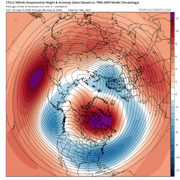
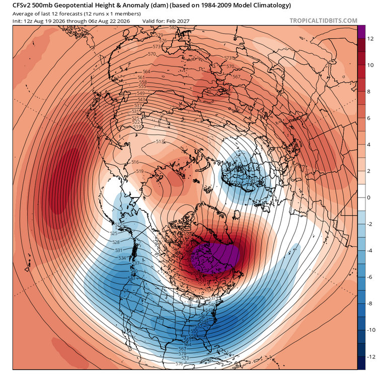
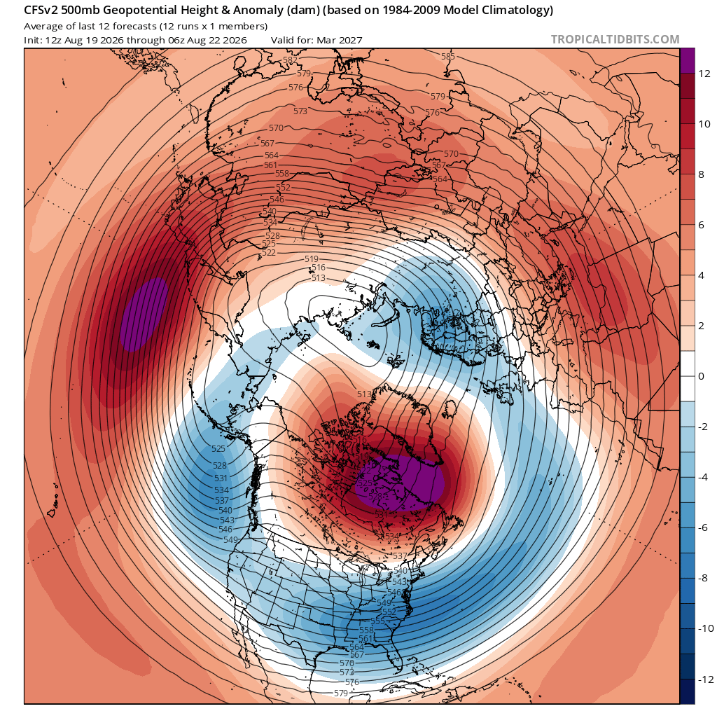
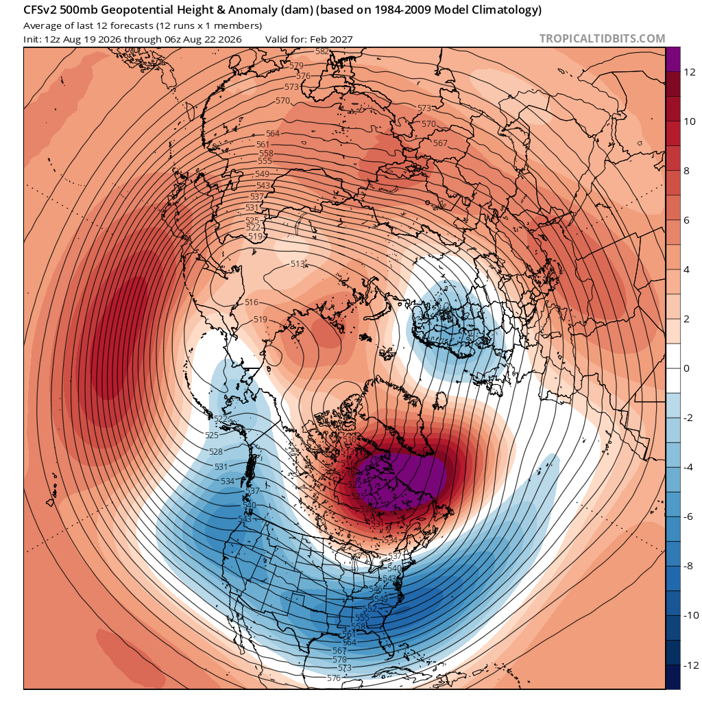
The CFS has been remarkably consistent in suggesting Feb and March will hold the best chance for cold and a big winter storm. Dec h5 pattern looks very mild with PAC puke look, and Jan might trend colder towards the end. Not surprising that the latter part of winter has the best potential to deliver when the Nino may relax a bit/ max SST anomalies shift more westward. All fwiw ofc. Pretty nice looks here. Should be just cold enough a time or two as the key features shift/ align in a favorable configuration.
-
Wouldnt trust them especially with timing Seemed to have struggled with this system ever since Thursday
-
What the... what is this Severe Weather Statement National Weather Service Baltimore MD/Washington DC 614 PM EDT Sat Aug 22 2026 WVC027-031-222245- /O.CON.KLWX.SV.W.0435.000000T0000Z-260822T2245Z/ Hardy WV-Hampshire WV- 614 PM EDT Sat Aug 22 2026 ...A SEVERE THUNDERSTORM WARNING REMAINS IN EFFECT UNTIL 645 PM EDT FOR NORTHEASTERN HARDY AND SOUTHEASTERN HAMPSHIRE COUNTIES... At 613 PM EDT, a severe thunderstorm was located near Wardensville, or 14 miles southeast of Romney, moving east at 10 mph. THIS IS A DESTRUCTIVE STORM FOR SOUTHERN HAMPSHIRE COUNTY. HAZARD...80 mph wind gusts and two inch hail. SOURCE...Radar indicated. IMPACT...Expect considerable damage to trees and power lines. Your life is at significant risk if outdoors. In addition to some trees falling into homes, wind damage is possible to roofs, sheds, open garages, and mobile homes. Locations impacted include... Rio, Yellow Spring, Delray, and Capon Springs. PRECAUTIONARY/PREPAREDNESS ACTIONS... This storm is producing destructive winds and large damaging hail. SEEK SHELTER NOW inside a sturdy structure and stay away from windows. Continuous cloud to ground lightning is occurring with this storm. Move indoors immediately. Lightning is one of nature`s leading killers. Remember, if you can hear thunder, you are close enough to be struck by lightning. Torrential rainfall is occurring with this storm, and may lead to flash flooding. Do not drive your vehicle through flooded roadways. && LAT...LON 3913 7869 3920 7867 3926 7846 3912 7845 3911 7848 3910 7850 TIME...MOT...LOC 2213Z 273DEG 8KT 3917 7861 TORNADO...POSSIBLE THUNDERSTORM DAMAGE THREAT...DESTRUCTIVE HAIL THREAT...RADAR INDICATED MAX HAIL SIZE...2.00 IN WIND THREAT...RADAR INDICATED MAX WIND GUST...80 MPH
-
Prettymuch solid cloud cover over southern half of New England, but the sinking air produced a ribbon of clearing north of the mountains: https://www.star.nesdis.noaa.gov/GOES/sector_band.php?sat=G19§or=ne&band=01&length=36&dim=1
-
That cell west of winchester means business
- Today
-
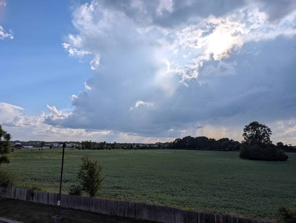
New apartment in mt. pleasant, 3rd floor balcony with a due west view is pretty nice, will try and share as many (compressed) flicks as I can on here this year
-
Sure is extremely workable for the interior of NE Siberia...
-
Yup, misery mist started around noon, lasted all afternoon until 5 when we had a steady light rain…So much for mowing the lawn this weekend
-
Parts of the region will see some showers or thundershowers tonight into the first half of tomorrow. Afterward, clouds will break and the mercury rise toward 80° tomorrow. Monday through Wednesday will be mostly sunny and pleasantly cool days. Highs will generally top out in the upper 70s. Showers and thundershowers could move through the region on Thursday. Temperatures will remain in the upper 70s and lower 80s into next weekend. No excessive heat appears likely through the remainder of August. The ENSO Region 1+2 anomaly was +4.0°C and the Region 3.4 anomaly was +2.7°C for the week centered around August 12. For the past six weeks, the ENSO Region 1+2 anomaly has averaged +3.80°C and the ENSO Region 3.4 anomaly has averaged +2.32°C. The ongoing strong El Niño, which has reached super El Niño threshold, will continue to strengthen through the summer. The SOI was -30.23 today. The preliminary Arctic Oscillation (AO) was +0.316 today. Based on sensitivity analysis applied to the latest guidance, there is an implied near 55% probability that New York City will have a cooler than normal August (1991-2020 normal). August will likely finish with a mean temperature near 75.9° (0.2° below normal). Supplemental Information: The projected mean would be 0.7° above the 1981-2010 normal monthly value.
-

Augdewst 2026: Summer's Last Stand
Damage In Tolland replied to Prismshine Productions's topic in New England
Picked up .07 of no rain today. Of course it stops after done moving in . After the disaster Needless to say , this was jacked and cranked up all the way home from Uconn . Like legit cranked .. -

Augdewst 2026: Summer's Last Stand
tamarack replied to Prismshine Productions's topic in New England
My 2011 Ranger's automatic transmission broke last summer. Then I learned that 2009-11 Rangers with 2.3 engine and auto tranny tended to break at about 150k. Mine broke at 163+, and all those broken transmissions made replacements rarer than hen's teeth, with a huge price attached. Sold it to someone who wanted the engine (which still ran just fine). Would love to find another, as I've driven the little trucks since 1994. 5-speed preferred. Forecast here has revised the 60-70% PoPs to 40%. Maybe we get the grass wet. -

Augdewst 2026: Summer's Last Stand
Chrisrotary12 replied to Prismshine Productions's topic in New England
Nice summer day we have. April misery mist. -

Augdewst 2026: Summer's Last Stand
CoastalWx replied to Prismshine Productions's topic in New England
Scooter knew.











.thumb.jpg.ad3a2e31d30aff035044689b311a0540.jpg)