All Activity
- Past hour
-
The way we have been overperforming rain events this year and have had two inch rain events this year, there's a chance we'll be above average by like Tuesday.
-
Some thinking winter is coming lol
-
Wanted to sit outside and watch the Bruins but got dinner going to late. Just went outside to get an Amazon delivery and wish I did. This is phenomenal. Who would ever want 30's and 40's or even 50's?
- Yesterday
-
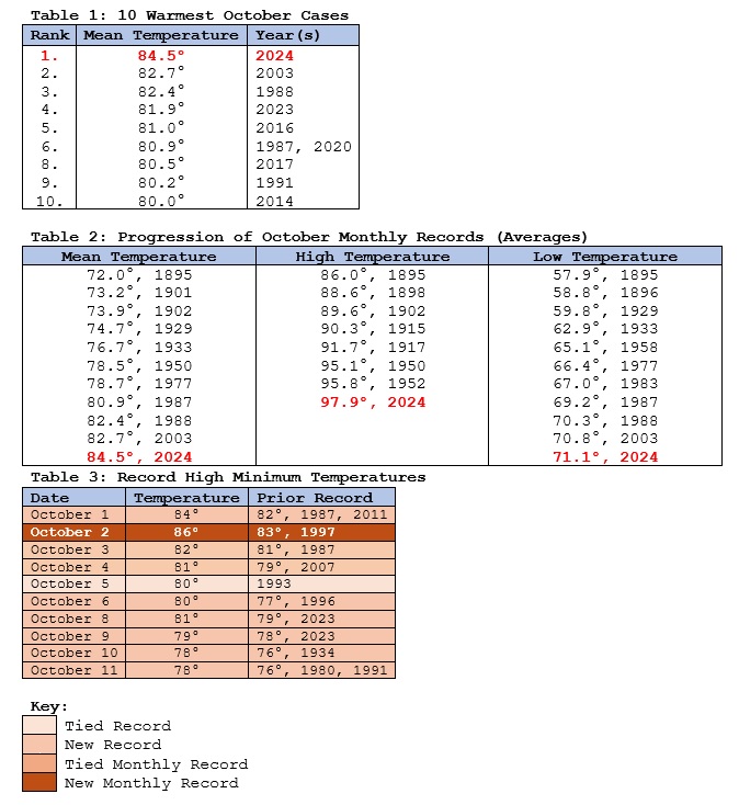
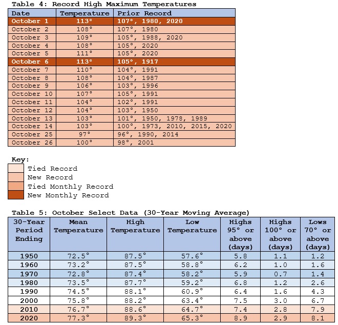
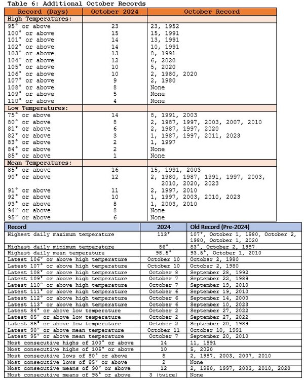
Powered by an unprecedented record-melting autumn heatwave that was unlike anything in the Southwest’s climate record, Phoenix experienced its warmest October on record. “Unprecedented” seems almost inadequate to describe the heatwave that stretched from the last week of September through the first week of October. During the first eight days of October, Phoenix eclipsed the previous monthly record high temperature on eight consecutive days. It also set a new monthly record high minimum temperature on two consecutive days. Climate change has played a large role. The 25th and 75th percentiles climate model projections (RCP 4.5) for fall were 72.9°-75.1° during 1961-1990 and 74.5°-76.7° for 1991-2020. The actual outcomes were 73.8° and 77.1°, respectively. The climate model projections for 2001-2030 are 75.1°-77.5°. The projections for 2011-2040 are 75.7°-78.2°.
-
I’m currently drinking a beer from heavy seas called winter storm. It’s gonna snow this winter and there’s nothing we can do about it.
-

Central PA Autumn 2024
canderson replied to Itstrainingtime's topic in Upstate New York/Pennsylvania
I see our chance of rain early tomorrow is basically dead. Cool, cool. -

Summer-Fall 2024 Weather Disco Med/Long Range
Matthew70 replied to John1122's topic in Tennessee Valley
Interesting snippet I found out today. For first time in over 130 years Mt. Fuji does not have any snow at the top at Halloween.- 567 replies
-
- heat
- thunderstorms
- (and 7 more)
-
Same. Summer is now 7 months long
-

Blowvember - and not named for wind potential
Damage In Tolland replied to Go Kart Mozart's topic in New England
How much rain have you had since Aug 20? -
Get used to it moving into winter
-
8PM TWO: Tropical Weather Outlook NWS National Hurricane Center Miami FL 800 PM EDT Thu Oct 31 2024 For the North Atlantic...Caribbean Sea and the Gulf of Mexico: 1. Southwestern Caribbean Sea: A broad area of low pressure is likely to develop over the southwestern Caribbean Sea during the next day or so. Gradual development is possible thereafter, and a tropical depression could form over the weekend or early next week while the system drifts generally northward or northwestward over the central or western Caribbean Sea. Regardless of development, locally heavy rains are possible over portions of the adjacent land areas of the western Caribbean. * Formation chance through 48 hours...low...10 percent. * Formation chance through 7 days...medium...60 percent. 2. Northeastern Caribbean Sea and Greater Antilles: A trough of low pressure near Puerto Rico is producing widespread cloudiness and showers over the Dominican Republic, Puerto Rico, the Virgin Islands, the northern Leeward Islands, and the adjacent waters of the Atlantic and the northeastern Caribbean. Slow development of this system is possible during the next 2-3 days as it moves west-northwestward near the Greater Antilles. After that time, this system is expected to be absorbed into the low pressure area over the Caribbean. Regardless of development, locally heavy rains are possible during the next several days from the northern Leeward Islands westward across Puerto Rico and Hispaniola to eastern Cuba and the southeastern Bahamas. * Formation chance through 48 hours...low...10 percent. * Formation chance through 7 days...low...10 percent. 3. North Atlantic: A storm-force non-tropical low pressure area located about 500 miles west of the western Azores is producing limited shower activity. Some subtropical development is possible while the low moves generally eastward during the next few days. Additional information on this system is available in High Seas Forecasts issued by the National Weather Service. * Formation chance through 48 hours...low...20 percent. * Formation chance through 7 days...low...20 percent.
-
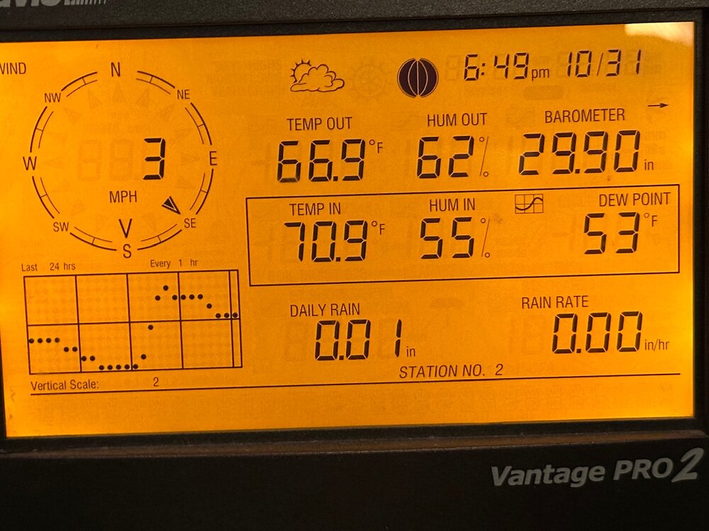
We Embrace and enjoy. 67 here…it’s beautiful.
-
There’s literally hundreds of crickets chirping out there . I noticed it on this mornings run too . You wonder if they’re chirping Xmas morning
-
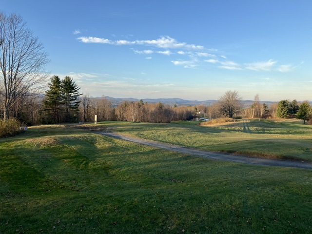
So I bought new irons earlier this year and I’ve done ok with them. Still need lots of work from the fairway. I seem to hit them better with a little grass underneath the ball and our fairways tend to give pretty tight lies. Late in the year I made what I consider my best golf purchase ever, a Ping G430 driver. I didn’t get a massive increase in distance but my consistency has greatly improved. It’s especially noticeable with my mishits. Don’t get me wrong, I’m still a 19-20 handicap but my driving is so much better. I sort of don’t want the season to be ending. At least it’s gone out on a beauty.
-
70 and mosquitoes on Halloween. lol.
-
Mostly warm and continued dry for the next 10 days at least as it looks now. Maybe a shot at some light rain around the 10th per some guidance. Way out there and no signs at all of a drought buster. If warmish and continued dry is your vibe, you love to see it. Enjoy. For those who want to see cool weather and maybe some actual rain, it's a continuation of shit the blinds. Reevaluate towards mid Nov.
-
There’s a good chance we’ll be above the full month average November precip a week from
-
T’was a beautiful night to get in what will likely be my last round of the year. Course closes Sunday.
-
Pittsburgh, PA Fall 2024 Thread
TheClimateChanger replied to TheClimateChanger's topic in Upstate New York/Pennsylvania
-
Some spots to our north approached +30 today. THE WATERTOWN NY CLIMATE SUMMARY FOR OCTOBER 31 2024... VALID TODAY AS OF 0400 PM LOCAL TIME. CLIMATE NORMAL PERIOD: 1991 TO 2020 CLIMATE RECORD PERIOD: 1949 TO 2024 WEATHER ITEM OBSERVED TIME RECORD YEAR NORMAL DEPARTURE LAST VALUE (LST) VALUE VALUE FROM YEAR NORMAL ................................................................... TEMPERATURE (F) TODAY MAXIMUM 78R 2:30 PM 72 1989 53 25 42 MINIMUM 63 6:25 AM 15 2002 35 28 26 AVERAGE 71 44 27 34
- 1,164 replies
-
Yep two in a row, last year was much snowier but this still counts. Western suburbs have snowcover, for the most part it was white rain here in the city. Warmest autumn so far on record and we still manage our first snowflakes in October.
-
Comfortable night handing out candy for sure.
-

Pittsburgh, PA Fall 2024 Thread
ChalkHillSnowNut replied to TheClimateChanger's topic in Upstate New York/Pennsylvania
We needed the front to move through one day earlier!

