All Activity
- Past hour
-

Augdewst 2026: Summer's Last Stand
Typhoon Tip replied to Prismshine Productions's topic in New England
I think I'd like to see that just because we don't seem to get coastal storms worth a shit nearly as often as yester-decades and the general dearth of ...anything really to substantiate and qualitatively argue for even having this hobby has become very challenging. Otherwise? have fun with 4 and half months in dark mud season stern. -
Picked up .49" rainfall last 24 hours. August up to 5.47" here. Everything green as could be. I honestly don't think I've watered anything but some flowers in pots that are in full sun since late May. Have not had to water the lawn at all since late May. If we can just have modest rains for the next 6 weeks or so to wrap up the growing season that would be great. Daylight getting noticeably shorter now both morning and evening. Will start to drop off quickly as we get into early September. While not over by any means Summer is on the run.
-

Augdewst 2026: Summer's Last Stand
tamarack replied to Prismshine Productions's topic in New England
That would be a real stretch here, as benchmark-track storms are usually whiffs or grazes. The big midwinter wind/rain events like Jan 10 & 13, 2024 come with lows a lot closer. The forecast 1/2-1" rain is a no show - now it's progged for >0.1". -

Augdewst 2026: Summer's Last Stand
TauntonBlizzard2013 replied to Prismshine Productions's topic in New England
Outside of a couple quick hitting rain events, this summer has completed lacked any appreciable storms or even showers. Bone dry around here overall. A pond people fish at locally now only has water around the middle. Pretty crazy, never seen that. Rocks and all kinds of stuff exposed -

super el nino banter thread
Brian5671 replied to forkyfork's topic in Weather Forecasting and Discussion
Not sure who is expecting a cold/snowy winter. I would think most know what's coming. -
40's n 50's around the area this morning. Low 40's for some inland n upper 50's near shore, so quite the spread. Low 80's in town yesterday. Was nice sitting outside with family for my granddaughters birthday. One thing I've noticed this year is no movement of geese yet. Not uncommon to have small flocks on the move about now. The last few years, I notice a flock or two about once a week. In a couple weeks they will be moving a bit more, for sure. Summer is rapidly coming to an end, and it already has hints of Fall with it.
-
Ended up with 0.09" in the rain gauge last night. And half of that was probably condensation from from how gross it is outside.
-

super el nino banter thread
forkyfork replied to forkyfork's topic in Weather Forecasting and Discussion
triggered
-
You were correct ! A Flash Flood Warning was issued here last night and early morning. Training cells for almost an hour. 1.42 of rain here. 3 inches for the month so far. Pattern looks active later in the week. WPC https://www.wpc.ncep.noaa.gov/discussions/hpcdiscussions.php?disc=pmdepd
-
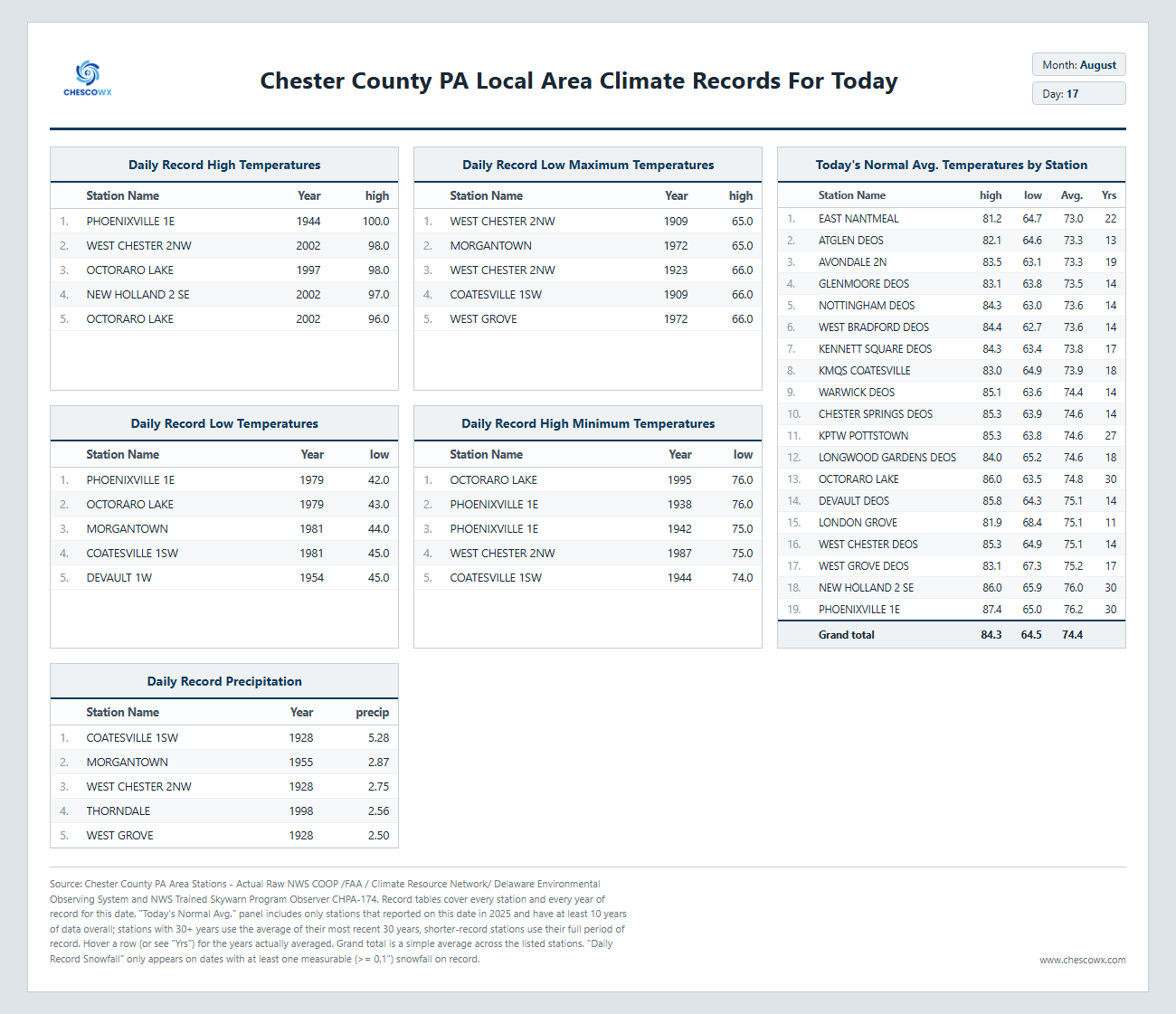
August 17 1946: A tornado kills 11 people in the Mankato area around 6:52PM. A 27-ton road grader is hurled about 100 feet. Another tornado an hour later destroys downtown Wells. For Monday, August 17, 2026 1915 - A hurricane hit Galveston, TX, with wind gusts to 120 mph and a twelve foot storm surge. The storm claimed 275 lives, including forty-two on Galveston Island, with most deaths due to drowning. Of 250 homes built outside the seawall (which was constructed after the catastrophic hurricane of 1900), just ten percent were left standing. (The Weather Channel) 1946 - An estimated F-4 tornado killed 11 people and injured 100 others in the Mankato, Minnesota area around 6:52 PM. The deaths and most of the injuries occurred in the complete destruction of the 26 cabins at the Green Gables tourist camp, 3 miles southwest of Mankato. A 27-ton road grader was reportedly hurled about 100 feet. Another tornado an hour later destroys downtown Wells, Minnesota. 1969 - Camille, the second worst hurricane in U.S. history, smashed into the Mississippi coast. Winds gusted to 172 mph at Main Pass Block LA, and to 190 mph near Bay Saint Louis MS. The hurricane claimed 256 lives, and caused 1.3 billion dollars damage. Several ocean going ships were carried over seven miles inland by the hurricane. The hurricane produced winds to 200 mph, and a storm surge of 24.6 feet. Complete destruction occurred in some coastal areas near the eye of the hurricane. (David Ludlum) (The Weather Channel) 1987 - Evening thunderstorms produced severe weather in the Northern and Central Plains Region. One thunderstorm spawned a tornado near Fairbury NE, along with baseball size hail and wind gusts to 100 mph, causing severe crop damage west of town. Ten cities in the eastern U.S. reported record high temperatures for the date. Syracuse NY hit 97 degrees for the first time in twenty-two years. (The National Weather Summary) (Storm Data) 1988 - Fifty-five cities, from the Middle Mississippi Valley to the Middle Atlantic Coast Region, reported record high temperatures for the date. Beckley WV reported an all-time record high of 96 degrees, and Baltimore MD hit 104 degrees, marking their thirteenth day of the year with 100 degree heat. Chicago IL equalled a record with 46 days of 90 degree weather for the year. Thunderstorms produced severe weather from Wisconsin to New Jersey. Thunderstorms in New Jersey produced high winds which gusted to 92 mph at Wrightstown, and blew down a circus tent at Lavallette injuring fourteen persons. (The National Weather Summary) (Storm Data) 1989 - Morning thunderstorms produced three to six inch rains in Oklahoma, and the Arkalatex area of Arkansas, Texas and Louisiana. Tom OK was soaked with 5.98 inches of rain, and Foreman AR received 5.55 inches. Evening thunderstorms produced high winds in the Wasatch Front of northern Utah. Thunderstorm winds gusted to 66 mph at Salt Lake City, and flash flooding caused up to two million dollars damage to a marina on Lake Powell. (Storm Data) (The National Weather Summary) Observances: 17 Mon National Thrift Shop Day 17 Mon National Nonprofit Day 17 Mon National Black Cat Appreciation Day 17 Mon Baby Boomers Recognition Day 17 Mon Black Cat Appreciation Day 17 Mon National I LOVE My feet Day 17 Mon National Massachusetts Day 17 Mon National Workers’ Comp Adjuster Day
-
super el nino banter thread
Brian5671 replied to forkyfork's topic in Weather Forecasting and Discussion
yet you are still here.... -
Upper 40's for the low here. Have only had .25" of rain this month but surprisingly not even AD on the drought monitor. Will probably change with the next update. Fairly seasonable this week w/ a couple cooler nights likely. Averages for this area are 73/53 and sliding quick. The dry weather may cause the leaves to give it up a bit early this year. Changes are already visible in the higher terrain areas.
-
2026-2027 Record-breaking El Nino
Typhoon Tip replied to Stormchaserchuck1's topic in Weather Forecasting and Discussion
On more of a personal note ... if this ensuing "winter" isn't going to deliver - which frankly, having a CC as a launch pad upon which a warm ENSO of this ilk is sky rocketing off of, heh ... ah - good luck. Sounds like a warm synergistic massacre.. Not helping that we've had this upstream active solar disk fire hosing the 150 thru 1 kPa depths over the Pole for the last year. Anyway, I just would rather not have any of it because 4 months on mud as a season, in the dark, is some kind of middle earth dystopian shit. I'm not saying I don't have appreciation ( and hope ) for fantastic winter patterns and consequence. But having a passion and fascination for winter weather events does not include the dreaded 42 F winter. The problem is, it takes a denier at this point to not sense the growing dearth of decent winters. Or at least it seems that way. A stab at an objective opinion here ..., let's see: CC + history-making warm ENSO --> plausible synergistic emergence between those not necessarily meaning cold (duh) + solar-cleansed stratosphere + this ... ...occurring under a lowering boreal heights? Explosive potential. Absolutely! That unfortunately does not include a cold or cryo-profile, necessarily. By and large, the last impressive winter, IMHO, goes all the way back to 2014-2015... and it wasn't actually the whole winter. And, it didn't really involve the larger community? Mainly a SNE/CNE affair. We just had 3 1/2 weeks of utter carnage in those sub-forum regions during February 2015; so overwhelming ... the constituency of these regions think that winter was phenomenal. I think that 3 1/2 weeks was a "planetary storm" - a concept pushed forth by a theoretical Met back in the last Century but damn! that was a great argument for his conjecture. Not sure that was a whole winter, though. I guess in fairness, getting 150 to 300% of normal whole season's snow, amid lung aching cold ... probably should qualify the whole winter? I don't need all that. Just give us a steady diet of nickle and dime storms that add appeal as an active winter pattern. There'll be potential to do more along the way. Maybe one will blockbuster. Otherwise, if I were god, I would make it 60 F with frequent runs at 70, in some sort of freak show scary warm time of it, so that I can continue with outdoor activities and just deal with 16 hours of darkness days. Also, I would look up all my enemies and afflict them with a kitchen renovation project - having been suffering this fuckin thing going on weeks now ... I've seriously gazed out at sunsets while deeply reconsidering life choices.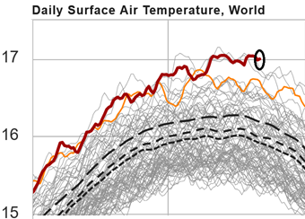
-
(002).thumb.png.6e3d9d46bca5fe41aab7a74871dd8af8.png)
Central PA Summer 2026 Discussion/Obs Thread
ChescoWx replied to Voyager's topic in Upstate New York/Pennsylvania
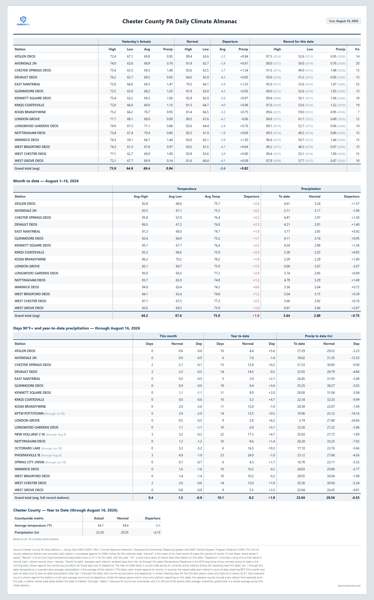
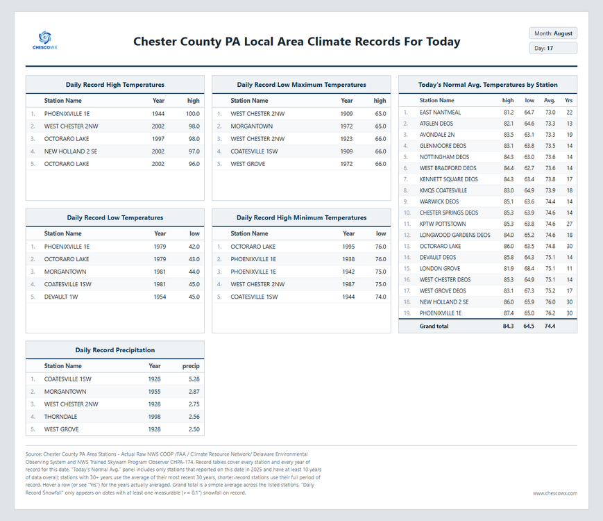
A general 1" to 3" of rain fell across the area yesterday and overnight with 3.18" recorded at the Warwick DEOS. We could see some sun retrun this afternoon with a slight chance of a shower toward evening before we clear out and see a couple great weather days both tomorrow and Wednesday. Humidity should also be less through mid-week. Shower chances return later Thursday afternoon and through the start of the weekend.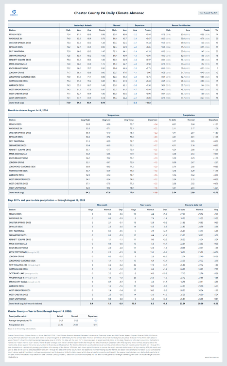
-
As you mentioned in your Chicago records thread, trending would suggest a clunker year. And that seems likely with what I'm seeing down the road.
-
E PA/NJ/DE Summer 2026 Obs/Discussion
ChescoWx replied to PhiEaglesfan712's topic in Philadelphia Region
A general 1" to 3" of rain fell across the area yesterday and overnight with 3.18" recorded at the Warwick DEOS. We could see some sun retrun this afternoon with a slight chance of a shower toward evening before we clear out and see a couple great weather days both tomorrow and Wednesday. Humidity should also be less through mid-week. Shower chances return later Thursday afternoon and through the start of the weekend.
-
All the events last week it was high by about .05". But last night it was low by .15" for mby.
-
1.24” yesterday
-

Spring/Summer 2026 Pattern Discussion Thread
dwagner88 replied to Carvers Gap's topic in Tennessee Valley
What's the criteria for an extreme heat warning? Seems like 112 should qualify, but we aren't under one: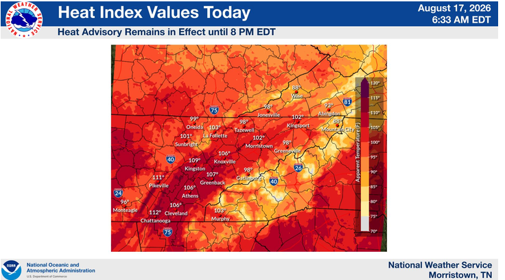
-
Happy to see we busted low on the rains last night
-

Augdewst 2026: Summer's Last Stand
HoarfrostHubb replied to Prismshine Productions's topic in New England
0.25” since midnight. Heavy mist? Light rain persisting. -
Yeah the only other time ive ever gotten poured on here was a few years ago. Was walking on the beach after midnight from a casino back to my hotel and got caught in a wicket thunderstorm. Was not a fun walk lol. For the most part the weather has been perfect here as usual.
- Today
-
I can't remember a stretch when we've had so many days of marginal/slight risk with only 20-30% chance of storms.
-

super el nino banter thread
A-L-E-K replied to forkyfork's topic in Weather Forecasting and Discussion
Mass holler extinction incoming -
I had a hot hand last summer. Mby was green and lush while 10 miles away looked like Stephens City. This summer is still pretty green but I've missed the good stuff. Glen Burnie and Pasadena to my north have had flooding, severe storms, and tornadoes. No fair!